Loading...
Committee of the Whole - Council Redistricting Discussion
Unknown Speaker
Are us
President Sheffield
be virtual All right, good afternoon, everyone. We will now call to order our committee of the whole if the clerk will please call the roll. Councilmember
Unknown Speaker
Benson? Council Councilmember Joe Hall, the third resident council member Johnson. Councilmember Santiago Romero present. Councilmember waters councilmember Whitfield Callaway present. Councilmember Yang, the seconds. Council President Pro Tem take your council President Mary Sheffield present. Madam President, you have a quorum.
President Sheffield
All right. Thank you so much. We have a quorum and we are now in session before we start our presentation, we're gonna go directly to public comment. We have individuals that are here and also who have joined us online. How many callers that we have online?
Speaker 1
Oh, good afternoon, Madam President. You have eight callers who raise their hand.
Unknown Speaker
Okay,
President Sheffield
and we have about 60 in person. So we're going to cut off our public comment and start with those who have joined us here in person or Shureido. peers will be first. Everyone will have a minute and a half for public comment. That afternoon. Just make sure your microphone is on press the bottom of the microphone and should turn green.
Speaker 2
Good afternoon. Thank you. So my name is Sarita Pierce, and I'm actually a president of a new neighborhood association by the name of strength in unity and our boundaries are from Gratiot Seven Mile care Kelly to Houston Whittier. And we realized that that is part of the boundaries that is looking to be switched to district three. So our concerns are we have stakeholders that invest in our community. And our master plan within our 5013 C is to go towards Harper. We have properties down here as well. All the way up to seven out and I'm sorry I might be nervous. That's probably why I sound like this but okay. So basically, in a nutshell, we do not want to be redistrict. We want to continue to build our neighborhood association heading south towards Harper. So that's pretty much it.
Unknown Speaker
Thank you.
President Sheffield
Thank you. Thank you for coming down. We appreciate it. Michelle George, followed by Ronald Foster.
Speaker 3
Good he needs to have good afternoon to this honorable board. I've just downloaded just to make a public comment and that to tear our district apart. We know you're not going to vote today but it's just something we stand strong with that especially as we deal with gerrymandering and what's going on just acclimate to what's happening with democracy across the country. So that's why I'm here. Thank you.
President Sheffield
Thank you. Thank you, Miss George.
Speaker 4
Afternoon, I just want to say that change is important. I look forward to change the value change. This particular change only happens once every 10 years. You guys are in a unique position to be involved in it. Just encourage you all to do your best to get it right. I appreciate it.
President Sheffield
Thank you so much. Mr. Foster, Sean long, alibi Sherry burden.
Speaker 5
Hello, counsel. Just want to make a statement that you know you see us here often. We have worked extremely hard in the last 10 years to get our community up and running. We have made a lot of progress. We currently have been involved in two framework studies that cost lots of dollars and before you make a decision to split us up, think about those things that we have invested in. And I know we don't have an opportunity at all to talk to each one of you separately. And I know you have a job to do, but please engage with us, not just our council person, but at large and those that may be affected by this change. We look forward to coming back down here and speak with you on several occasions before the January cut off. Thank you.
President Sheffield
Thank you so much.
Speaker 6
Good afternoon. Thank you for allowing me to speak. I'm also familiar with neighborhood that Shannon was just speaking on and you all have seen us often as she said because we advocate heart we respect our neighborhood. It's a legacy neighborhood. We live in homes that were purchased by our grandparents. Parents or some other close relatives. So we go hard for that area because we have respect for what our parents our legacy yielded us and we want to hold on to it and want it to have a quality of life. So this is not the first time we will speak but here's the fat keep Midwest neighborhood intact. Thank you.
President Sheffield
Thank you, Amanda Matthews. Everyone and Carol.
Speaker 7
Good afternoon. I'm Elle Matthews, Executive Director of Greenway heritage Conservancy. Today I speak with a deep sense of concern and commitment regarding the Midwest neighborhood. Our community faces a pivotal moment grappling with proposed redistricting that could fundamentally alter the fabric of our neighborhood. Considering changes to this community feels like disrupting a family bond, jeopardizing the very essence that has propelled our progress. It's disheartening that our District Six city council representative did not find it necessary to engage in a dialogue about this matter with us. The very residents deeply invested in the prosperity of the Midwest neighborhood. We believe our community's voice deserves to be a part of decisions that shape its future, regardless of whether she agrees with that or not. We earnestly request that this council proposed the vote. Well, we know that you're going to go into that vote today and we thank you all for that grant the residents of Midwest the opportunity to actively participate in this dialogue ensuring that the decisions made aligned with the best interest of our community. Please ponder the lasting impact of this decision on our community and to keep us together. This is not merely a decision for today. It's a legacy we are collectively shaping for the future. We trust our voices will not only be heard, but considered with the gravity they deserve. Thank you for your time.
President Sheffield
Right. Thank you,
Unknown Speaker
Madam President.
President Sheffield
Yes, Member Santiago Romero.
Speaker 8
Thank you, Madam President. I'm very happy to see so many folks here from District Six and Midwest higher my neighborhood. Just a note. This is the first time City Council was discussing the redistricting. My office is planning on having conversations about this in the district and we did let folks know that emailed us concerned about a vote today, which we're not going to have that we're not having a vote and we are going to have meetings about this in the districts. Thank you, Madam President. Thank you, Council Member
Speaker 9
Good afternoon as someone Carol, president united block club Council representing large Mapbox clubs, class at my community, three Pacific Oregon, Cardinal Foundation and others in the Midwest time and area. We understand you're not doing voting or anything today. But we want to be gauged before these maps and options and draw our neighbors. Our neighborhood has worked so hard with our framework from the planning department to elevate our neighborhood and if you decided to split Midwest timing up, we voted for our representative but if you push us into another other districts, we're going to be represented by people that we did not vote for. So that just negates our voting rights. So in conclusion, just it was together, recognized that our neighborhood wants to be together. And we've just worked so very hard to elevate and communicate to all of our neighbors and our three neighborhoods. What's going on a city council. Thank you.
President Sheffield
Thank you.
Unknown Speaker
Miss lindo.
President Sheffield
Hello, by Patricia beer.
Unknown Speaker
My name Hello.
Speaker 10
We are part of district two. I am the Vice President is that I am the Vice President of the Woodward West wouldwould Parker's West black club. This is the president of that. We strongly propose that we stay in part of district two. We want to continue the work that has been started in district two. By move enough this negates our vote for the council person that we voted in. And it it appears that our vote does not matter. It also is in district two we feel those that are being moved. That it is all about the numbers. It is not about representation, nor accountability. As a the vice president of the Black club. It is our sentiment sentiment. That we stay in district two. Thank you.
President Sheffield
Oops, I don't know what that was. What's your name? Okay.
Speaker 11
I just wanted to say that in 2009 The citizens of Detroit voted for districts. And there was a reason for that. We wanted to know that we were represented that our concerns would be addressed and we thought it would be done in a more effective way if we had districts but those were all people who voted people, not numbers. And these redistricting options are all about numbers. But you have people behind these numbers. And we have had a council person that has worked with us. She has done some wonderful work to get us started. And we want to see it continued. So whether it's district or whether it's option two or any other option that keeps us in district two is the one that we would like for you to support. Thank you. Thank you
President Sheffield
Suzanne Quinn. alibi Timothy Quinn.
Speaker 12
Hi. I would just like to express that we're in district two we're residents of grix Dale farms and we have been for six years now. We are along the river before that. And we very much enjoy the amenities at Palmer. Park and the things that are nearby us. I think that by redistricting our grid stale farms area into district three, we would not be part as much of those amenities. And I think if our neighborhood would have purpose and goals that would be to participate more so with the liver neu business district and with Palmer park, so I think that the natural break might be I 75 rather than moving it all the way over to Woodward as we develop our block club as we've been encouraged to do so by our council representative. I think we're finding that our personality as a group is more so in line with with district two so thank you very much.
Unknown Speaker
Thank you
President Sheffield
Timothy Quinn.
Speaker 13
Good afternoon Council, President Sheffield and my council person Callaway, Timothy Quinn in district two that was my wife Suzanne spoke just before me. We've specifically made decisions to live in the city of Detroit. I was born here I was out for a while came back many years ago and it was six years ago that we made a conscious decision to move specifically into district two. We wanted to be in the association that also included Palmer park there. And with this redistricting, redistricting, there is an opportunity that we could be moved out of that and I have some concern about that. We've been working on a community association in fact we have another meeting this evening at six o'clock based on where we are now and that could change some of the parameters of that block Association. We've put a lot of effort into it at this point. I understand the changes that are necessary for equity. But I'd like you to consider the fact that there is a community there that has worked very hard to support and create a future for that area. Thank you.
President Sheffield
Thank you. Jennifer Williams.
Speaker 14
Yeah, counsel, how are you? I am Jennifer Williams. God bless you all. First of all, I would like to say I am here on behalf of my group. And as you see those lovely people up there that we belong to they're my family. And this redistricting and the red lining to me is what it's called as a kid. That is what I knew when I grew up, and they continue to split us up. I'm asking you to think about what you're doing. When you boundary like they say with numbers. I'm still fortunately to be alive and to live a lifelong resident in Detroit. I'm very active in my community, and we have some great things going on. Please don't break up this family. Please think about it when you're doing these red lines in these districts and this was 10 years ago. How many of us have lost our families because of that? I have adopted two people from my family, to represent me to love me and to stay with me. So I'm asking you when you do vote for this, please think about what you're breaking up. Please think about how you divide us. And we've been boots on the ground. I've spent 66 years began at Detroit. Okay, and I stay because I love this place. And I want to see us stay together. Please don't break us out. Thank you
President Sheffield
Thank you. We appreciate you. Thank you should not follow by Chris Gilmer Hill.
Speaker 15
Morning, morning. I'm here representing Midwest. Detroit neighborhood. I'm also president of neighbors from lenders do block club. I'm a bit upset at the rezoning proposals and just don't want Midwest neighborhood to get broken up. We have worked very hard, especially the past 10 years and I've been a part of this organization. I deal with a bunch of ladies who have lived in the neighborhood for a long time and know exactly what they're talking about and know what they're doing. We've been working hard waiting patiently for a lot of changes to come to our neighborhood and they're finally starting to come to our neighborhood and breaking us up at this point. It will be very, very detrimental. It's like piercing the core of our neighborhood. Other districts as well are suffering. I've visited other districts and they're they're feeling the same pain. It's sad that they're not here today, but hopefully we can see them in the future at a future meeting. Once more information is provided. Again, I'm just here to ask that. Like everyone else, just please be considered with the with the voting population with the residents, not just the numbers when you're dividing up these neighborhoods, not just the districts please. Thank you. Have a great day. Thank
President Sheffield
you, you as well. Thank you.
Speaker 16
Good afternoon. My name is Chris Gulnar. Hill. I'm a resident of district two. And the big picture I recognize that as a group you have a legal obligation to take the numbers very serious here. This we do have to get even apportionment etcetera. We know that. I also know that we're very early in the process and there will be a lot more input from communities and I do trust you all to go out into the community and hear from the people about what communities need to be kept together. I am a bit concerned based on some comments that have come out previously. In particular, I know that Councilmember Benson has previously said he doesn't want to see two members run into the same district. And I would respectfully urge that that should not be one of your concerns here. Your job here is to make the numbers fit what's legally required and to protect communities of people in Detroit. Those would both come before any concerns about which incumbents may or may not be favored by these changes. Now a bit more in detail as a resident of district two I would also agree with some previous comments that I would really like to see our district remain in its current configuration of crossing Woodward. A bit. I think that it's very beneficial to have the communities just on the other side of Woodward, still included in our district. I think although big streets like Woodward can be a very easy dividing line when Brian these districts, it can be easy to sort of fall into following the same boundaries that have kind of segregated our communities in the past. So it will be possible to keep these groups together and to focus more on communities than on just easy boundaries. I think that'd be net better. There's also some other fixes. I'd like to see it in Midwest downtown but I'm struggling to get present.
Unknown Speaker
Thank you Thank you.
President Sheffield
Doug Marinda alibi Pam Becker rady.
Speaker 17
Hello, I'm Doug Miranda, president of Greek steel farms, district two and just as Linda and just as the Quinn said, I feel that District Two is we're very involved. We're at the eastern edge of district two. And it looks like from the three maps that were listed online and I understand there's two more maps that with redistricting. Other than option two, we will be placed in District Three. And we've enjoyed the benefits of District Two and having councilmember Callaway has been very active in keeping up Palmer Park and with keeping grip steel firms area very, very well keeping everything up. And I think that option two, which prioritizes the equal population is most in line with the law and that we should go with option two and therefore also, we would not be redistributed to district three, those of us living in Grisedale firms such as Linda, the Quinn's Pam, who's going to speak next. So I urge the council to vote for option two.
President Sheffield
Thank you
Speaker 18
Good afternoon. My name is Pam Becker Grady. I am part of District Two group still farms and I don't want to No offense to district three. But we'd like district to have been here for four years, 50 years, something like that. And if you do do a dividing line I think it would be more I agree with my cohorts here. I 75 makes better sense. We used to be on the other side. We're just this side of Woodward. Palmer Park is our home you know 12 precinct. They have helped us when we had no offense to the 11th precinct, but they're so far away and our crime was up at that point when we got back into where we're now Palma Park Police and everybody worked with us and we've been able to get our neighborhood looking good. Feeling good people are walking at all hours of the evening. In such a we don't want to broke up. We have a lot of seniors. Thank you.
President Sheffield
Thank you. Thank you. All right, that was our last in person and we will now turn it over to virtual public comment.
Speaker 1
Good afternoon, Madam President. The first caller with their hands raised is Mimi. Midwest. tyerman.
Unknown Speaker
Good to know can you all hear me?
President Sheffield
Yes we can. Okay,
Speaker 3
good afternoon. Council members and residents of the Midwest tyerman community. Thank you. With this up giving me this opportunity to speak. I am a resident of this area of District Six. And I request that the city council postpone this discussion and plans regarding the redistricting of the Midwest tyerman neighborhood we as the community do not want our area forcibly torn apart and assimilated into other districts. The community leaders and residents have fought too long and hard to restore and transform some of the Blight spaces to sustainable community spaces. Also, this has brought an era of unification and opportunity to create coalitions within the Midwest tyerman area due to the neglect of subsidy officials and our area being overlooked. Secondly, this information is not brought to the community in the Midwest tyerman area in a timely manner in order for us to discuss the ramifications of this move. We know that other districts such as one, two and four had a chance to come together to discuss this topic. Lastly, did the city or council members take into consideration the two framework studies that's being conducted in the Midwest tyerman area. Again, we request to postpone and we like we want to keep the Midwest tyerman area together. Thank you.
President Sheffield
Thank you. And just want to make sure it's clear for those who are calling in online as well that we are not taking up a vote at all today today is just the initial start of public engagement around the proposed maps that had been submitted. There will be no vote. In fact Council probably will not take this up until well, we won't take it up until after our recess which will be in January. So just wanted to make sure people were clear that there will not be a vote today. All right. next caller.
Unknown Speaker
next caller is Carol Hughes.
President Sheffield
Right Miss Hewes. Good morning.
Speaker 19
Good. Good afternoon. To the chair. May I be heard?
President Sheffield
Yes, ma'am.
Speaker 19
I think I think this is one of the things that happened to the city of Detroit when we went to districts. I think that the one thing we should do is get rid of districts. First of all, when we when we were when we were approached with districts, we were supposed to only have seven members. And that's how the proposal was written. And now I'm looking at nine so so all of it is is out the window. And to the poor people who think that they can't go to Chandler park because they live in another district, please the city belongs to all of us. They only chopped you up for you to have this kind of reaction. I have no vote of confidence in this particular body to do anything fair or equitable for the people in the city. I've watched you all year and all last year, so I know you're not capable of handling this type of situation. We need to get rid of districts go back to Detroit city as a whole and stop dividing the city up in pieces Thank you.
President Sheffield
Right, thank you.
Speaker 1
The next caller is William and Davis.
Unknown Speaker
Good afternoon. Can I be heard?
President Sheffield
Yes, you can.
Speaker 20
Okay, I'd like to start out by saying I do not like none of the options I have posted. I'm the Vice President of Barton McFarland Neighborhood Association. We one of the largest oldest neighborhood associations in the city of Detroit. You know, if it was up to me, if I had a vote, I would say that you should reach we calculate how you're doing this and have a maximum number of people in each district. 93 and the lowest number at 1350. That's within 5% of the maximum and I would try to keep the boundaries as close as possible as the current boundaries are. And I would say that districts so one to six and seven should have the 93,000 people and other districts would last the most people should have other numbers that reflect possibly their number as as the current balance. Also I agree with the fact that if you make dramatic changes to our districts, that there's no reason for us to go ahead and maintain these districts. You know, we might do better by just going to at large you know, like say vote but nine or just vote for seven people at large. You know, we are very disappointed with these numbers and these boundaries. So I bet you I could do about to do better. And I think that you should watch out three and have better boundaries. Thank you.
President Sheffield
Thank you so much.
Unknown Speaker
next caller is black bag. Ru.
President Sheffield
Good afternoon.
Unknown Speaker
Good afternoon. Can I be heard?
President Sheffield
Yes, you can.
Speaker 21
Well, it seems that like this retardedness is gonna go to the next level here in the city of Detroit. You know, at the age of 15. I was given the keys to apartment over there at 1905. Buy more drive for a 203 as a district two in the city of Detroit. I now reside at 13 Five, six for New Bern for a 212. That's district three in the city of Detroit. Coincidentally, the two districts were confirmed cases of absentee ballot fraud have been committed here in the city of Detroit in 2020 election. Very feel very propaganda propaganda Sheffield, you want to Detroit Election Commission. I've been trying to get the information you and Janice went free. And y'all keep referring me to crafty Conrad over the General Counsel at the Detroit law department. Now I don't know what he would have to do with absentee ballot fraud being committed. But this is a retarded. Now the most idiotic thing in a whole city of Detroit is that word where John R is the dividing line between the east side and the west side of the city.
President Sheffield
Mr. Crowley,
Unknown Speaker
would you want to excuse me?
Speaker 22
I was just gonna say we were going to refrain from using that word. There's a lot of words that we always have to make sure that we be careful about using because they are very offensive and sometimes you don't know and I'll give it to you. Maybe you didn't know that the R word was one that's offensive to a number of individuals. But I know that based upon the connection that I've had with individuals of my family and others so I would ask madam president if if anyone chooses to use that word again that we removed them from public comment. Thank
President Sheffield
you, thank you pro tem Are you can continue the time where it is and again if that word is used, we will end the public comment.
Speaker 21
You talk about the R word. Well, what if I decided to use the N word? I mean these words with these letters in front of them the C word the B word. The F word here regardless, or regardless to be correctly stated. It is what it is.
President Sheffield
Our next caller please.
Speaker 1
The next caller is Nancy Varner.
President Sheffield
Good afternoon Miss Varner.
President Sheffield
Good afternoon Miss Varner.
President Sheffield
All right. If we can come back to miss Varner, please.
Unknown Speaker
Next, next caller is Christopher Carter.
Speaker 23
Hello, from District Two and District Six. I am opposed to the redistricting. And I just hope that the city council will basically throw out the redistricting all together. I believe that we could deal with not changing the political landscape and the economic landscape of our districts. I love being in the Griggs Dale community that is, you know, basically a part of Palmer Park. At the end of my street is a piece of Palmer park so I would like to keep it that way. Thank you, and have a nice evening.
President Sheffield
All right, thank you.
Speaker 1
The next caller is phone number ending in 500.
President Sheffield
Or 500. afternoon
President Sheffield
father 500 Good afternoon.
Unknown Speaker
Hi, can you hear me now?
President Sheffield
Yes. Okay.
Speaker 24
Thank you. Good afternoon. This is Diane Patterson from the grandma's neighborhood in northwest Detroit. in district one. I am a current board member and a a resident of the grandma Rosedale communities. I'm asking that you keep the grandmas community which is comprised of eight streets, south of Southfield service drive. I'm sorry east the Southfield service drive to Asbury Park, between Grand River and Schoolcraft. together since we work together as a grandma Rosedale Development Corporation. Listening to all of the comments, everyone is passionate about their communities. And this is just it's really a sad situation that I think should not be used just with the census figures. There are disputes about those numbers in general, but communities need to be kept together. We've built relationships and we have foundations working forward within our districts. So thank you. I'm just hoping that you will keep grandma's community in district one with the other five neighborhoods that make up the four neighborhoods that make up grandma Rosedale. Thank you.
President Sheffield
All right. Thank you.
Unknown Speaker
The next caller is Karen Winston.
President Sheffield
Hello, yes.
Speaker 25
Good afternoon. Um, you know, actually, we're late doing this redistricting if we had done it. When we were when we were supposed to, you know, we wouldn't have all these issues with people feeling like they're being yanked away from their best buds. And stuff like that. But, you know, voting has consequences. Now, when the voters did when supposedly we decided we wanted districts, you know, we should have understood we have to understand the entire situation that we're jumping into, we just can't jump in and something and then, you know, now this legislature now, there's still this rule now. But one thing that's going in your favor is on the state level, they have decided that it's that the districting was done illegal, anyway, so you may get a reprieve yet, but yeah, I think that yeah, get rid of districts. Because look at how people are being so grab it, you know, this is mine. It's no, these are my people. You know, so no, I mean, this is one Detroit, you know, so it has the things that Eastside gets the west side should get, you know, no one should shouldn't be thinking that you know, no comp no individual console person should be thinking I'm doing this for my district know, that entire city. taxes, pay everyone's pay, you know, payroll, not just their console district. Person. Thanks.
President Sheffield
Thank you, Miss Winston.
Unknown Speaker
next caller is Renard Minh Shumsky.
Unknown Speaker
Hi, good afternoon. Can I be heard?
President Sheffield
Yes, you can. Okay,
Speaker 26
I'm speaking clearly as a resident of the city of Detroit District Six, and that was a long term resident 10 years ago when we did vote on the districts. This was probably one of the unintended consequences is that neighborhoods and communities were filled split apart or not adequately represented an issue is that some districts get more money and resources and some getting nothing. And I see that more of an issue than, you know, certain neighborhood organizations. We need to be clear with the residents that the city council boundaries are changing and not neighborhood boundaries as well. And the fact that you failed to provide maps to the public so we can properly deliberate about this. And I do agree with the previous caller, that the city is late on this process. However, I also do agree that the maps at the state of Michigan level are racist and they've sacrificed to black representation for partisan advantage. And other than that, we need to make sure that this process here is in touch with the residents as much as possible. And not just residents that are part of neighborhood groups, but all residents that are potentially able to vote and fairly count everyone based on population numbers, as well, too. So maybe this conversation about which district gets more resources and genders, whether we're actually fairly treating each district correctly. That's the rest of you. Thank you.
Unknown Speaker
Next caller is LaTonya Garrett.
President Sheffield
All right. Good afternoon.
President Sheffield
Good afternoon.
Unknown Speaker
Is Garrett.
Unknown Speaker
I do apologize. Can I be hurt?
President Sheffield
Yes, ma'am.
Speaker 27
Okay, good afternoon. So the calm so this is LaTonya Garrett. I just wanted to make sure that I'm getting the information that is needed to take back to my residence and the community in which I live in which is District Two, to make sure that we're participating to our fullest and hoping that you keep us whole. Thank you, counsel.
President Sheffield
All right. Thank you.
Speaker 1
And the last caller with their hand raised is Nancy Varner.
President Sheffield
Right Miss Varner Good afternoon
President Sheffield
All right, Miss Varner Going once. Going twice in Ms. Barn if you would like to submit your comment to the clerk's office, we will make sure that it is a part of the public record. And that will conclude our public comment for this afternoon. And we have joining us virtually Director Todd who will kick off the conversation with an overview of the process. So good afternoon, Director Todd.
Speaker 28
Good afternoon, Madam President, members of this honorable body. May I be clearly heard? Yes, we can hear you. Thank you very much. I do apologize for not being in person today but I am under the weather and will be assisted by Miss Jamie Murphy particularly if I do lose more of my voice than I already am struggling with. But do hope to get through this rather complicated issue in an expedited fashion. That being said there is much to present and obviously much to discuss, as has already been alluded to from the public comments that have been made. I will also be joined today by Adam Saxby from the law department who will provide the legal underpinnings underpinnings that we are governed by in this process. And certainly both Mr. Whittaker and Miss bar Cliff are vailable in person to assist as well. were owned by representatives from the election commission or elections department as there may well be questions for them as well. I believe. Mr. Daniel Baxter, certainly the director, Gina Avery Walker and others may be available there. Madam President, Do I have permission to share my screen thank you
Unknown Speaker
are you able to see the presentation?
Unknown Speaker
Yes, we are.
Speaker 28
Thank you. Let me quickly address a couple of the concerns that did come from the commentary from public comment with regard to the redistricting process itself. The proposed districts that are before you, once adopted would only initially be effective for the purposes of facilitating the 2025 election. So those comments that were made with regard to people losing their representation in terms of those individuals that they voted for, this would not be the case as the districts would not take full effect until after the election, and those individuals would be elected based upon the newly formed districts. Again, the concern of misrepresentation or unknown or not being represented by the individuals that someone voted for would not be the case because these districts would be the basis upon which the 2025 election is held. With respect to what we are here to address today, again, is what I think, as has also been stated is the result of the election by the citizens of the city of Detroit to enter into city council by districts. It is by necessity, and yes, it is very much above the numbers as you will hear later that we every 10 years following the census will address the voting districts whether they are local, state or federal, in accordance with the applicable laws, which again, Adam Saxby attorney from the law department will address shortly. So again, this is an unavoidable issue. It is also despite the expressed concerns with the census numbers and the challenges that the city put forward. It is also an undeniable that the city has lost population with a significant change in population loss or increase. Redistricting will be necessary in order to ensure that there is fair proper representation across those districts. Again, Mr. Saxby will address that. So what we would like to do as expeditiously as possible for this honorable body and the citizens is to walk you through the process to walk you through what we have done thus far. And again, what we have done consistent with what was done when the initial districts were adopted, is that the staff of the legislative policy division was asked to prepare this work. As indicated before your honorable body has not been a participant. In this. We have been working with the law department in order to draft options for your consideration. These these options could be further tweaked as is warranted again within the boundaries of the applicable law. And or additional options can be provided, as you requested of us two weeks ago today. So again, our initial report from the legislative policy division provided you with three options and 202 weeks ago today you asked that we provide you with an additional set of two options, as well as some guidance. And you have that under the cover of our report, which was circulated yesterday. Again, dated November 13. In short, we do provide those two additional options which we will walk through along with the other options. We will provide you with a very brief overview and then we will use option four to provide a more detailed overview so that individuals when they see the work that we have done via posting of the information on the internet, or other presentations, they will understand how it is that we are depicting that work. With regard to the guidance that was requested, we are suggesting that your honorable body take the time from today through your return to your return from recess, as you mentioned earlier council president in January to socialize these options, as well as any additional options that you may request or any alterations that you may request, but to socialize these with the public at large, be that district meetings or again community wide meetings or city wide meetings, but upon your return from recess that you look to narrow down the selections that the the options that we've provided to hopefully one selection if consensus cannot be reached on one, maybe there'd be more than two that you would then move for public hearing. We suggested that narrowing down be done by the formal session of January 16. And that a public hearing be set up immediately thereafter with the idea of voting to adopt the new districts for city council by the end of January. And again this would be consistent with the guidance that has come from the law department providing enough time for any challenges to be addressed, as well as any and ultimately enough time for individuals to do what is necessary in order for individuals who are looking to run for the seats. incumbents and otherwise to be properly situated and prepared to do so within the newly defined 
 districts. Additionally with respect to the elimination of any options, I do want to correct myself to the extent that you agree even before you should go on recess. You could eliminate any of the districts that have been presented thus far to the extent that council finds them infeasible to pursue but we would like to indicate that each and every one of the options thus far are provided and obviously any alteration or anything that will follow will be done to the best of our ability consistent with the applicable regulations. With that. My apologies talking too much and not advancing the slides. With that, Madam President at your honorable body. I would like to turn it over to Adam Saxby from the law department to walk you through those legal underpinnings. I will continue then with some additional background information on how these items were approached building upon his presentation, and then we'll move from there into the options.
+2
districts. Additionally with respect to the elimination of any options, I do want to correct myself to the extent that you agree even before you should go on recess. You could eliminate any of the districts that have been presented thus far to the extent that council finds them infeasible to pursue but we would like to indicate that each and every one of the options thus far are provided and obviously any alteration or anything that will follow will be done to the best of our ability consistent with the applicable regulations. With that. My apologies talking too much and not advancing the slides. With that, Madam President at your honorable body. I would like to turn it over to Adam Saxby from the law department to walk you through those legal underpinnings. I will continue then with some additional background information on how these items were approached building upon his presentation, and then we'll move from there into the options. President Sheffield
All right, thank you
President Sheffield
to the law department.
Speaker 29
Good afternoon Madam President, honorable Council Adam Saxby law department thank you for this opportunity for myself and my colleagues to provide this honorable body and the public with information about this important matter. I'll try to keep my remarks brief, but for the public's benefit, and based off some public comments that I heard and with your permission, Madam President, I'd like to start with a brief summary of why we're here from a legal standpoint to add on to Director Todd's earlier summary.
President Sheffield
Yes, proceed.
Speaker 29
Thank  you, Madam President. A core foundation of our democratic republic is that each person has equal representation in other words, each person's vote should count the same as any other persons. In order to do that the city is legally required to ensure that its districts are as are as equal in population as possible. The Home Rule city Act requires that the population of districts be based on the most recent US Census. Based off the most recent census numbers, the population in our cities, districts are no longer close enough to equal and for that reason, the city is legally required to redraw the districts to bring them closer in population to one another in short, equal representation is why the city is required to reapportion the districts or in legal terms, one person, one vote. This is the process known as redistricting. And that's why we're all here today. And as director Todd mentioned, I've been asked to share with you the legal framework within which the city is required to reapportioned its districts. How the city does this within that framework is a matter of policy. There are many options open to city council. What Director
  Todd and his group have presented are are some of those options, but I will move forward with the summary of the legal framework over the next few slides for you. In this first slide, we see that there are there are primary considerations, and there are other factors that may also be considered first the primary considerations are as close to each population as possible, and as compact and contiguous as possible. The next the other factors that may be considered in addition to those primary considerations are preserving the integrity of political subdivisions, preserving the core of a district maintaining communities of interest and preserving electric take into consideration election precincts. Now, primary considerations, the first consideration that is the predominant legal consideration for the purposes of equal representation, as I explained, is as getting our districts as close to equal population as possible. And this was chief among the consideration that director Todd's team looked at as their guiding light. The US Supreme Court determined that perfect population equality is is not necessarily required, but deviations from equal population must be small and justified by legitimate state policy. That's where we get the plus or minus 5% from the average population divided by the number of our districts. It is that legal requirement that leads to that calculation. So when we add up all the population and divide it by our seven districts, then the law says that we can go above 5% or below 5%, to that average, for legally justifiable reasons. And I'll provide those those reasons forthwith. The other critical consideration is that the districts are as compact and contiguous as possible. Compact means to avoid bizarre shapes and any other obvious irregularities as much as possible. So what that means from a practical standpoint, a district that is less dispersed from a central court will be more compact. Think of that as a square while a district encompassing regions located far from its center will be less compact and subject to more legal scrutiny. Think of that, like as a district shaped like a salamander, which is where the term gerrymander came from. Continuous simply means that it requires that all districts and areas of a district connect at some point with the rest of another of its district. So one district can't be cut straight through by another district. That's all that means. Those are the primary considerations. And those must be the guiding light by which any city any municipality draws its districts. Now within that framework, there were other factors that can be considered which we'll see on this next slide.
+1
you, Madam President. A core foundation of our democratic republic is that each person has equal representation in other words, each person's vote should count the same as any other persons. In order to do that the city is legally required to ensure that its districts are as are as equal in population as possible. The Home Rule city Act requires that the population of districts be based on the most recent US Census. Based off the most recent census numbers, the population in our cities, districts are no longer close enough to equal and for that reason, the city is legally required to redraw the districts to bring them closer in population to one another in short, equal representation is why the city is required to reapportion the districts or in legal terms, one person, one vote. This is the process known as redistricting. And that's why we're all here today. And as director Todd mentioned, I've been asked to share with you the legal framework within which the city is required to reapportioned its districts. How the city does this within that framework is a matter of policy. There are many options open to city council. What Director +1
Todd and his group have presented are are some of those options, but I will move forward with the summary of the legal framework over the next few slides for you. In this first slide, we see that there are there are primary considerations, and there are other factors that may also be considered first the primary considerations are as close to each population as possible, and as compact and contiguous as possible. The next the other factors that may be considered in addition to those primary considerations are preserving the integrity of political subdivisions, preserving the core of a district maintaining communities of interest and preserving electric take into consideration election precincts. Now, primary considerations, the first consideration that is the predominant legal consideration for the purposes of equal representation, as I explained, is as getting our districts as close to equal population as possible. And this was chief among the consideration that director Todd's team looked at as their guiding light. The US Supreme Court determined that perfect population equality is is not necessarily required, but deviations from equal population must be small and justified by legitimate state policy. That's where we get the plus or minus 5% from the average population divided by the number of our districts. It is that legal requirement that leads to that calculation. So when we add up all the population and divide it by our seven districts, then the law says that we can go above 5% or below 5%, to that average, for legally justifiable reasons. And I'll provide those those reasons forthwith. The other critical consideration is that the districts are as compact and contiguous as possible. Compact means to avoid bizarre shapes and any other obvious irregularities as much as possible. So what that means from a practical standpoint, a district that is less dispersed from a central court will be more compact. Think of that as a square while a district encompassing regions located far from its center will be less compact and subject to more legal scrutiny. Think of that, like as a district shaped like a salamander, which is where the term gerrymander came from. Continuous simply means that it requires that all districts and areas of a district connect at some point with the rest of another of its district. So one district can't be cut straight through by another district. That's all that means. Those are the primary considerations. And those must be the guiding light by which any city any municipality draws its districts. Now within that framework, there were other factors that can be considered which we'll see on this next slide. Speaker 28
Madam Chair, council members, my presentation has frozen unfortunately.
Speaker 28
Please pardon me, allow me to stop my share and restart my apologies.
Unknown Speaker
tempting to reshare my screen
President Sheffield
right looks like we can see your your screen
Unknown Speaker
are you seeing the screen or the presentation Madam President?
President Sheffield
We're not just your zoom
Unknown Speaker
try this again.
Speaker 28
Madam president if Miss Murphy can bring up her copy while I am or at least be prepared to I'll try this one more time. If she could be given permission to share her screen that may help does
President Sheffield
have permission to share her screen. I'll miss Murphy if you're on and would like to share yours. Looks like we have it Thank you. All right, Attorney Saxby.
Speaker 29
Thank 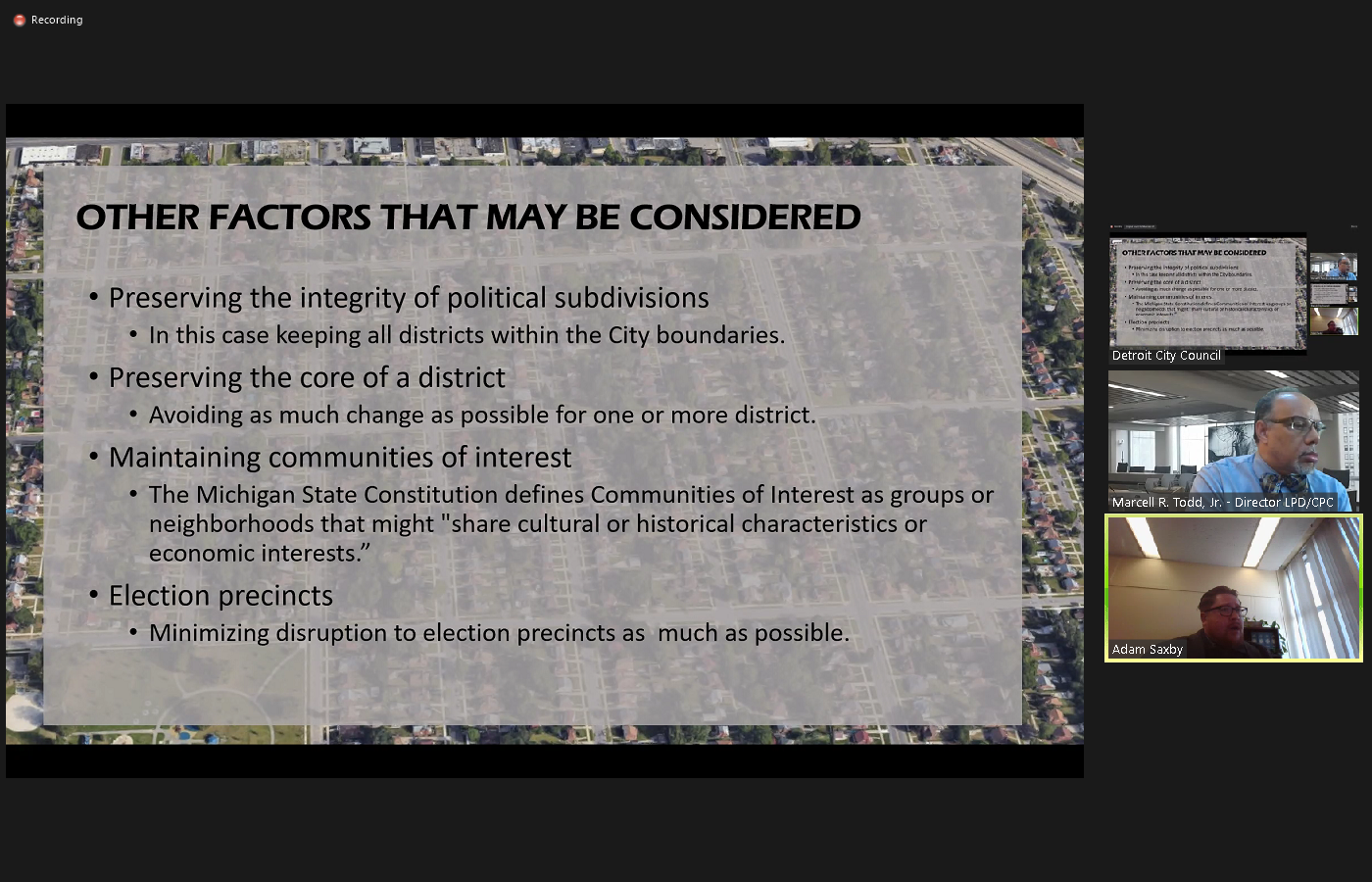
 you, Miss Murphy. Thank you, Madam President. I believe we have moved on from primary considerations and moving on to the following slide the other factors that may be considered Thank you Miss Murphy the other factors that can be considered within that framework of the two primary considerations are preserving the integrity of political subdivisions. And in this case, that just means keeping all districts within the city boundaries, preserving the core of the district that means avoiding as much change as possible for one or more districts as they are already. They already drawn maintaining communities of interest. The Michigan State Constitution defines communities of interest as groups or neighborhoods that might share cultural or historical characteristics or economic interests and as I mentioned, finally, minimizing disruption to election precincts as much as possible. And this is really to help ensure a smooth and orderly election. These are the factors that director Todd's group was counseled to factor in in various ways. Within the within the league within the framework of the primary considerations, always keeping that those primary considerations at the top of their minds and within that five to 5% on either side of the perfect of the average population, the maps before you are what what you see as a result of that. I'll let Director to speak to the specifics of the maps and what factors may have been emphasized and various options, but that that is the legal framework that we the lot Department provided.
+2
you, Miss Murphy. Thank you, Madam President. I believe we have moved on from primary considerations and moving on to the following slide the other factors that may be considered Thank you Miss Murphy the other factors that can be considered within that framework of the two primary considerations are preserving the integrity of political subdivisions. And in this case, that just means keeping all districts within the city boundaries, preserving the core of the district that means avoiding as much change as possible for one or more districts as they are already. They already drawn maintaining communities of interest. The Michigan State Constitution defines communities of interest as groups or neighborhoods that might share cultural or historical characteristics or economic interests and as I mentioned, finally, minimizing disruption to election precincts as much as possible. And this is really to help ensure a smooth and orderly election. These are the factors that director Todd's group was counseled to factor in in various ways. Within the within the league within the framework of the primary considerations, always keeping that those primary considerations at the top of their minds and within that five to 5% on either side of the perfect of the average population, the maps before you are what what you see as a result of that. I'll let Director to speak to the specifics of the maps and what factors may have been emphasized and various options, but that that is the legal framework that we the lot Department provided. Speaker 28
Thank 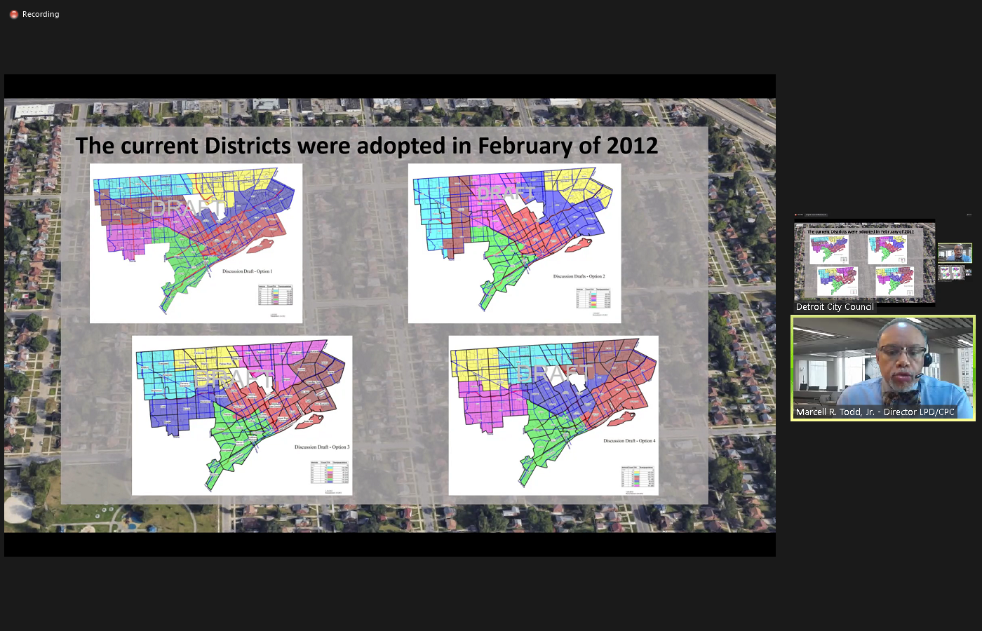
 you, Mr. Saxby. Thank you, Madam Chair continuing on. Before you now are the images of the options that were provided to the Detroit City Council back in 2012. When the districts were initially created, we attempted again, given that this was our first attempt at creating districts to provide counsel with options based upon some basic approaches. The first approach was to look at dividing the city up going if you will, on a horizontal plane is essentially setting up districts on an East West approach. The second one in the upper right hand corner was to look at them in a north south orientation by enlarge, then the option that you see immediately in the lower left hand corner was a hybrid approach of the first two. And then the last one was the looking at an approach just a pure clustering and what we recognized in that instance, was that the central district, the one shaded in blue, would always be completely and totally subject of the other districts, given that it would not have its own fixed boundary. For this and number of other reasons. The city council at that point in time elected to go with the option three, the hybrid, again in the lower left corner. Next slide, please Miss Murphy.
+3
you, Mr. Saxby. Thank you, Madam Chair continuing on. Before you now are the images of the options that were provided to the Detroit City Council back in 2012. When the districts were initially created, we attempted again, given that this was our first attempt at creating districts to provide counsel with options based upon some basic approaches. The first approach was to look at dividing the city up going if you will, on a horizontal plane is essentially setting up districts on an East West approach. The second one in the upper right hand corner was to look at them in a north south orientation by enlarge, then the option that you see immediately in the lower left hand corner was a hybrid approach of the first two. And then the last one was the looking at an approach just a pure clustering and what we recognized in that instance, was that the central district, the one shaded in blue, would always be completely and totally subject of the other districts, given that it would not have its own fixed boundary. For this and number of other reasons. The city council at that point in time elected to go with the option three, the hybrid, again in the lower left corner. Next slide, please Miss Murphy. 
Speaker 28
So there were some minor tweaks, if you will, to that original concept in order to ensure that it aligned with all of the factors that Mr. Saxby alluded to earlier. But quite chiefly among that, among those being the population and as I'll get to later, the voting districts, what you're looking at now are the current city council districts with the applied census data from 2020. And you will note here, the changes in population and the next slide will detail that even further. I'm sorry, Miss Murphy if you could go back. But did want to indicate here on the lower left side of this lower right hand side of the screen, as Mr. Saxby indicated earlier, based upon our population from the contested 2020 census, the median population for seven districts would be 91,400 the plus or minus 5% range would mean that the top the highest total population per district would be 95,970 and the lowest would be 86,830. So those are the ranges that is that is the range in which the population can fall. In most of our efforts, as alluded to we try to make the populations as close as possible, but there is the flexibility as indicated here. This would mean even as a caller indicated earlier, that there could be as is the case with the current or I should say, as was the case, when the current districts were adopted, that there were even greater fluctuations between the numbers from district to district. Next slide please. Here you can see those changes. You have the populations from 2000 from the 2010 census and the first column second, showing you the populations as a portion from the 2020 census and then you can see the percentage decrease. This is the greatest factor in what we are challenged with here. As you will note, districts three and four in particular, having had the greatest losses 19.95% loss in population for district four and a 16.84 decrease for district three. Similarly, districts five and six were also high in their losses. And then we see districts one and two having the least decrease and then immediately followed by district seven, but it is these population changes. Again, if you focusing your attention back on the apportionment of the 2020 census on the existing on the upon the existing boundaries. You can see how  far these numbers are from that 91,400 median population and the change if you will, that is necessary for each district in order to bring them into balance to bring them as close to those numbers as possible or again otherwise within that range from 86,832 95,970. Next slide. Thank you. This slide shows the new voting precincts. Unfortunately, one of the reasons why we are delayed behind our original timeline has to do with the challenges that elections had with restructuring the voting cities voting precincts, the grid upon which the previous or I should again say the current city council districts was based is that of the voting precincts while we do not have to strictly followed by them. Having to split precincts creates a problem for Election Commission's and can create a great deal of confusion. Certainly I will let our colleagues at elections speak more specifically to that. So again, this is the grid that the excuse me that the boundaries are based upon we can't just follow any streets. We have to follow the streets that are aligned or our current with the configuration of voting precincts. This map depicts if I am correct 400 voting
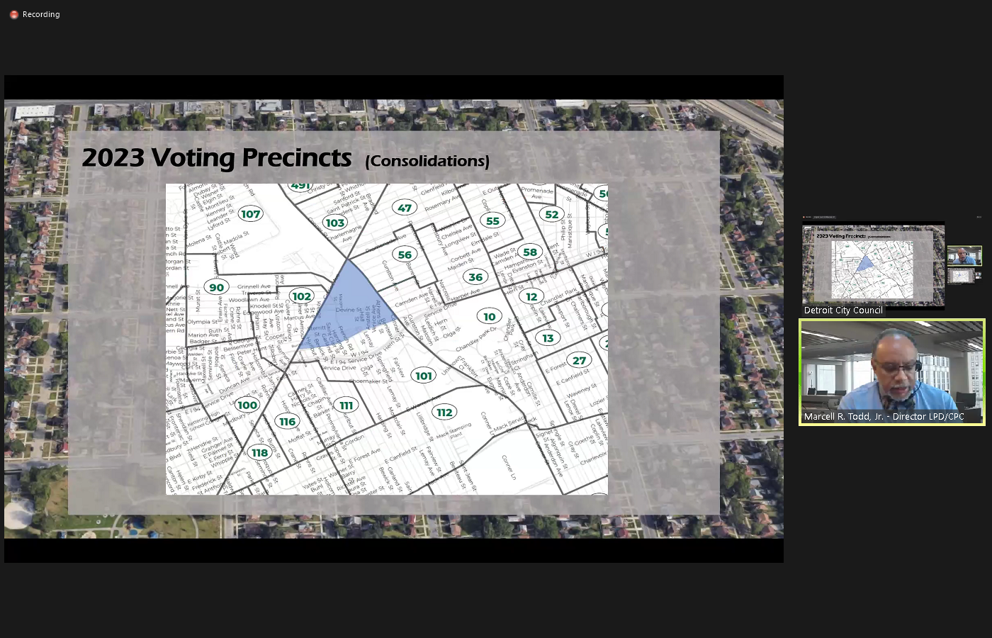
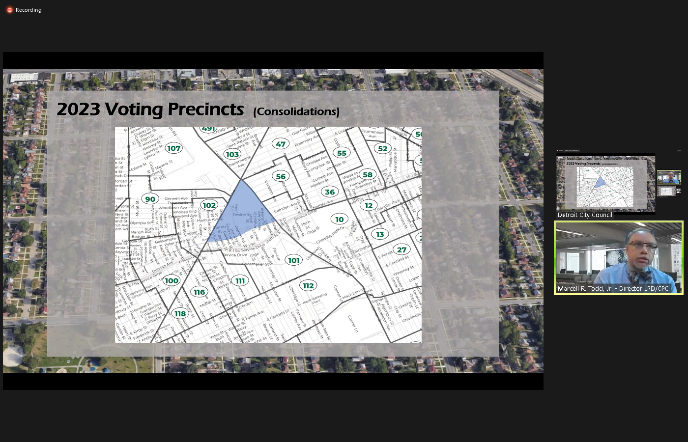 precincts. Next slide please. This next slide shows the populations that have been a portion to each of those districts. This is how we are putting the puzzle pieces together if you will to come up with the varied options that we have presented. The populations again are ascribed to each of those voting districts when the current districts were established. We were working with 450 Some precincts we are now working with less again due to our changing demographics and other operational issues faced by elections. Next slide. This slide is indicative of how the current effort is impacted by those changes in the election. Or I'm sorry, voting precincts This slide shows a shaded area that was precinct 101 under the 2012 or resulting from the 2010 sentence and the 2012 adoption of districts. This precinct provided the one of the boundaries for district three and we're using this as an actual example. If you go to the next slide you will see how under the current precincts voting precincts district one has been consolidated district 101 has been consolidated and is now a larger district. This means that that former boundary for district three which ran along
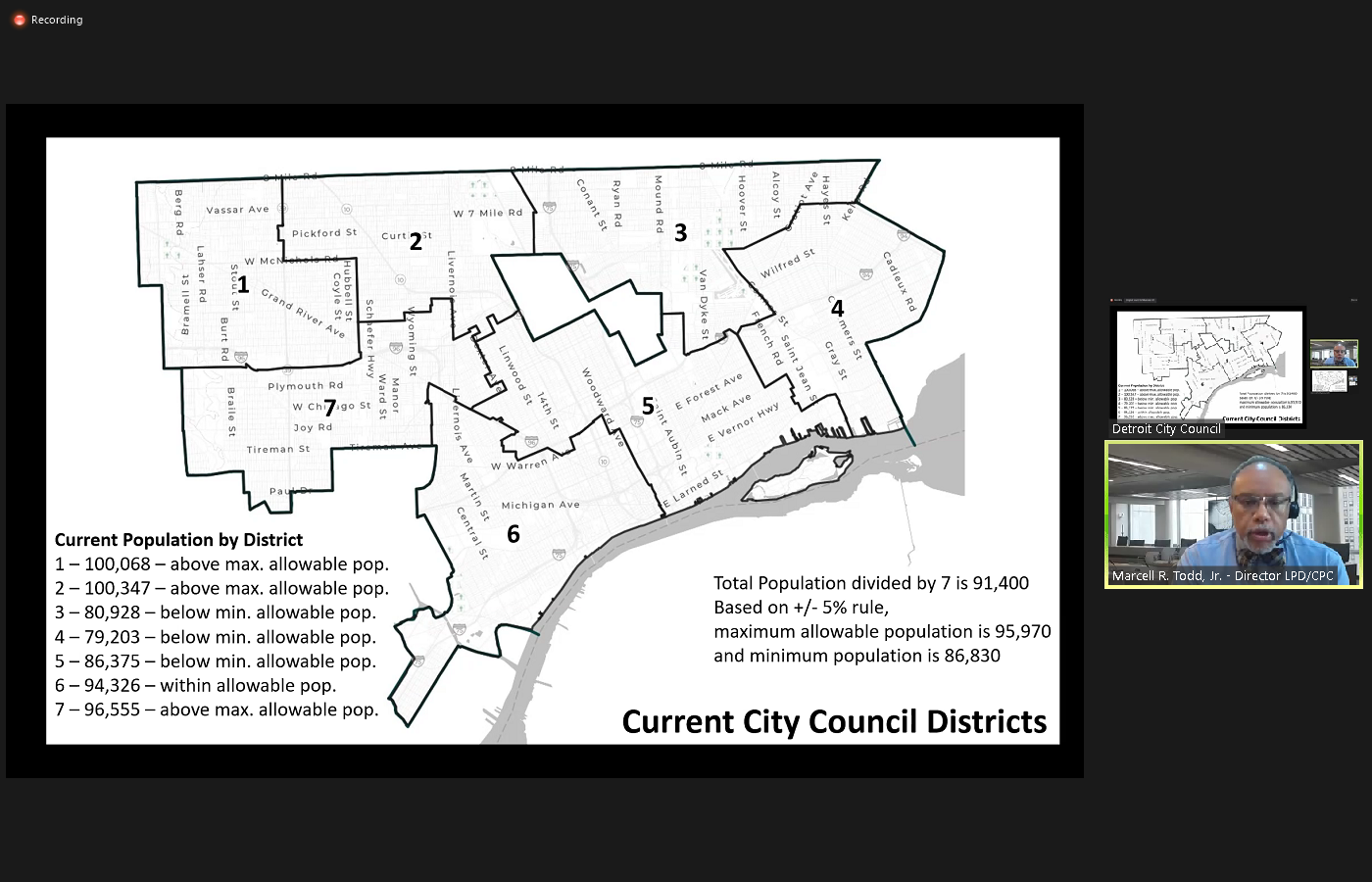
 Harper is no longer available. This happens again in several other instances around the city where due to the consolidation or merger of precincts, the lines have changed and some again are no longer available from the grid that we were working with in 2012. So again, the precincts the voting precinct grid that we're working with today has 50 fewer precincts from which to derive your new read district boundaries. Next slide. So, again, the proposed districts that we have come up with, again, the initial three and the two that have been added as a result of our submission to your animal body yesterday, looking to work with all of those factors. Next slide. Here again, as a reminder is what we're starting with today with the current districts and the populations as apportioned. Next, option one thought and again, let me repeat myself just to make it clear, we applied all of the requirements by law in the preparation of each of these districts. But in light of those factors, as explained by Attorney Saxby, we took the opportunity to sort of emphasize maybe one thing over another in order to come up with different variations. In some instances, we also change the starting point of our effort moving from, say the northwest side of the city, to the south, east side of the city, or again starting in the center to try to work out and analyzing the differences in what resulted. So if you go to the next slide, Miss Murphy, what I'd like to point out, as I alluded to earlier is that when you look at all of the districts, you will note
+1
far these numbers are from that 91,400 median population and the change if you will, that is necessary for each district in order to bring them into balance to bring them as close to those numbers as possible or again otherwise within that range from 86,832 95,970. Next slide. Thank you. This slide shows the new voting precincts. Unfortunately, one of the reasons why we are delayed behind our original timeline has to do with the challenges that elections had with restructuring the voting cities voting precincts, the grid upon which the previous or I should again say the current city council districts was based is that of the voting precincts while we do not have to strictly followed by them. Having to split precincts creates a problem for Election Commission's and can create a great deal of confusion. Certainly I will let our colleagues at elections speak more specifically to that. So again, this is the grid that the excuse me that the boundaries are based upon we can't just follow any streets. We have to follow the streets that are aligned or our current with the configuration of voting precincts. This map depicts if I am correct 400 voting +3
precincts. Next slide please. This next slide shows the populations that have been a portion to each of those districts. This is how we are putting the puzzle pieces together if you will to come up with the varied options that we have presented. The populations again are ascribed to each of those voting districts when the current districts were established. We were working with 450 Some precincts we are now working with less again due to our changing demographics and other operational issues faced by elections. Next slide. This slide is indicative of how the current effort is impacted by those changes in the election. Or I'm sorry, voting precincts This slide shows a shaded area that was precinct 101 under the 2012 or resulting from the 2010 sentence and the 2012 adoption of districts. This precinct provided the one of the boundaries for district three and we're using this as an actual example. If you go to the next slide you will see how under the current precincts voting precincts district one has been consolidated district 101 has been consolidated and is now a larger district. This means that that former boundary for district three which ran along 
+2
Harper is no longer available. This happens again in several other instances around the city where due to the consolidation or merger of precincts, the lines have changed and some again are no longer available from the grid that we were working with in 2012. So again, the precincts the voting precinct grid that we're working with today has 50 fewer precincts from which to derive your new read district boundaries. Next slide. So, again, the proposed districts that we have come up with, again, the initial three and the two that have been added as a result of our submission to your animal body yesterday, looking to work with all of those factors. Next slide. Here again, as a reminder is what we're starting with today with the current districts and the populations as apportioned. Next, option one thought and again, let me repeat myself just to make it clear, we applied all of the requirements by law in the preparation of each of these districts. But in light of those factors, as explained by Attorney Saxby, we took the opportunity to sort of emphasize maybe one thing over another in order to come up with different variations. In some instances, we also change the starting point of our effort moving from, say the northwest side of the city, to the south, east side of the city, or again starting in the center to try to work out and analyzing the differences in what resulted. So if you go to the next slide, Miss Murphy, what I'd like to point out, as I alluded to earlier is that when you look at all of the districts, you will note Speaker 28
in the case of district one district seven, District Four, District Six in particular, they really have fixed boundaries that greatly limit the flexibility if you will, with what can be done. They are fixed boundaries that are established by the borders of the city, eight mile which also of course it's district two and district three, and then of course the river on the south side is what provides additional fixed boundary for districts 545 and six. One of the other things that is unique about the city of Detroit when you go back to the issues of being contiguous and compact is the shape of the city itself, which is odd and the fact that it also has two other cities within it, providing additional fixed boundaries with which to work these factors again serve to further limit what we can do along with that grid. So again, with this first option, what we look to do was simply maximize the population. I'm sorry, we look we focused here on excuse me, we focused here on trying to get equal populations and letting that primary factor really dictate what happens here trying to go for as little change as  possible with the boundaries but again, facing the reality of what we're looking at with districts four, and three, having lost the most population and those being the districts that would warrant again, along with five and six, the most change because of the additional population that would be necessary to bring them into balance. So again, this one focused on that equal change. Again, trying to have equal papi as equal populations as possible from district to district. Next slide, please. And here with option two, we were stressing I'm sorry, now, chanting, we were stressing. We were stressing equal populations over boundaries with this option. We were stressing equal population but trying to maintain as much of the boundaries of the existing with the previous item again, sorry for the confusion there. Option one. Look to look to prioritize equal populations, but try to go for as little change as possible with the existing boundaries. Option two looks to prioritize the equal population over the boundaries. Next slide please. So here again, you see the results of taking this approach. In these first two approaches, we really were still trying to adhere as closely as possible to the original districts, but again, responding to what the changed part with the change in population warrants as well. As what to change in voting precincts. With regard to these and all of the options, again, there are detailed maps for each district that show the changes and we will show a model of that again at the very end of the presentation. Now I'm just trying to quickly walk through each of the five options that we have provided and give you a brief overview. One of the things that we recognize when it comes to the lesser populations that have resulted in districts three and four. When you look at these two, when you look at this map you can see when it comes to trying to add populations to district three and four, well, they could logically take from one another, but in terms of their adjacencies in order for three to increase in population it has to take from two in order for four to increase in population it has to take in five, take from five and then that creates a domino effect impacting the other districts. If you could advance to the next slide, Miss
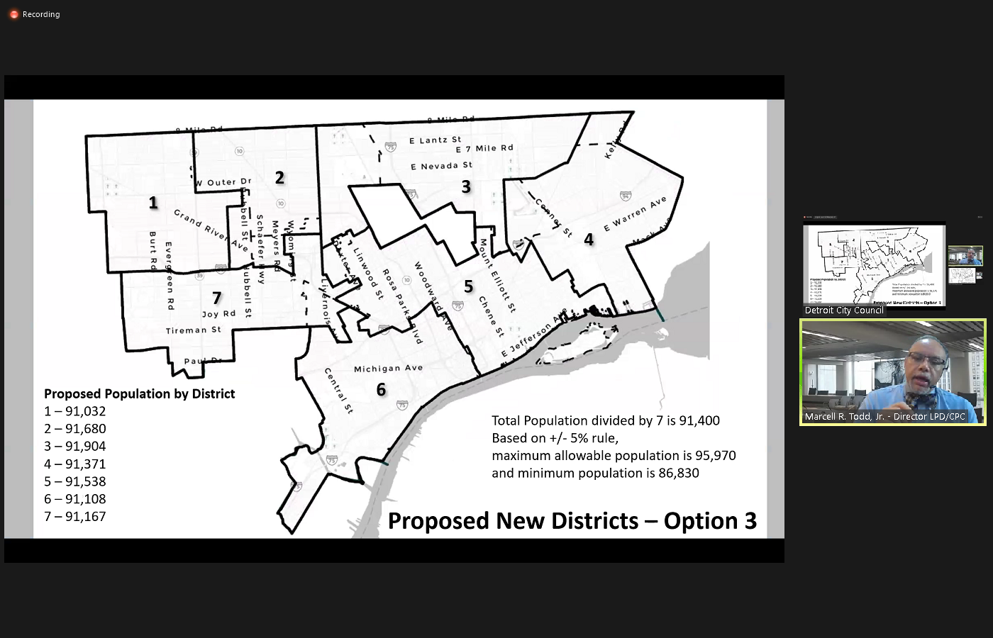
 Murphy, option three was the first one where we look to sort of try to maintain as much of five as we could in light of that reality. And it resulted in next slide. what amounts to a counterclockwise shift, if you will, going from left to right up and around, meaning that District Four took from district three and district three then took from District Two in order to be able to bring it into balance. So again, in terms of approach, we were trying to maintain as much as five as we could and to see how this particular approach would impact the district the distribution of the districts. So this is what gave us option three. Next slide please. In option four, we looked to try to spread the impact if you will, more equally across all of the districts recognizing that, again, recognizing all the limitations in terms of fixed boundaries, again, chiefly still population as well as the voting precincts. Next slide please. Here, you can see where there is a little bit more balance, if you will, in terms of the amount of change that each district is undergoing, or alteration as we try again, to sort of equalize to the extent that the populations will allow us to do so the impact of redistricting, it is important to note that each of the populations assigned to these voting precincts. When you take a closer look at them, you can see that no matter the geography, there is great variance. Some are more densely populated. Others are less densely populated. No matter what the size of that particular no matter what the area geographic area of that voting precinct happens to be. Again, we will use this option to show you a more detailed
  review of the impacts to the changes that option four presents. Next slide. Option five allows for more of a northward expansion of district five. Again, as I indicated when when I presented the way in which these current districts were derived, when you look at all of the fixed boundaries of the city's borders, and you look at the surrounding Next slide, please if you look at how again, districts 67124 And five, really, again, are based upon the perimeter of the city, district five, sort of as a natural function of bringing those other districts into balance is sort of left in the leftover position, if you will, I don't mean to minimize it in any way. But given that it has the least fixed boundary by virtue of the river, it is impacted by all of the changes that are necessitated. To bring the other districts into balance. So it is a district that can again be created, if you will, a somewhat by default. Again, this is why we attempted different approaches ones where we were looking at trying to maintain as much or some portion of certainly districts in doing so not just from a geographic basis, but recognizing some of those concerns expressed by the citizenry. And again, as indicated by Attorney Saxby in terms of the other considerations that being maintaining committees, maintaining communities, maintaining ethnic groups trying to maintain to the extent that we could the core area of each of the districts, but again, I must emphasize the incredible challenge that our population losses have presented in trying to do that at this time. With that, as I am getting a little bit weak on my voice. I would like to yield the floor to miss Murphy to walk you through the next series of slides that will again detail
+1
possible with the boundaries but again, facing the reality of what we're looking at with districts four, and three, having lost the most population and those being the districts that would warrant again, along with five and six, the most change because of the additional population that would be necessary to bring them into balance. So again, this one focused on that equal change. Again, trying to have equal papi as equal populations as possible from district to district. Next slide, please. And here with option two, we were stressing I'm sorry, now, chanting, we were stressing. We were stressing equal populations over boundaries with this option. We were stressing equal population but trying to maintain as much of the boundaries of the existing with the previous item again, sorry for the confusion there. Option one. Look to look to prioritize equal populations, but try to go for as little change as possible with the existing boundaries. Option two looks to prioritize the equal population over the boundaries. Next slide please. So here again, you see the results of taking this approach. In these first two approaches, we really were still trying to adhere as closely as possible to the original districts, but again, responding to what the changed part with the change in population warrants as well. As what to change in voting precincts. With regard to these and all of the options, again, there are detailed maps for each district that show the changes and we will show a model of that again at the very end of the presentation. Now I'm just trying to quickly walk through each of the five options that we have provided and give you a brief overview. One of the things that we recognize when it comes to the lesser populations that have resulted in districts three and four. When you look at these two, when you look at this map you can see when it comes to trying to add populations to district three and four, well, they could logically take from one another, but in terms of their adjacencies in order for three to increase in population it has to take from two in order for four to increase in population it has to take in five, take from five and then that creates a domino effect impacting the other districts. If you could advance to the next slide, Miss +3
Murphy, option three was the first one where we look to sort of try to maintain as much of five as we could in light of that reality. And it resulted in next slide. what amounts to a counterclockwise shift, if you will, going from left to right up and around, meaning that District Four took from district three and district three then took from District Two in order to be able to bring it into balance. So again, in terms of approach, we were trying to maintain as much as five as we could and to see how this particular approach would impact the district the distribution of the districts. So this is what gave us option three. Next slide please. In option four, we looked to try to spread the impact if you will, more equally across all of the districts recognizing that, again, recognizing all the limitations in terms of fixed boundaries, again, chiefly still population as well as the voting precincts. Next slide please. Here, you can see where there is a little bit more balance, if you will, in terms of the amount of change that each district is undergoing, or alteration as we try again, to sort of equalize to the extent that the populations will allow us to do so the impact of redistricting, it is important to note that each of the populations assigned to these voting precincts. When you take a closer look at them, you can see that no matter the geography, there is great variance. Some are more densely populated. Others are less densely populated. No matter what the size of that particular no matter what the area geographic area of that voting precinct happens to be. Again, we will use this option to show you a more detailed 
+1
review of the impacts to the changes that option four presents. Next slide. Option five allows for more of a northward expansion of district five. Again, as I indicated when when I presented the way in which these current districts were derived, when you look at all of the fixed boundaries of the city's borders, and you look at the surrounding Next slide, please if you look at how again, districts 67124 And five, really, again, are based upon the perimeter of the city, district five, sort of as a natural function of bringing those other districts into balance is sort of left in the leftover position, if you will, I don't mean to minimize it in any way. But given that it has the least fixed boundary by virtue of the river, it is impacted by all of the changes that are necessitated. To bring the other districts into balance. So it is a district that can again be created, if you will, a somewhat by default. Again, this is why we attempted different approaches ones where we were looking at trying to maintain as much or some portion of certainly districts in doing so not just from a geographic basis, but recognizing some of those concerns expressed by the citizenry. And again, as indicated by Attorney Saxby in terms of the other considerations that being maintaining committees, maintaining communities, maintaining ethnic groups trying to maintain to the extent that we could the core area of each of the districts, but again, I must emphasize the incredible challenge that our population losses have presented in trying to do that at this time. With that, as I am getting a little bit weak on my voice. I would like to yield the floor to miss Murphy to walk you through the next series of slides that will again detail Speaker 28
or  at least will detail how option four was put together and allow the council and the public to see when you look at the subsequent maps, the changes per city council district. And I hope that that is clear. Certainly Miss Murphy will make it clear.
+1
at least will detail how option four was put together and allow the council and the public to see when you look at the subsequent maps, the changes per city council district. And I hope that that is clear. Certainly Miss Murphy will make it clear. Speaker 30
That  all about that I will try Jamie Murphy of the City Planning Commission staff and legislative policy division. One of the things we really have struggled with I think with these proposed changes is depicting them in a way so that everyone can kind of understand what's proposed. Obviously, when you look at a whole map of the city that's really big and really detailed and it's hard to see where the proposed changes are. So for each of the options we made, like a close up of each district, and so here with the proposed district one from option four, you can see the heavy black line would be the new proposed boundary. And then the area highlighted in red is in the current district one but would be eliminated in this particular option for the new district one. And then the dark blue area here is an area that isn't currently in district one, but it would be added in this current option. So then it goes through each district. Here's District Two, it's quite a bit more complicated than district one. Of course, it's proposed to lose this strip over here used to Woodward, a little chunk
  adjacent to Highland Park South of Finkle another chunk over here and your Ardmore and Puritan. And then that little chunk that district one gains over here near the Southfield freeway, and then they only have two areas that they gain. little square here at Mike Nichols and Ardmore. And then another here that they gain from district seven. And then it just goes through each district the same. I won't go through every single part of every one but you can kind of see how like there's a give and take. So district two lost this area between Jana and Woodward. So district three gains at this big triangle here District Four loses on the west side of Gratiot and district three gains that and moving on district four very similar. You can see the triangle that district three gains here on the other side of Gratiot is eliminated from District Four. So these were just meant to try to help everybody understand especially people that don't look at maps every day. What exactly the proposals are to get rid of and to gain for each district. So again, I'll just flip through these without going into extreme detail.
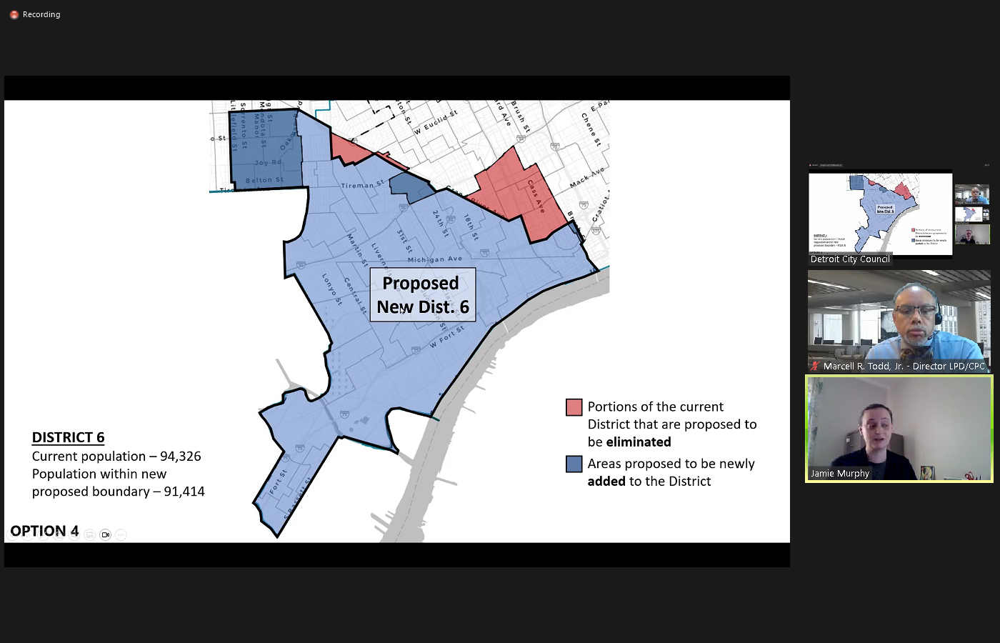
 But you can see district five has the most dramatic changes probably in this this option. And most of the options, losing a big portion of their east side and gaining some big portions on the west side. And then District Six, of course doesn't change very much since their population was as close to the median as any district and then save district seven like they gain based on the other districts that had to lose and then lose based on the districts that have to gain.
+1
all about that I will try Jamie Murphy of the City Planning Commission staff and legislative policy division. One of the things we really have struggled with I think with these proposed changes is depicting them in a way so that everyone can kind of understand what's proposed. Obviously, when you look at a whole map of the city that's really big and really detailed and it's hard to see where the proposed changes are. So for each of the options we made, like a close up of each district, and so here with the proposed district one from option four, you can see the heavy black line would be the new proposed boundary. And then the area highlighted in red is in the current district one but would be eliminated in this particular option for the new district one. And then the dark blue area here is an area that isn't currently in district one, but it would be added in this current option. So then it goes through each district. Here's District Two, it's quite a bit more complicated than district one. Of course, it's proposed to lose this strip over here used to Woodward, a little chunk +1
adjacent to Highland Park South of Finkle another chunk over here and your Ardmore and Puritan. And then that little chunk that district one gains over here near the Southfield freeway, and then they only have two areas that they gain. little square here at Mike Nichols and Ardmore. And then another here that they gain from district seven. And then it just goes through each district the same. I won't go through every single part of every one but you can kind of see how like there's a give and take. So district two lost this area between Jana and Woodward. So district three gains at this big triangle here District Four loses on the west side of Gratiot and district three gains that and moving on district four very similar. You can see the triangle that district three gains here on the other side of Gratiot is eliminated from District Four. So these were just meant to try to help everybody understand especially people that don't look at maps every day. What exactly the proposals are to get rid of and to gain for each district. So again, I'll just flip through these without going into extreme detail. +2
But you can see district five has the most dramatic changes probably in this this option. And most of the options, losing a big portion of their east side and gaining some big portions on the west side. And then District Six, of course doesn't change very much since their population was as close to the median as any district and then save district seven like they gain based on the other districts that had to lose and then lose based on the districts that have to gain. Speaker 28
Thank you, Miss Murphy, Madam President, city council. This completes the formal portion of our presentation would like to provide opportunity for Mr. Saxby. Should he have anything to add? Or certainly Mr. Whittaker or Ms. Barkley, but prior to that, since we do have elections on the line, and we did not get the chance to formally coordinate I'm not sure if there's anything that they need to add at this time.
President Sheffield
Thank you, Director tat to the clerk's office.
Speaker 31
Good afternoon. To the chair. This is Daniel Baxter and present with me is Detroit City Clerk Janice Winfrey. Director Gina Avery and Deputy Director Georgia zoos. Just want to say to Mr. Todd and attorney Saxby You did a fine job in the work that you've done. I thank you so much for honoring our boundary lines. And we are very much satisfied with the information that you provided. But we know ultimately the final decision rests upon the Detroit City Council. So thank you so much for the opportunity, but we we think that you've done a fine job
Speaker 32
and I just like to add in layman's term, if I may, because you respect our boundaries. It costs less confusion at the precinct. And that's so important for us. We do not want our voters to be disenfranchised in any way. So thank you.
President Sheffield
Great thank you. Thank you, city clerk and thank you, Director Todd for that very thorough presentation. We appreciate the work and effort that you all put into these proposed maps. And we will open it up now for any questions from my colleagues on the presentation that has been presented thus far. Any questions or comments? Madam President, yes, Councilmember Santiago Ramiro. Thank you, Madam
Speaker 8
President, through you to Mr. Todd, Dr. Todd I stepped away briefly to use the restroom. It's been a long day. But when I came back, we were looking at option four through throughout all the districts. Is this the one and again I might have missed this. Is this the one that you are recommending to us to approve? And as a follow up, is there a recommendation for any of these maps?
Speaker 28
The chair to member Santiago Romero. Given that we are as we indicated when this request was made two weeks ago, we thought two weeks would be enough time for us to prepare at least two options. It was just completed over the weekend. And we are still evaluating it. But to answer your question, we do believe that based upon some of the additional information, those additional considerations, again that Mr. Saxby mentioned that we think this is probably the most responsive, given our circumstance. It could well be the basis for further tweaks. If we have a favorite, I guess I might say this is it. But again, what we are faced with is this need to be objective, as again has been alluded to and try to follow the numbers. We do believe that it that five certainly has some interesting components and then it may have some other things that are deficient again as the others as is the case with the others but to answer your question, I think four is a favorite. Based upon what we know today.
Unknown Speaker
Madam President Thank you. Thank you, Director Todd. Thank you, Madam President.
President Sheffield
Thank you, Member Santiago and Miro. Any additional questions? All right. So I know that this was just the first of many public discussions that are forthcoming. And Mr. Todd just kind of moving forward next steps. I know that a lot of my colleagues along with myself, we're going to be looking forward to hosting kind of individual meetings throughout our district, maybe during recess virtually or in person to allow the public to react to the five options that we have. And then when we come back from recess in January, you want us to kind of narrow it down to just two proposals. Is that which, yes,
Speaker 28
madam president, if it's possible to narrow it down to one that would be preferred, but obviously we recognize the many variables that are in play and the community's response. So we would otherwise suggest no more than two. Moving forward and quickly if I may, again, to the extent that you've just received these items and we know that you need time to further evaluate them. Again, if prior to your recess. There is the desire for us to create the alternatives to the options we've provided or variants. We look forward to receiving that direction or again to even try to create a sixth option. I will just say this with regard to the work that we've done, a brand new sixth option I can only suggest would be would would present some more severe changes if you will, as to what we've given variations on the five that we provided, I think certainly possible, but a completely different sixth option might again present a very different configuration than what you have in the in the five options provided thus far.
President Sheffield
Okay, all right. Well, we appreciate the presentation. Yes, Councilmember.
Speaker 8
Thank you, Madam President. Just want to for the record. Note that our office did reach out to residents and district leaders via newsletter November 3 and the 10th Regarding redistricting, and for District Six residents to save the date. December 6 is when we're looking to have this discussion in the districts. Thank you, Madam President. All right. Thank you so much, Council Member.
President Sheffield
All right. Is there a president? Yes.
Speaker 28
I'm sorry. Just quickly, we look forward to supporting those engagements that the body has a whole or individual council members do set up will do so to the best of our availability with staff and provide the information as as needed. I was seeking one direction. I apologize, Madam President. If you if this honorable body would again per report like us to formally post this information on your website, or the city's website so that it can be viewed? Yes,
President Sheffield
yes. Do you need a motion for us to do that or just the direction to go ahead and post all of the maps that have been proposed? To date so that the public can view
Speaker 28
unless Mr. Whittaker objects or the parliamentarian, Dr. Powers, I think a direction to do so as efficient
President Sheffield
as efficient. All right, thank you. So we will have that posted online. It should be a motion is there a motion to do so. Right? Here are no objections. All of the maps that have been proposed as part of the five maps will be posted online for the public to view Are you do you have an option or any way or any ability to collect feedback via any type of way online from residents or is it just during our public comment time and directly to council members?
Speaker 28
Madam President, I think we would prefer trying to receive it through the members of this honorable body to the extent that you are ultimately the decision makers, but we can certainly ask of, of do it. If we could provide some commentary mechanism as well.
President Sheffield
All right, we appreciate you. Thank you so much, Director Todd, and if there is nothing else to come before us, we will adjourn. Just a reminder that we do have a district or evening council meeting this evening at 7pm. And so I know it's been a long day but we are going to keep going and head over to District Four for the evening council meeting in councilmember Johnson's district. So thank you all for your patience. If there's nothing else to come before us. This meeting will stand adjourned.