Loading...
Highland Park City Council
Speaker 1
Evening and welcome to regularly scheduled Highland Park City Council meeting scheduled for today. Monday, Monday, June 16, 2025, at 7pm if you will be kind enough to call the roll for today's meeting. Madam Deputy Clerk,
Speaker 2
Councilman ashafi Press it Councilwoman Martin here, Councilwoman Manica here. Council proton Robinson, Council President Thomas here.
Speaker 1
Thank you very much. We have a coring to meet the core on the meeting I can proceed. Next item would be the approval of today's agenda. We just received two walk on items from the legal department, one relating to the summer youth employment resolution. The second would be the resolution to purchase two new police vehicles. Should these items be adopted the resolution on summer employment, ideally go under item seven, becoming 7b under the administration and the police department, purchase of a vehicle will become item 12 after
Unknown Speaker
public works.
Speaker 3
Yeah, I don't think you access anything wrong here. Council
Unknown Speaker
President, I'm sorry, sir,
Unknown Speaker
I'm sorry I could hear you, I
Speaker 3
said, I said, I get we're trying to put them somewhere, but we know sorry.
Speaker 1
Is that the play is that the pleasure Council, it's at the I was making a suggestion, but it's at the pleasure Council whether or not we adopt the agenda as it is, or add these items so city council, having received your packet in the current agenda, and also, having received the suggested walk on items, the Chair will wait and entertain a motion
Unknown Speaker
on today, Mr. President, where are
Speaker 1
we putting as the last item that will be 12 and then the The other recommendation was the rearrangement of the items under community development, where we would replace the we would switch the items, where Item B will become a and a will become b. It's just moving them within the
Unknown Speaker
current
Speaker 3
is there a reason why this resolution here says resolution to approve agreements between Detroit Wayne Integrative Health Network and the city of Highland Park Summer Youth Program. Is that two things or one thing? Yeah, that d1
Speaker 1
that sounds like one. It's a resolution to approve the agreement between Wayne integrated health and the city of Highland Park. It sounds like one
Speaker 3
thing. Okay, hold a second. It says the Integrated Health Network and the city of Highland Park Summer Youth Program. That sounds like two items
Speaker 1
to me. I think the one group is paying for it and the other group is benefiting.
Unknown Speaker
What this amendment budget is saying.
Speaker 1
I guess that's something to be deliberated, but it seems pretty straightforward. If there
Speaker 3
any straight Council President, okay, straight forward to you. I get it.
Speaker 1
Okay, so at this point now, right, I'm looking to entertain a motion to
Unknown Speaker
approve the agenda. Miss Manica, would you please?
Speaker 4
I will make the motion, but I just want to make sure we are we're trying to place that. So it's placing summer youth under making it number seven or under number seven, making it B, 7b making it 7b under administration,
Unknown Speaker
yes, ma'am, and then
Speaker 4
the police vehicles. We just going to make 12 altogether at the bottom, yes, ma'am. And is that? What is that being called?
Unknown Speaker
It's under police. It's the resolution to
Unknown Speaker
approve the purchase of two new vehicles.
Unknown Speaker
No, so it'll be called police,
Unknown Speaker
yes, ma'am, under, under this stuff, Eddie,
Speaker 5
police department. Okay, thank you for the clarity.
Speaker 4
Alright, I moved to approve the agenda with adding two resolutions. The first resolution is resolution to approve agreement between Detroit Wayne integrated health network and the city of Highland Park Summer Youth Employment Program, making that 7b under administration and the second resolution, resolution to approve the purchase of two new police vehicles from Gorno Ford for the Police Department, making that number 12 under police department, and then also, I'm sorry, you're saying something. Okay, then under community development, we're gonna flip a and b, so a now becomes B, which is resolution to approve the rezoning of vacant, vacated parcels adjacent to 13232, Woodward Avenue to transit oriental development, so that now becomes b and then resolution to approve the Vacation of portions of public alley adjacent to 13232, Woodward Avenue for DMC, property management LLC,
Unknown Speaker
making that a
Unknown Speaker
chair. I know that was a lie.
Speaker 1
Chair office a second. We have a motion on the floor by Councilwoman Manica to approve the agenda with the following amendments, adding under Section seven, turning it to 7b that is the resolution for the approval of the Summer Youth Program, and adding, I'm sorry, under item nine, the reversing of the order under Community Economic Development, item B becoming a, as well as Adding under item 12 for the police department, a resolution to approve the purchase of two new police cars. The chair offers a second
Unknown Speaker
questions, concerns,
Speaker 3
to use the one council president, mister, that is one in the same. It looks like two items on this. Okay. Um, resolution. I just wanted to avoid that opinion, because when Council pro Tim did the same thing with her resolutions, they were, they were summarily dismissed because she had more than one item on it, even though they were all tied together, her resolutions were were thrown out. But here we are breaking the rules being or bending the rules to add two items on one resolution. When it's stood at White, it's for the health network and it's for the youth program, and it's two items. I don't care where the argument
Unknown Speaker
is. Miss Monica, go ahead, please.
Speaker 4
So I'm going to go back to that one again, that resolution to approve an agreement between the two that we would be approving, that they could have an agreement between the two of them to provide our youth or provide the city with the funding to Pay the youth for our summer program. So we're not approving them and then approving the youth. We're approving the actual agreement between the two of them to make that happen. Point
Speaker 1
of order, I'm going to read the resolution, the resolution to approve the agreement between the Detroit Wayne integrated health network and the city of Highland Park Summer Youth Program, whereas the city of Highland Park has an interest in promoting the health, safety and welfare of its citizens, and whereas engaging the youth in the community is a positive activity during the summer months, and whereas the city has been awarded monies by Detroit Wayne Integrated Health Network in the amount of $45,000 to fund a summer youth program to allow eligible participants to earn income during the summer while performing safe yet constructive employment activities which are in the best interest of the youth in a community. Now therefore, be it resolved. Further resolved that city of Highland Park approves the acceptance of $45,000 from the Detroit way integrated health network for the funding of the Summer Youth Program. It reads as one thing, in my opinion, mad approach and please. So
Speaker 6
when you said, Money, this cash? Is it a brand, it's the grant that we get.
Speaker 1
Okay, so we have a motion on the floor for the approval of the budget with the amendment specified made by Councilman Manica, supported by the Chair. Madam Deputy Clerk, would you please call the roll on the approval of the agenda?
Speaker 2
Councilman Shafi No. Councilwoman Martin Yes. Councilwoman Manica, yes. Council President Robinson, yes. Council President Thomas
Speaker 1
Yes. Motion carries moving on to Item four, approval of the proposed minutes. These are the in person and virtual workshop minutes for June 2, as well as the in person and virtual regular meeting minutes for June 2, those items will be taken individually City Council. What's your pleasure?
Speaker 4
I move to approve the in person and virtual workshop meeting minutes for June 2, 2025
Speaker 1
motion on the floor by Councilman Manica, the Chair will offer a second, questions, concerns, roll call, vote. Would you please?
Unknown Speaker
Councilman Shafi,
Unknown Speaker
this is for the workshop, right? Yes, yes.
Speaker 2
Councilwoman Martin Yes. Councilwoman Manica Yes. Council pro Tim Robinson,
Speaker 7
no, because we don't really have actual minutes. Never have for the workshop. All we have.
Unknown Speaker
Council President Thomas, yes,
Speaker 1
thank you. Motion carries next the in person and regular, virtual regular meeting scheduled for June 2. City council, what's your pleasure?
Speaker 4
I move to approve the minutes for the in person and virtual regular meeting June 2. 2025
Speaker 1
Sheriff for support. We have a motion on the floor for the approval of the in person and virtual regular meeting scheduled held on June 2,
Unknown Speaker
questions, concerns,
Unknown Speaker
seeing none would you call the roll
Unknown Speaker
please? Councilman Shafi
Unknown Speaker
Yes,
Speaker 2
Councilwoman Martin Yes, Councilwoman Manica Yes. Council Pro Tem Robinson Yes. Council President
Speaker 1
Thomas Yes. Motion carries, we'll turn the floor over to Mayor McDonald so that she may address citizens and council.
Unknown Speaker
Good evening. Everyone. Good evening. Council
Unknown Speaker
President, citizens
Speaker 8
Park, I have a few things. Start with questions that was asked about life.
Unknown Speaker
So if you indulge me,
Unknown Speaker
ma'am, this is your turn. So
Speaker 8
there were some questions concerning the process of how license will be transferred to the city, and what is the process that you've had lawyers as well as engineers, engineers? What is the process of transferring? We know that the city council has to approve donations once we do the transfer, yes, and that is a donation. So if both of those will be coming to you before at the same time, once, in order to transfer, there's a document that has to be completed and finished, and once that document is completed and finished, it will come before you, as well as acceptance of the donation. So that's part of it. Shamika, not here. She said she was on the way. She do have her all of her stuff that was going back and forth. I appreciate you being here to stand in that happens that should be on the agenda in July coming up, so that you can get those transferred over to the city, and city accept them, then they become property of the city, at which time they will be able to move forward with that, as far as the only two to six, I'm going to talk about the cleanup that's coming on June 21 if you are a resident of Iowa Park, this Saturday, there will be a cleanup in the city. We are providing over 16. I just got a car today, two more 18, roll offs, dumpsters in various areas throughout the city. That's the most we've ever had. So please take advantage of it. Let me tell you what's not to be placed in there. You cannot place tires. You cannot place what is it destruction materials. Cannot place anything that has one of those ion batteries, like computers or anything like that. And also cannot place anything to do with painting, like paint containers, things like that. Nothing to that effect. If you go in, this would be a great opportunity for you. Look in your backyard, look behind your house, because the oldest road is real. And it's not that the city, they came through the alley. Their part, our part is to come through the middle of the alley. Here, I've been out for the last few days, driving by, looking at things going up the downstream, and a lot of people have overgrowth off of their fence or off of their garage, which is part of your property. This is a good time to get that cut down and take it to the dumpster, because you can put those in so tell your neighbors, tell your friends. Tell everybody listen. If you can't have the overgrowth, keep going on in the alleys and then asking us, asking the city to come cut down some it's definitely the top of the homeowner if it's adjacent to your fence and adjacent to the back of your garage. So get with your neighbors here, with your streets. Say, Hey, let's have an alley. We do come through the alley and do the middle, but the part that the Long Street was responsible. Now, let me tell you, there is an ordinance. People are getting very tired, but the ordinance says you are responsible for that, and you and we're going to give you at least 30 days to get that down before they start too. Because what happens is, it draws a lot of rodents. It draws a lot of animals. I see somewhere where there was toilet so through behind somebody's house, up up against their fence, hiding in the bush. And that's that's not so please take pride in your property. You're a renter. Tell your landlord, listen, you can't get out here cutting stuff down because we can get rid of the animals, if we can get rid of debris. Back
Unknown Speaker
Summer Music Series.
Speaker 9
We have a summer music series coming up at the Rec Center
Speaker 8
on every Wednesday evening, from six to eight at the Rec Center right there on midnight street, there's a stage getting ready to start using that little stage that was donated to the city, and it's time that we started using so July 2 is July 9 is jazz. July 16 is hip hop. July 23 is house, techno. There'll be DJ for that, and July 3 against Boston. So come on out lawn chairs. Come sit down, enjoy the music. It's only two hours, six to eight, and do go to downtown, to the repo. You still got time to get down and see the main acts anyway.
Unknown Speaker
Want to talk about, I got a good report this week.
Unknown Speaker
We are in the best financial situation we've been in in 25
Speaker 8
I mean, we have money to blow now. We have been struggling and and my staff tell you we're not spending recklessly, as people put out, and our audit was the best audit in a long time. So no, the financial situation here in Highland Park is improving. It's going to keep improving as long as we keep doing what we need to do to grow our city, and what I what my staff needs to do to make sure that they stay within their budget guidelines. And so with that, that's all I got. That's good news. The more we grow, the more more with people who get to the city. Alright,
Speaker 7
that's all I got. There will citizens be allowed to bring real soon? It's not
Speaker 8
understand, you would have to have fire department everybody out there sitting and watching.
Speaker 1
Alright? Thank you very much, Madam Mayor. We're going to move through to citizens participation as it relates to the agenda, we have vehicle towing bid opening. We have a tabled item to approve this resolution. This is the revised comprehensive safety action plan and endorse Vision Zero we have under the Administration or the Summer Youth Program, a resolution to approve the proposed budget amendments for the fourth quarter of ending, June 30, 2025, as presented by Mayor McDonald, Item eight under the city clerk, we have the approval of a fireworks license application for the yellow firebox LLC, on the Community Development again, we have a resolution to approve the Vacation of portions of the public alley adjacent to 13232, Woodward Avenue and a resolution to approve the rezoning of the parcels at 13232, Woodward Avenue under engineering against a resolution to issue a request for a quote for Cinco and catch basin repairs Public Works is a resolution to approve the contract for Priority waste and for under the police department, item 12, it is the resolution to purchase additional police cars. I will set my timer for two minutes. And if there are citizens who have comments that they wanted to make related to the items that we're going to vote on tonight on the agenda, I would encourage you to
Unknown Speaker
come forward so that you can be heard.
Speaker 1
Beautiful. I don't see anybody coming forward, so we'll just proceed with our agenda. I'm sorry.
Unknown Speaker
Okay. What happened to my Here we go.
Speaker 5
Give me just a second, because I am ready to roll.
Speaker 1
Nope. Going right ahead. We're moving into item five under bid opening. This is a vehicle towing, storage and cleanup services, city council. What is your pleasure as it relates to the bid opening. How should we proceed?
Speaker 4
I move to have a bid opening for vehicle towing, storage and cleanup services support.
Speaker 1
We have a motion on the floor by Councilwoman Manica supported, supported by Councilwoman Martin for the bid opening for vehicle tow, towing, storage and cleanup services to begin, questions, concerns, dissent. Council President, can I speak on this? Let me we have to go ahead and get it, get it on the floor. So are there, are there any bids? Hold on a second, a motion to open the bidding. Could you go ahead and call the roll on that? Councilman
Speaker 2
Shafi Yes, open the bids if there are any. Councilwoman Martin Yes. Councilwoman Manica, yes. Council proton Robinson, Council President Thomas, yes.
Speaker 1
We are now the bid opening is on the floor. Chief, you had something you wanted to share with
Speaker 10
us? Yes, I wanted to make Council aware that during this process, we discovered some language in the RFQ that could potentially not not be acceptable. So we are, we canceled the bid, and we are going to repost it. Request to repost
Speaker 1
it. Okay? So Council, having heard that, what it appears is that we saw something. We saw I not dotted, and the T not cross, and we decided to go back to the drawing board. Is that accurate? Correct assessment? Okay, so it appears that we don't have any bids. After all, the bids were rejected. They were they were returned.
Speaker 10
Mr. Burgess notified all of the vendors who participated that we will be reposting in the near future, after we get some clarity from legal.
Unknown Speaker
Okay. Thank you so much. Motion to close out item five.
Speaker 11
I want to make a motion to close out with item five.
Speaker 1
So we have a motion on the floor from Councilwoman Martin, supported by Councilman ochoci to close the discussion of bidding under item five. Would you go ahead and
Speaker 2
take the role on that Councilman of the close Councilwoman Martin Yes. Councilwoman Manica, yes. Council President Robinson, yes. Council President Thomas, yes.
Speaker 1
Moving on to item six. This is a table item. Council if you don't have this big book with you, this is the item that we table. This is the resolution to approve the revised comprehensive safety action plan and endorse Vision Zero. This is our third go round with this
Unknown Speaker
move to approve the resolution, we need
Speaker 1
to get it off the table. Oh, I'm sorry, I moved to
Speaker 4
remove resolution to approve the revised comprehensive safety action plan and endorse Vision Zero off the table.
Unknown Speaker
Chair offers support. You
Speaker 1
go ahead and call the roll on removing I'm bringing this item back from the table. I'm sorry, this is the motion to bring this item back from the table. Okay, okay, so the motion was made by Councilwoman Manica, supported by the chair, to bring this tabled item back to the floor. Could you go ahead and call the roll on that please?
Speaker 2
Councilman ashafi, yes, to bring back from the table. Councilwoman Martin Yes. Councilwoman Manica Yes. Council Pro Tem Robinson, yes. Council President Thomas,
Speaker 1
yes. Thank you very much. So now this item is out for discussion. So city council, what is your pleasure? This is the resolution from the last time we were here, the resolution to approve the revised, comprehensive safety action plan and to endorse Vision Zero for the city of Highland Park to strive to achieve zero traffic death and incapacitating injuries on the streets of Highland Park by the year 2024 and this document has come to us before. This is the latest improvement. These are their 2040, I'm sorry this document was received by City Council last September. Changes were required by this city council given to the water department and MCA. They went and made those revised changes and added them to the document. They gave this to us at our last meeting, and asked that we review it and consider approval. The item was tabled because members felt that they needed additional time to review the document. At this time it is out on the floor. It becomes item six, so the chair will entertain a motion on the resolution to approve the revised comprehensive safety action plan,
Speaker 4
I move to approve the revised comprehensive safety action plan and endorse Vision Zero support.
Speaker 1
We have a motion on the floor made by Councilwoman Manica for the approval of the resolution supported by Councilwoman Martin. Questions, concerns or dissent? Yeah, I got a question. Go right ahead, sir.
Speaker 3
Is there a reason why we have to endorse Vision Zero? What's with the endorsement?
Speaker 1
It's my understanding that the endorsement is, is just saying that we support it. That's, I mean, if we just take the language as it's written, yeah, yeah.
Speaker 3
You know. You know. You know. You know, and, and that's the thing, you know, anytime that we take something that's written, there's always something that's not written, that's done afterwards, I can
Speaker 1
only go to Webster and ask them what the word endorse actually means. I'm
Speaker 3
just curious. Okay, I know what endorsement means. I'm just curious as to why we have to endorse them.
Speaker 1
I think that is a normal practice for municipal, nonprofit or a city, I think it's a common practice in every city that is adjacent to Highland Park to use that language.
Unknown Speaker
And what are they getting out of this, and what this is
Speaker 1
going to cost us if, as I stated earlier, sir, this document was brought to us. I understand that last September. Okay, I'm just asking an honest question. So the answers to your questions are contained within the answers to your questions are contained within this document.
Speaker 3
Yeah, yeah. That's something that I didn't find in these documents. I didn't find exactly what they were getting out of this.
Unknown Speaker
They find what they were getting out of it. They
Speaker 1
might cost us, no sir, the day in this question is us? Yeah, this is, this is our document. This is the city of Highland Park document. I see your hand man approaching my hand when I first and Miss Monica after that. But Mr. Question, Mr. Shaki, this is a document for us. By us. Oh, it was created by it is created for the benefit of the city. It says very and I'm gonna, I'm gonna get to get to my approach. The document says this is a comprehensive safety plan. That's what this is. So as far as who's getting something out of it, the citizens of the city of Highland Park is it says, right on the document, it says in contain herein, it's filled with diagrams and data. It is a safety action plan.
Unknown Speaker
So okay, so I appreciate the
Unknown Speaker
that part of the conversation,
Unknown Speaker
Okay, madam protest, no, as
Speaker 3
I said, I read over this, this document. I do have some questions and concerns about it, and I'm glad I tabled it so I have a little bit more time to read it. My question is, when they made these changes, how come they didn't come back to a workshop to present it to us, instead of presenting it to us, for us to vote on that day,
Speaker 1
we received this document in September. We had a subsequent workshop between the end of October and November. This document came to us last year.
Speaker 4
Point of information, yes, ma'am. Point of information. Can
Speaker 3
Damon Conley saying, and I know you understand me on this, they changed things in this document that we told them to change. They made improvements that we told them to make when they first did this document, when they first did this document, they brought it to us in a workshop. They went over thoroughly with us. We understood everything. Now, changes have been made. I'm curious why wasn't they brought back in the workshop to explain to us those changes? Because there's some things that he can ask the
Speaker 4
questions on okay. Point of information. Go ahead, engineers come forth or someone and talk about and answer his questions,
Speaker 1
please. And before we move any further, Madam Protem, you had your hand up.
Speaker 7
I just wanted to make sure and to get some clarity that took this endorsement and revised comprehensive safety action plan
Unknown Speaker
had something to do with the installation of solar light.
Speaker 4
Is there anyone that can come and answer any of these questions, please?
Speaker 3
Yeah, I seriously doubt that that we're going to get our questions answered. They usually go unanswered anyway. So why don't we just get to the vote? Because
Unknown Speaker
they usually go unanswered anyway.
Unknown Speaker
Mister Garrett, can I ask you a question? Sir,
Unknown Speaker
absolutely.
Speaker 1
Do you recall what month you brought this to us? September 3, 2024 Thank you very much. And after that September 3 meeting, you got a litany of requests made for modifications in this document correct.
Speaker 12
We took comments at that council. We also took comments from a public survey that was done in April of this in 25
Speaker 1
so you took all of the recommendations that were imposed upon you by council, and you did your due diligence, and you came back to the public in April in this chamber and to get public input. And you got exponentially more responses this time than we received in the last time
Speaker 12
nine the first time, 52 this time. Okay, so, so, okay.
Speaker 1
And at that time, you took the information that you received from our request and the feedback from the public, and you took that data and you inserted it into this revised document that
Speaker 12
is correct. This the revised document dated May 23 that was tabled, is not, is not substantially different than the document from eight months
Speaker 1
ago. Okay? And it was, I'm assuming, that it was incumbent upon us as members of city council who made the demands for change to keep a tab on what changes we asked for. That's just so that. Yeah, I'm just saying, if I, if I were to make a request that that you were to add something, if I was adamant about the addition of something in this meeting and I took note of it, I would assume that I will be the keeper of that data correct. If I ask you to change it from a nine to a 10, I will be the person that will
Speaker 4
be so point of information again. So Mister Damon, could you please give us an example or state something that you changed for me, please in the document.
Speaker 12
So I don't have an itemized list of all the revisions, but some of the things that were a problem here or concerned here with some of the offset intersections that we have throughout the city, mainly on the north side, that was a concern. Lack of proper signage and speeding was a concern. I think those were some of the major concerns. It was traffic calming, so a lot of ripping and running. There was some concern about maybe some streets getting converted to cul de sacs in this kind to try to calm the traffic. But really was, it was these offset streets, and it was improper signage all throughout the city and missing signs. That's that was the feedback that we received during our before we came back and got tabled. So we took those comments and incorporated them into the revised report, along with what the citizens said. And that's what you have here. And if you go to page
Unknown Speaker
pages 40 and 41
Unknown Speaker
that was what the public felt,
Speaker 12
what was important about the existing traffic issues in the city. And then on the following page was what the citizens thought about, what should be changed. And you can see 80% of the public said the roads were poorly maintained, 87%
Unknown Speaker
lack of sidewalks and crosswalks was 58%
Unknown Speaker
and lack of lighting was 87%
Speaker 12
that's different than what was in September, but that was a result of the additional citizens participation on the and Councilwoman Martin brought this up. She asked about this table 41 at the last meeting, which was with the public, felt about what needed to be improved. The number one item on that they viewed as very important was more street lighting, 87% number two was improved, improve road signs and striping at 77% more education and community gatherings regarding public safety, that was 63% and intersections and roundabout traffic circles was 31% so that's in a nutshell what the residents said about what needs to be done in Highland Park, and what I said prior to that was what the council said needed to be done.
Speaker 4
Last but not least, Miss Robinson or council Pro Tem Robinson asked about the lights, and any connection between solidarity, I think, was that what you asked Mr. Robertson, she
Speaker 12
did okay, lighting was not this was all about the public roads and safety. So lighting Solidarity was not a part of this grant work at all. No, that was 87% of what people what the people felt like me, but, but solidarity and that did not enter into this. This was focused on fatalities at intersections, signage, pavement, markets.
Speaker 1
Okay, thank you so much. So we're gonna have a we'll go for a roll call on this item.
Unknown Speaker
Councilman a shopee, no.
Speaker 2
Councilwoman marching Yes. Councilwoman Manica, yes. Council Pro Tem Robinson, no. Council President Thomas, Yes. Motion carries i
Speaker 1
Okay, moving on to item seven under the administration, Item Seven is a resolution to approve the proposed budget amendment for the fourth quarter ending June, 30, 2025 as Presented by Mayor McDonald I
Speaker 1
sure we entertain a motion for a five minute recess While we wait on this manicure to return sure you
Speaker 3
you. Council President, youth Summer Program Grant higher than budget reverse. So, so there's a there's an increase of $6,000 for for the youth summer program. Are we paying for it, or is the resolution that we just approved paying for it,
Speaker 1
resolution that we approve it, the funding has always been provided to us. They are the third
Speaker 3
party pay okay? So why is there amended budget for $6,000 for the Eastern
Speaker 1
program? I guess we can get into that discussion once we get it to so right now, the chair would entertain a motion on Item seven of the administration. That's a resolution to approve the proposed budget amendments for the fourth quarter ending June 30, 2025 as presented by Mary McDonald. These are changes in the budget. So city council, you have this information in front of you for Item seven a, what's your pleasure?
Speaker 1
I'm sorry this is under administration. Item seven A, this is a resolution to approve the proposed budget amendment for the fourth quarter ending June 30, 2025 as presented by Mayor McDonald City Council. What's your pleasure on this? Item seven a,
Speaker 4
I move to approve the resolution for the proposed budget amendment for the fourth quarter ending June, 30, 2025
Unknown Speaker
as presented by Mayor McDonald
Speaker 1
Sure. Sure offers support. Questions, concern, descent. You have some questions. Go ahead. Miss Martin, yeah,
Speaker 11
the first question I have. This is a letter looks like to me, so it's talking about a decrease in spending, right? 35,000 victories, but we're an increase in revenue, 164,000
Unknown Speaker
and then a fund balance of 200,000
Unknown Speaker
My thing is, these numbers
Unknown Speaker
were good. My question is
Unknown Speaker
two questions. One,
Unknown Speaker
can we get a
Unknown Speaker
when a budget is presented, can we get
Unknown Speaker
we've asked that
Speaker 3
question for years, but two and a half years not to be exact,
Speaker 11
yes, that's my first question. And then my second question. I remember when we got that audit, didn't they say that it was like a Didn't they say there was like a 12 million sitting in savings
Unknown Speaker
account? That was one pension fund.
Speaker 1
That was the pension fund, pension fund, which we don't want to talk Oh,
Speaker 11
pension Oh, that was a pension fund. Yeah, that's pension fund. Okay, never mind. Okay. It's 20 million.
Unknown Speaker
No more further questions, Mr.
Unknown Speaker
President, thank you, ma'am. Additional
Speaker 3
questions, yeah, I want to go back here so you have an amended budget for the youth summer program in the amount of $6,000 so why do we need that amended budget if the resolution we just passed is going to pay for the Summer Youth Program?
Speaker 1
Let me read this out loud for the general fund. Summer Youth grant expenditures are up $6,000 the expenditures are up. So we received $45,000 from way integrated health. They provide that to us every year. And it says right here, it's the second item youth. Summer Youth grant expenditures are up
Speaker 3
$6,000 that we're accepting, then is what you're telling me. Yes, okay, this is money we're accepting. Yes, okay, thank you, Madam Mayor,
Speaker 1
and it says both revenue expenditures. Okay, alright, we'll be fully reimbursed. Council President, okay, I got it. Thank you. Okay, madam. Deputy Kirk, would you please call I'm sorry I didn't see your hand mad. Approach him. Go right ahead.
Unknown Speaker
This is saying, building
Speaker 7
private revenue significantly exceeded budget by $235,000
Unknown Speaker
so that puts us in the hole from the fund balance of $200,000
Unknown Speaker
we in a hole by 35,000
Unknown Speaker
we have money to expenses.
Unknown Speaker
We have money. We just have to
Unknown Speaker
move money to
Speaker 3
that illegal was over by by by $200,000 is that correct? This? What happens with this? Okay, so the lady here, Madam Mayor, I don't mean to cut you off. The letter here that Miss Eleanor gave said that the legal department exceeded their budget by $200,000 they are over their budget by $200,000 yes, ma'am, okay. So, okay, yeah, yeah, yeah, I saw that it said the settlements were 140 which, which, which, which, which netted us $60,000
Speaker 13
you? That because of the insurance, we don't know what the settlement is going
Unknown Speaker
to be, so we don't know what they are until
Speaker 3
council workers compensation. Is that accurate at $30,000 is that going to be enough? Okay? So that's one of
Unknown Speaker
our somebody gets hurt. Okay,
Speaker 3
building storm water said $40,000 is that a loss? Or what
Unknown Speaker
is that?
Unknown Speaker
Okay?
Speaker 3
And in this letter, it said also that tech support has exceeded their budget as well too. But I understand I get that part because we did have a server that crashed, right? Yeah, yeah, that I remember that. I remember everything was down. Yeah,
Unknown Speaker
right, okay,
Speaker 1
alright, alright. Roll Call, would you please?
Unknown Speaker
Councilman ashafi, yes,
Unknown Speaker
I'm sorry I said yes, thank you. You heard me.
Speaker 2
Councilwoman Martin Yes. Councilwoman Manica, yes. Council Pro Tem Robinson, no. Council President Thomas yes. Thank
Speaker 1
you. Motion carries moving on under administration to item 7b that is the resolution,
Unknown Speaker
make sure I read this correctly. That is a
Speaker 1
resolution to approve the agreement between Detroit Wayne integrated health network and the city of Highland Park, Summer Youth Employment Program City Council. What's your pleasure?
Unknown Speaker
So moved.
Speaker 1
Go ahead, waiting to get emotional. Miss manico, did you make that motion? Yes, I did. And then Mr. Shaffer, you offered a second.
Speaker 3
Actually, the approach tip approved with questions,
Unknown Speaker
I'm sorry, then we'll go back. Madam pro tem,
Unknown Speaker
yes. Did you so how many
Speaker 4
are you making? Wait, I'm sorry, point of information or point of order, she made it. And I say, are you making the motion? Madam pro tem, yes. Thank you.
Speaker 7
Go ahead, ma'am. How many of you are we looking to hire this year? 20 again, one more. 2020, thank you.
Speaker 2
Please take the roll on this one please. Ma'am. Councilman ashafi Yes. Councilwoman Martin Yes. Councilwoman Manica Yes. Council president pro tem Robinson Yes. Council President Thomas,
Speaker 1
yes. Thank you very much. Moving on to Item eight under the city clerk, that is the approval of the fireworks license application from yellow box fireworks LLC, second, okay, so we have a motion to approve made by council Pro Tem Robinson, seconded by Councilman ashafi, Mister Sharpie, Madam pro tem. You had questions. Yes,
Speaker 7
it says application for fireworks license issued from June 2016 through July 2. So that's when you set
Unknown Speaker
and the last day of selling, July 7.
Speaker 14
No, we won't sell after July 5. I don't know necessarily why that's in there, whether or not it's your requirements, but we're essentially, we're set to stand up sometime around the 16th, and then we're closed down on July 5, clean up the parking lot and do what we've been doing for the last almost 15 years.
Speaker 1
I have a question for you, sir, would I think you were here last year? And I asked you to then, and I'll ask you again. Would you please provide signage in the form of instructions as to what is not recommended every year in the city of Highland Park, a house burns down because of fireworks every year. And I'm not saying that you're taking a match to that house, but the reckless person who is, for all intents and purposes, just trying to have a good time, is burning a house. Now I've been here 25 years. It's been more than 25 houses that have burned down in this city due to fireworks, and I think it's unnecessary. So as the vendor providing these pyrotechnics to the locals. You do understand that some young people may get their hands on the fireworks, and they might not be the most responsible people in the world, I would encourage you, and I would say that it was incumbent upon you as a distributor of these products, to make sure that you go the extra mile to ensure that noone loses their home or suffers serious injury as a result of fireworks, I would appreciate if you would do that. Yes, go right ahead. Man, proton,
Unknown Speaker
what's the age? It
Speaker 14
must be 18 years old to buy fireworks. Council President, thank you for your comment. We talked about that at the last meeting, we put up a very large poster on the side of the container telling people how to expose a fireworks. And we also put up a sign that people should be respectful of their neighbors, neighbors and pick up their garbage. We will hand out flyers, so when someone goes to the cash register to buy their product, we will give them a flyer stating how to dispose of the fireworks to make sure they use them safely to avoid any bad situations. And so any suggestion that, again, council wishes to make, we will work with you and make sure it's done. And again, we're going to hand out flyers. We have a big poster on the side of the container telling people how to dispose of product and also to pick up their garbage when they're done with
Speaker 1
it. Okay? Thank you, Madam proton, go right ahead. You done. Additional concerns, questions, no A roll call. We'll take a roll call on Item eight, approval of fireworks license application to yellowbox Fireworks LLC, made by madam pro tem, supported by Councilman ashafi. Would you what
Speaker 2
you would please? Councilman ashafi, yes. Councilwoman Martin Yes. Councilwoman Manica Yes. Council proton Robinson Yes. Council President Thomas,
Speaker 1
Yes. Motion carries. Thank you very much. Moving on to Item nine of the Community Development nine A is a resolution to approve the vacation of a portion of the public alley adjacent to 1232, Woodward Avenue for DMC Property Management LLC, city council. What's your pleasure on this item? You
Unknown Speaker
approval with questions. Second,
Speaker 1
have a motion on the floor made by Councilman el Shafi to approve this resolution with questions, supported by Councilwoman Manica, if you don't mind,
Unknown Speaker
before we start here,
Unknown Speaker
B will be a and a will be B.
Speaker 1
This is the resolution to approve the vacation of a portion of the public alley. So Mr. Smith, no, Mr. Lackey, we got me on for screen. Share, yes sir, thank you very much.
Unknown Speaker
Okay, so we are talking about,
Speaker 15
and in fact, Council President Hughes regret. Correct. You're familiar with regret. I can probably demonstrate a little better if you pull up regret.
Speaker 3
And I don't mean no harm, but I just see the proposal here. I don't see a resolution attached to these. Or is it just mine? Y'all got a resolution. It's just the same thing. I just
Unknown Speaker
the same thing
Unknown Speaker
resolution. It's the second page,
Unknown Speaker
second page, yep.
Speaker 3
Then why is it on the second page, not on the front? Okay? Anyway,
Unknown Speaker
let's solve that.
Unknown Speaker
Problem solved. Okay, so we are moving in here,
Speaker 1
so I'm here on regret. All right, let's go, sir. All right. Thank you. Good evening. Yeah. Would you me a favor and introduce yourself?
Speaker 15
Yes. 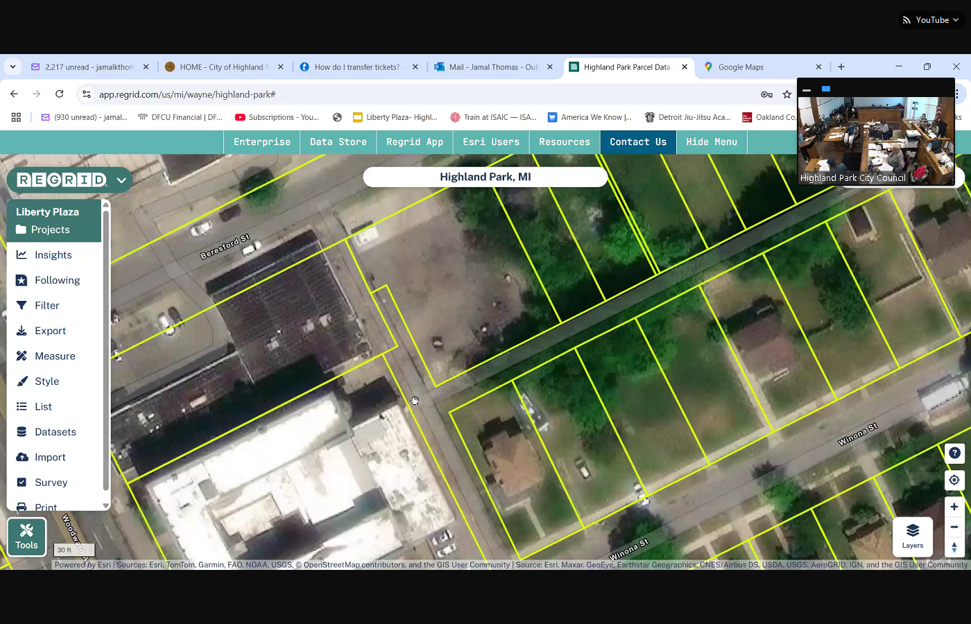
 Donovan Smith, principal planner with McKinnon associates and the planning manager for Highland parks Planning Department. Thank you. Thank you. So you do have before your resolution regarding the applicant DMC group and the Highland room located at 13232, Woodward. So the vacation they're requesting is of the alley, if you could highlight it, does a dog leg. Currently, half that alley is is vacated today. What they the applicant is requesting to vacate the remaining portion of the alley. So it's just that area just north of your cursor. So if you go up yep, from that corner Continuing north to that corner, yep. So that space in between is about 10 feet wide, maybe about 40 feet long. It used to be a former alley. As you can see, half of it is already vacated. That was likely vacated when that property went through its site planning process to put the initial parking lot at that parcel they are requesting to vacate the rest of that alley so then they could consolidate it with the rest of their property, and then they can close off that back portion of that alley with the fence to stop individuals from traversing into that parking lot and to provide more security for the visitors that park there. Okay,
+2
Donovan Smith, principal planner with McKinnon associates and the planning manager for Highland parks Planning Department. Thank you. Thank you. So you do have before your resolution regarding the applicant DMC group and the Highland room located at 13232, Woodward. So the vacation they're requesting is of the alley, if you could highlight it, does a dog leg. Currently, half that alley is is vacated today. What they the applicant is requesting to vacate the remaining portion of the alley. So it's just that area just north of your cursor. So if you go up yep, from that corner Continuing north to that corner, yep. So that space in between is about 10 feet wide, maybe about 40 feet long. It used to be a former alley. As you can see, half of it is already vacated. That was likely vacated when that property went through its site planning process to put the initial parking lot at that parcel they are requesting to vacate the rest of that alley so then they could consolidate it with the rest of their property, and then they can close off that back portion of that alley with the fence to stop individuals from traversing into that parking lot and to provide more security for the visitors that park there. Okay, Unknown Speaker
so just for the sake of
Speaker 1
I have to do it all the time, let me make sure I heard what you're saying. Yes. So as I look at this image here, as I highlight this image, I'll pull it up even closer. A portion of this alley has already been vacated. For those not familiar with re grid, if I put my cursor over a particular block, it shows what is the perspective boundaries of that property. As I move from the owner's property into his adjacent property, you'll see that that next block lights up blue as well. The section that we're referring to is this gap that's in here, correct with that doesn't light up at all and it is adjacent to his both of his pieces of property. In fact, it's sandwiched in between his two pieces of property, yes, and that this is in the right of way, owned by the city of Highland Park. So we will be vacating or releasing this small driveway size piece of land and vacating that alley so that it could be added to the parcels that are listed that is correct. Okay, city council, you have questions on this? Yes, ma'am,
Unknown Speaker
what do you say? The
Speaker 15
reason for to they want to the African has indicated they get a lot of traffic that comes from the alley, the pedestrian traffic, so they walk through the alley and they can get into the parking lot. Yeah, and yes, and it's a public alley, yes, yes. So they want to close that piece off so they won't have traffic.
Speaker 7
Because for years, the Ohana garden folks was trying to
Unknown Speaker
get it allocated. Okay?
Unknown Speaker
And I'm going to let everybody know that I'm not.
Speaker 4
So I have a question. Yes, they excuse me going through the alley. Will the garbage or how garbage can be picked up for why?
Speaker 15
So that portion of alley would stay open to the public. So currently they don't, I don't believe they drive through and the applicant can clarify if they continue through the alley. I don't think they do, because that would be the applicants property that they would drive through. So the way, the sorry, the way trash would access the alley today would continue as it's currently used, as it's currently Yes, nothing would
Speaker 4
change. Nothing's going to change other than the fact that they're just going to own that little
Speaker 15
piece. Yes, and the city won't be responsible for that piece of land,
Speaker 4
okay, but we can still go through it, and the trash will be still able to be picked up. Yeah, as normal, yes, you just would not, because they already own that first part from bisper to where he pointed
Speaker 15
at  correct. So this entrance here, you would not be able to make a right and go straight because they plan on closing that off. But coming from the other side, I apologize, I don't know that street name, but coming from the other street Winona. Yes, they'll be able to make that left, and then they wanted to make a right down the alley. They could that would remain open.
+1
correct. So this entrance here, you would not be able to make a right and go straight because they plan on closing that off. But coming from the other side, I apologize, I don't know that street name, but coming from the other street Winona. Yes, they'll be able to make that left, and then they wanted to make a right down the alley. They could that would remain open. Unknown Speaker
And this is the piece of land that we're talking about
Speaker 4
here. Yes, I guess I got lost. No, I want to know if they could come all the way through the the priority of whoever our dumpster company will be, they'll be able to come from Winona all the way through bisper. No. How do they come? Now
Speaker 15
they shouldn't be able to go through bids for now, because that's all pup that's private that. I'm sorry the alley adjacent to Beresford is currently private.
Speaker 4
I get that. So I'm asking, though, how does the garbage get picked up? Right now,
Unknown Speaker
I'm I'm not exactly parking lots.
Unknown Speaker
I got a question.
Speaker 11
So, okay, so my first question, I know they're, they're open at night. Are they ever open during
Speaker 15
the day? The Highlander, that would be, I would assume so. But they would have to answer that question
Speaker 1
they are pitching. They're very robust. They're very robust the pictures
Unknown Speaker
during the day, because
Speaker 11
it's very congested on beards. I mean, when that parking lot gets full, yeah, straight across the gas station.
Speaker 1
So, 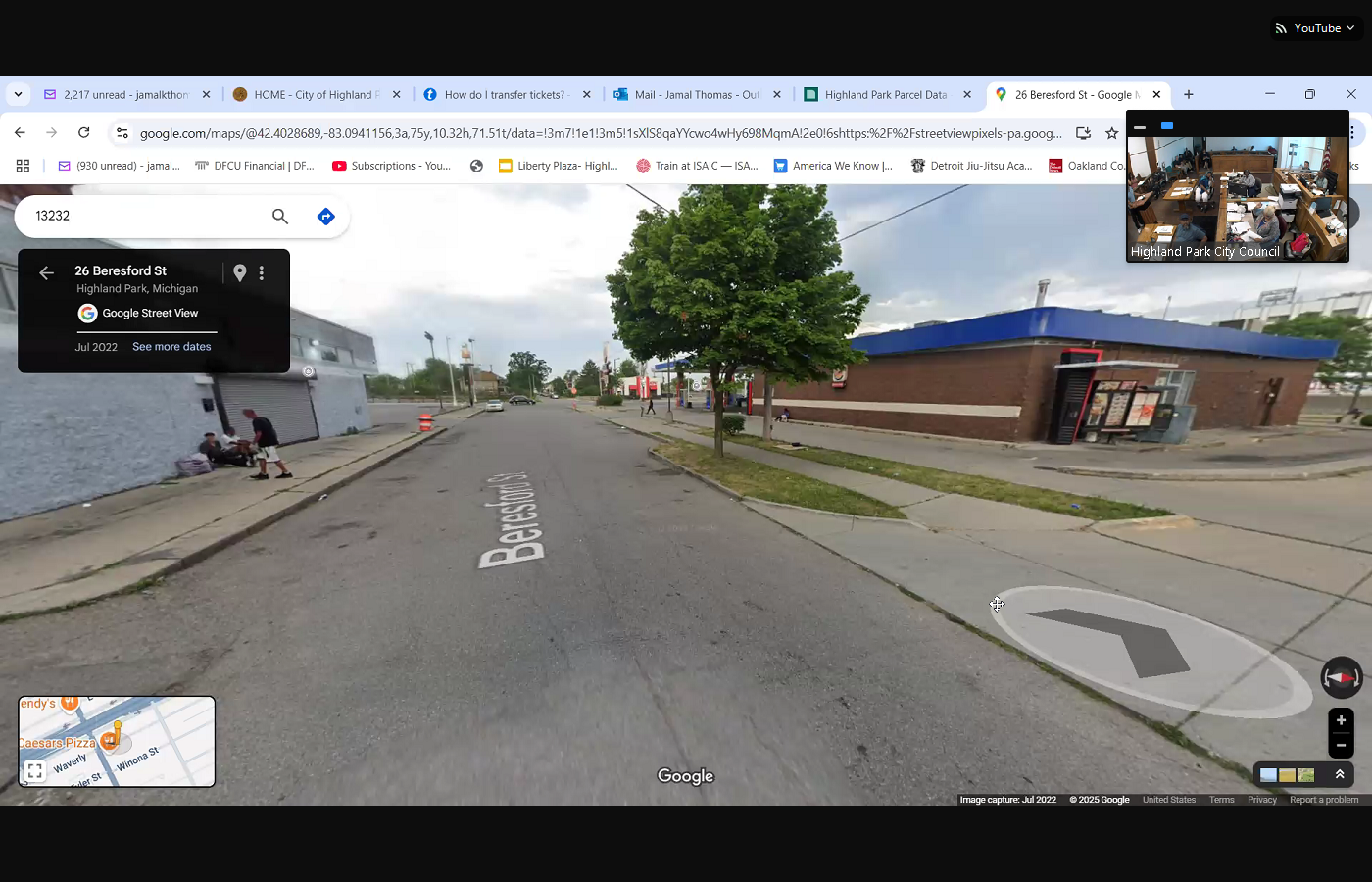
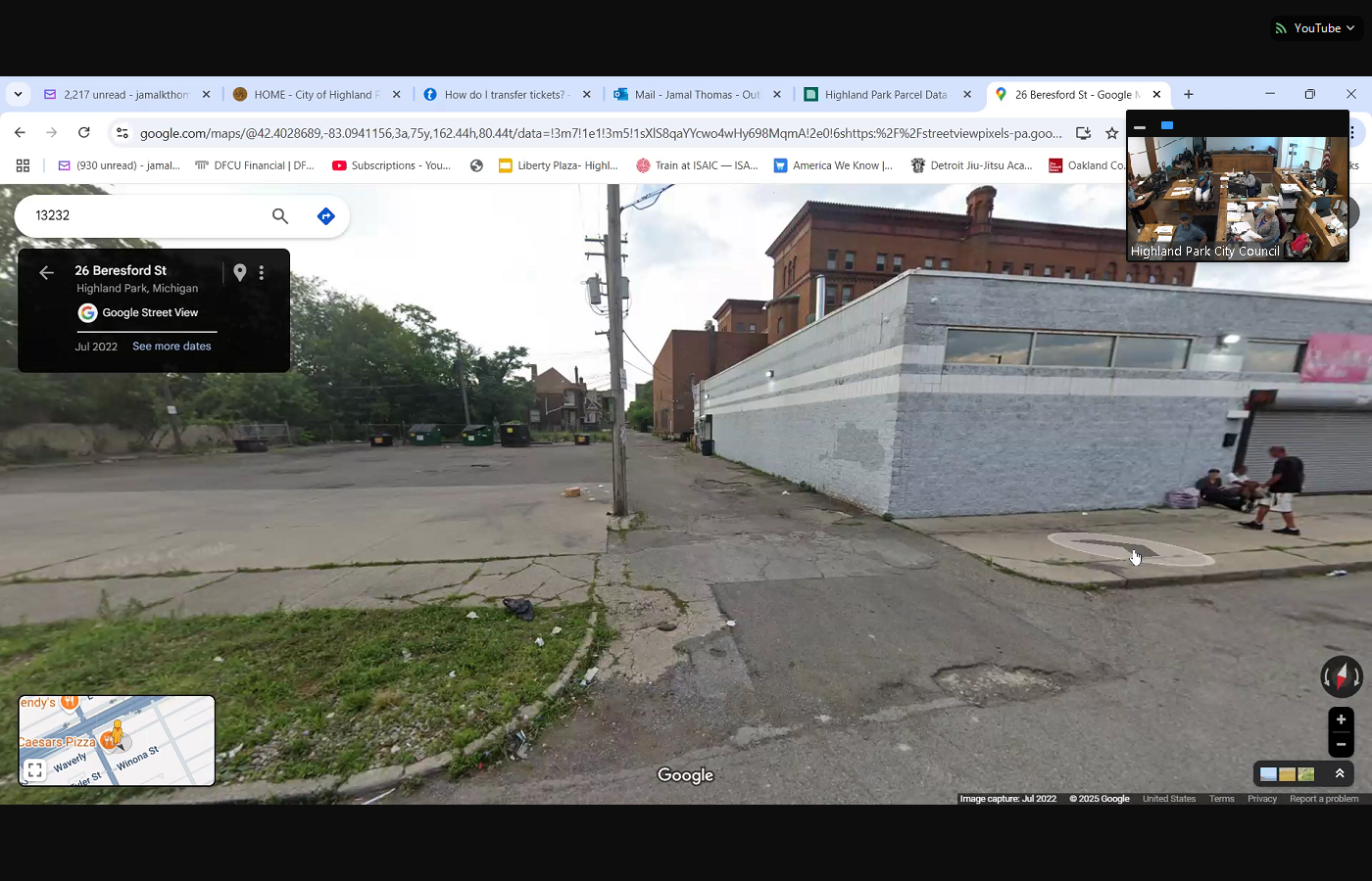 hold on a second. So these pictures are a great illustration of the reason why those improvements that have been made have been so significant. I can imagine for the for the residents that are in this area, what we see here is derelict vehicles, people working in their cars. If I go up and down the street, we see people, I mean, it's almost as if you couldn't ask for a more nutrient rich environment. In the Google map, you have people that are lawyering on the property as it is right now. And this will be very informative to me. If in the past, I had attempted to make a take a similar action and I was unsuccessful, this will be very informative for me. This should be a great opportunity for me to plug into what I'm hearing so that as to miss Robinson's point. We said no in the past to something like this. And so considering, if we go back here to land grid, we're talking about a piece of land that is adjacent to now, priority can get all the way down here, and they can get all the way in the back of this property, a priority typically picks up the trash from the front. Highland Park is unique in that way. But what we're talking about is a strip of land that they don't own, that doesn't light up, that they want to close their property off it and so in my opinion, it's been illustrated exceptionally well. Madam Protem, I see your hand has been up. I don't want you to continue to wait. Go ahead, ma'am, 12345,
+3
hold on a second. So these pictures are a great illustration of the reason why those improvements that have been made have been so significant. I can imagine for the for the residents that are in this area, what we see here is derelict vehicles, people working in their cars. If I go up and down the street, we see people, I mean, it's almost as if you couldn't ask for a more nutrient rich environment. In the Google map, you have people that are lawyering on the property as it is right now. And this will be very informative to me. If in the past, I had attempted to make a take a similar action and I was unsuccessful, this will be very informative for me. This should be a great opportunity for me to plug into what I'm hearing so that as to miss Robinson's point. We said no in the past to something like this. And so considering, if we go back here to land grid, we're talking about a piece of land that is adjacent to now, priority can get all the way down here, and they can get all the way in the back of this property, a priority typically picks up the trash from the front. Highland Park is unique in that way. But what we're talking about is a strip of land that they don't own, that doesn't light up, that they want to close their property off it and so in my opinion, it's been illustrated exceptionally well. Madam Protem, I see your hand has been up. I don't want you to continue to wait. Go ahead, ma'am, 12345, 
Unknown Speaker
the fifth, whereas I'll look at
Unknown Speaker
it if you want to, okay, I'll read, okay.
Speaker 7
The purpose vacation will be consistent with the adjacent Tod zoning and is required to support the applicants
Unknown Speaker
development goals. Can you explain that
Speaker 15
the rezoning is the second part resolution that's included in your packet when you vacate parcels currently on your zoning map, that alley does not have a zoning designation, so once we vacate it and be becomes a private parcel, we have to assign a zoning classification to it. That is the Tod District, which is also the adjacent district around those parcels, the Tod district, the transit oriented development district, is the mixed use district along the Woodward corridor, and it is the current district for the Highland room for that parcel. So what we're asking is to rezone the vacated portion that currently does not have a zoning classification, and to assign it the zoning classification that is adjacent to so I see him pulling the map up.
Speaker 1
This is the zoning map for those people who are in the audience who are wondering,
Speaker 15
yep. And if you zoom in to right where your mouse is, yep, right there.
Speaker 1
So  the Master Plan was the last master plan was submitted in 2018 I think I have that master plan. And the proposed for 22 1819, this is a 2010 map. And so the transit oriented development designation has been around for a very long time, and everything off forward avenue that was related to high speed rail or monorail, or whatever the train was that was proposed as part of the Detroit 2020 plan was the impetus for adding Tod. This is planning commission back in 2014 or 15 when I would sit on the planning commission. So these are not none of these things are changes. This is the existing zoning map. Everybody can access this zoning ordinance and the zoning map on the city's website. But if you look up and down Woodward Avenue, all of the purple that you see on the screen, as well as the area where the apartments are Manchester, place that is all oriented, that is transit oriented development with our town. So the nation goes all the way through the city of Highland Park. In fact, Detroit, future cities did a whole subsection on Highland Park for this follow through. So this has been around for almost 20 years. This has been a part of baked in the cake. Madam pro tem, I'll see you out already.
+1
the Master Plan was the last master plan was submitted in 2018 I think I have that master plan. And the proposed for 22 1819, this is a 2010 map. And so the transit oriented development designation has been around for a very long time, and everything off forward avenue that was related to high speed rail or monorail, or whatever the train was that was proposed as part of the Detroit 2020 plan was the impetus for adding Tod. This is planning commission back in 2014 or 15 when I would sit on the planning commission. So these are not none of these things are changes. This is the existing zoning map. Everybody can access this zoning ordinance and the zoning map on the city's website. But if you look up and down Woodward Avenue, all of the purple that you see on the screen, as well as the area where the apartments are Manchester, place that is all oriented, that is transit oriented development with our town. So the nation goes all the way through the city of Highland Park. In fact, Detroit, future cities did a whole subsection on Highland Park for this follow through. So this has been around for almost 20 years. This has been a part of baked in the cake. Madam pro tem, I'll see you out already. Unknown Speaker
Why are you trying to rezone
Speaker 1
it? No, ma'am, When? When? When, when it's done. Okay? I mean, I mean, I used to be the chairman of the zoning board, so I think I can answer that question. Go ahead,
Speaker 15
through  the Chair, if you could just zoom into that alley. Sure, just easier to show the diagram. The reason why we are rezoning to Tod for this particular piece of land. So that alley just above the W and Winona, it's, it's that white space, the zoning district, that purple district to the left doesn't carry over to the alley that we are vacating. So we're taking a piece of land that doesn't have a zoning classification, and then we're assigning that adjacent district, so it will be consistent.
+1
the Chair, if you could just zoom into that alley. Sure, just easier to show the diagram. The reason why we are rezoning to Tod for this particular piece of land. So that alley just above the W and Winona, it's, it's that white space, the zoning district, that purple district to the left doesn't carry over to the alley that we are vacating. So we're taking a piece of land that doesn't have a zoning classification, and then we're assigning that adjacent district, so it will be consistent. Unknown Speaker
Miss Martin, you had a question,
Unknown Speaker
yeah.
Unknown Speaker
How are they closing? How are they going to close off the the Allen
Speaker 11
fence? So they're going to move the fence that's already installed, either
Speaker 15
move or construct. I'm just not exactly sure what's what's there today, but they'll pull an application for a fence, and then, because they will own that land, they can install a fence between or along that rear property line. So
Unknown Speaker
it's going to be, the fence is going to be along
Unknown Speaker
the Highland, the
Unknown Speaker
back of the property towards the building,
Speaker 15
so just along the current alley, okay, parallel to beers for
Speaker 1
think this might help illustrate it, yeah.
Speaker 15
So  from the corner, I believe, the corner of that building to probably keep turning to the right, right, right, right, yeah. So somewhere in that area, and this is a different application, so I apologize I don't have the exact location, but it'd be from the back of that building to the right of the screen. So along that rear property line, that will be the extent of their property and where they can apply for a fence.
+1
from the corner, I believe, the corner of that building to probably keep turning to the right, right, right, right, yeah. So somewhere in that area, and this is a different application, so I apologize I don't have the exact location, but it'd be from the back of that building to the right of the screen. So along that rear property line, that will be the extent of their property and where they can apply for a fence. Speaker 4
Okay, Miss Monica, so just so that we're all clear when you say that building, that building being the Highland building, correct? So the parking lot, though, the fence goes, it's, it's way down here by that poll, am I correct?
Speaker 15
And and again, I apologize, that's a different application, and I don't have that application is all pending if the vacation goes to so I just don't have the exact location of where that fencing would be. No,
Speaker 4
no, 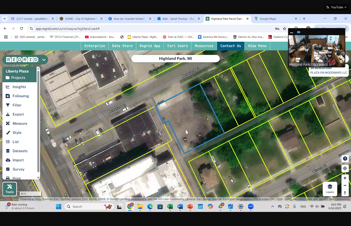
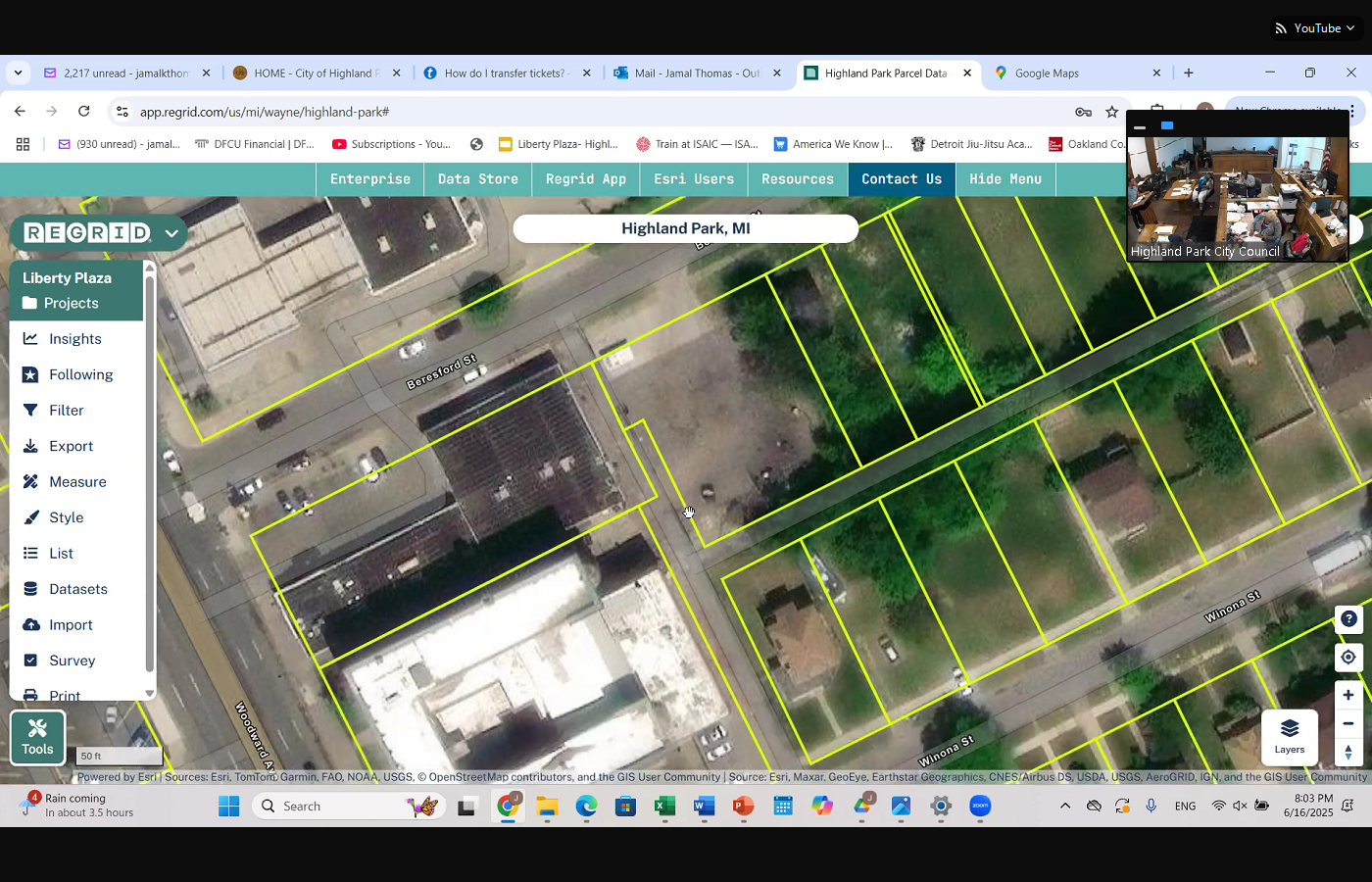 no, I'm not talking where they Well, I am talking about where they're going to put the fence. So go back to that the other screen where we're showing the little space, yeah, it's so so right? Is that right? So here it shows differently, right? But you see, that's their fence, though. Back. Go down south. Go south. To the end of the blue square. Go south. Come come back toward Woodward all along there. See where that fence is. Yeah, that's right behind the Y. They're not going to be able to, I know we're not wearing but so it has. So he's just going to add a fence. Go to the corner, mister. Yeah. Thomas, up here, right? Yep, nope. The other square, nope. You go, vacate right there, yes. So that's it. Goes straight across to expense. That's where he's going. If it gets approved, he would put a fence right there, just across the gap, just across the basically here, I don't know how I know mister Donovan asked about maybe, yep, there you go. Thank you.
+3
no, I'm not talking where they Well, I am talking about where they're going to put the fence. So go back to that the other screen where we're showing the little space, yeah, it's so so right? Is that right? So here it shows differently, right? But you see, that's their fence, though. Back. Go down south. Go south. To the end of the blue square. Go south. Come come back toward Woodward all along there. See where that fence is. Yeah, that's right behind the Y. They're not going to be able to, I know we're not wearing but so it has. So he's just going to add a fence. Go to the corner, mister. Yeah. Thomas, up here, right? Yep, nope. The other square, nope. You go, vacate right there, yes. So that's it. Goes straight across to expense. That's where he's going. If it gets approved, he would put a fence right there, just across the gap, just across the basically here, I don't know how I know mister Donovan asked about maybe, yep, there you go. Thank you. 
Unknown Speaker
Yep, see extra
Unknown Speaker
for doing tech
Unknown Speaker
I'm doing today. This
Speaker 4
is what he's going to he's asked to vacate because they already own the other piece. Now, here's my question, and I just want us to be very, very diligent and clear that he owns that other part, that we do not own, the alley on that end,
Speaker 15
the prop, the area of the alley that is within his property line. Uh, Council, Council President, if you could just highlight the big the Highland room parcel,
Speaker 1
someone here. No, the whole Highland No, the whole Highland owned parcel, okay, excuse me. Let me just get this annotation on,
Unknown Speaker
yep, yep.
Speaker 15
So all of the alley that is currently within that parcel outline he currently owns does currently on, yes, that is within his property limits, yes,
Unknown Speaker
okay, yeah, okay. So with that whole, that whole
Unknown Speaker
little seasons, yep, now place, the
Unknown Speaker
small place, yeah, he owns that whole thing.
Speaker 15
Yeah, that's all one parcel in one building, but the alley is the portion. So do you have the plan before you
Unknown Speaker
to change that space? That space is so many
Unknown Speaker
so right now we just want, no, we don't give him
Unknown Speaker
that little piece. I'm just wondering
Speaker 4
if inside so he already owns the other part. He just wants to get that little think it's 10 feet by 40 feet. Am I correct somewhere in there? So, but it's on there. So that's where we at right now. Miss Martin, then we gonna go to he has something else on the table. Yeah, they own the whole kind of, I mean, the whole meeting is
Unknown Speaker
called, yeah.
Speaker 1
Okay. So we are on item nine, a resolution to approve the vacation of a portion of the public alley adjacent to 13232, Woolworth avenue for DMC property management. Motion was made by Councilman O'Shea, supported by Councilman Manica. Would you take the role on Item nine.
Speaker 2
Nine a councilman, Shafi, Council President,
Unknown Speaker
I got a question before we vote on this. Excuse
Speaker 15
me. Did this go through zoning? Yes, this did go through planning commission. We had a public hearing week regarding the rezoning and the vacation on April
Unknown Speaker
9, I believe it's the second Wednesday.
Speaker 15
We had 123, I believe four public hearings that day, three of them related to this item.
Speaker 1
Okay, Madam Deputy Clerk, would you call the roll please?
Unknown Speaker
Councilman the Shafi
Speaker 2
Yes. Councilwoman Martin No. Councilwoman Manica Yes. Council Tim Robinson No.
Unknown Speaker
Council President Thomas
Speaker 1
Yes. Motion carries moving on under Community Development item 9b the resolution to approve the rezoning of the vacated parcel adjacent to 13232, Woodward Avenue to transit oriented development City Council. What is your pleasure?
Unknown Speaker
Okay, so which property is this?
Unknown Speaker
It's the same thing. This
Speaker 15
is the same vacated area. So right now it's just Yes, that same right now I thought we just approved it. So we the previous motion was to vacate the alley, which is to turn it from a right of way parcel to a private parcel. Now that that parcel has been vacated, we have to assign it a zoning classification. That is what this motion is for.
Speaker 1
And before Mr. Shafi, well, based on the zoning board, every square inch of the city has a zoning if it's municipally owned, it's municipally owned, but every square inch of the city has owned. Every single square inch of the entire city is zoned for something
Speaker 4
so still waiting on a motion, right? Still waiting on a motion I move to approve the rezoning of the vacated parcel that we just
Unknown Speaker
approved.
Unknown Speaker
Chair offers a second
Speaker 4
just to explain, Mr. Smith, briefly explain the rezoning please,
Speaker 15
yes. So the rezoning process is a two step process. It starts with the planning commission, where we hold a public hearing. The Planning Commission then provides a recommendation to city council regarding their opinion regarding that rezoning the planning commission on the April 9, second Wednesday from getting that date right in April, they did vote to recommend to city council to recommend approval for that rezoning, assigning the Tod district to that vacating
Speaker 4
so that that rezoning is now what or would be if it's approved, what would it be
Speaker 15
rezoned to? It will be rezoned to the Tod district the transit oriented development district, consistent with the adjacent parcel,
Speaker 1
yep. Okay, parcel right next door. Am I approaching? I see your hand? Um, smack. I'm sorry we finished.
Speaker 4
Um, yes, I just know that that that's a little bit a lot there, because even though it's because TOD is this, I don't want to say the city, but it's all over in the city, yes, in the LLC just happens to be in that particular area, correct? I'm sorry, it happens to be in that Tod area,
Speaker 15
yes, or adjacent to, adjacent to Yeah, cuz it's currently not in an area. So yes, yes, okay,
Unknown Speaker
I'm done. Okay, madam pro tem,
Unknown Speaker
your fourth whereas,
Unknown Speaker
how does this align?
Speaker 15
It is consistent with aligning the district with the adjacent districts. So because the adjacent district is a Tod district, it would be in alignment to assign this district also to Tod, so it will be consistent. It won't receive a development use because it's just that portion of alley that will also be used for parking. So it doesn't have a lot of development potential, but it will be consistent with the surrounding zoning districts.
Speaker 7
So if they approve this resolution, it will become part of the bigger part. So it's already
Unknown Speaker
Yes, it will be a part of the larger development. Yes,
Speaker 1
okay, we'll take a roll call vote on item 9b That's a resolution to approve the rezoning of the vacant, vacated parcels adjacent to 132,
Speaker 4
I'm sorry. I know don't get me. Mister Thomas, I just, it's not a question. I just want to make a statement. So Miss Martin, I think you asked earlier about because that's a that's a weird kind of complex area. So if say, for instance, they did decide to redevelop that and make it something different, it would be difficult right there, because that one little piece would be offset that that is correct, you get what I'm saying.
Unknown Speaker
So and if I could,
Unknown Speaker
okay, yeah, please, thank you.
Speaker 15
Alternative scenario that property becomes is demolished, it's a blank site, and a new development is supposed to take place. If they want to extend or utilize that portion, they would not be able to, because it is a public right away, it is not a private piece of land. So in order to make the site cohesive and consistent, that's why they're requesting that vacation. So it'd be one full site without the kind of dog leg gap between the two parcels,
Speaker 11
right? And when I asked the question, when we were on the A, B, um, what is the future plan you were you said it's
Speaker 15
going to continue operating as the Highlander. Yeah, so there's not a new development proposed. This really just brings the site into they're only making changes on the inside. Yes, yes, no exterior changes.
Speaker 1
Thank you. Okay, so we'll take a roll call vote on item 9b resolution to approve the rezoning of the vacated parcel adjacent to 13232, Woodward Avenue to transfer oriented development. Would you go to take the role on that? Please?
Unknown Speaker
Councilman ashafi, no.
Unknown Speaker
Councilwoman Martin No.
Speaker 2
Councilwoman Manica, yes. Council Pro Tem Robinson, no. Council President Thomas, yes,
Speaker 1
and before we move on any further, so what we did is we just chopped the branch off that we were standing on. So we vacated the alley. Okay, now I'm talking to you now as a former planning commissioner and the chairman of the zoning board. What we did is we vacated the alley. Yes, okay. And then we took this piece of land that the Alley was vacated in, and we just made it disappear, and out of our zoning map, it has to be zoned something. It has to be zoned something. And what we just did for whatever reason. I don't, I don't exactly know what the reason is, but we just took that piece of land and popped it into oblivion. I'm going to pull this up, if I could clarify. Hold on just a second, that guy, yep, we're going to do that. We're going to do that. This map right here is the entire city of Highland Park. Every can't hear, please stop. Every square inch of this city is zoned for something. It has to have a label. So here we are with our expert planners, and they've taken us through the process to say that this section of property, this piece of property behind the building, is owned by the city. We don't want it. We're not going to maintain it. It's adjacent to this person's property. They want to take possession of it and fence it in and provide a secure environment, and in order for them to lawfully do so on their existing property, which is zoned transit oriented development, which is the entire area, everything from the alley to Woolworth, is owned transit oriented development in this area, just like when you get down to where the townhouses are, that's multi family, that's a RUV so it's it's zoned so that the area can be what it is. That's why we have all of those townhouses and apartment buildings, all of that adjacent to each other, has to be zoned that way. So what we just did, by voting no on that, is we vacated the alley, and then we just took this piece of land and just basically threw it over our shoulder. It's not zoned for anything now.
Speaker 3
So is this a little, I'm sorry, little arm push that we doing right here. Anyway, what can we move on to the rest of the agenda?
Speaker 1
Oh,  okay, okay. I just wanted to make sure that we so as we move forward, as we move forward with this, in order for, let's say, for example, there was another parcel on Woodward Avenue that wanted to, that wanted to have their alley vacated further north, this is the map. It's the same map. Yes, it's the same map. It's the same map. So whoever, if there's a person who had a piece of property and they wanted to get their alley vacated to take ownership of it, a good steward, somebody who's already been taking care of the land, yeah, like ohana, for example, they would it would have to get zoning. It would have to be zoned something. So
+1
okay, okay. I just wanted to make sure that we so as we move forward, as we move forward with this, in order for, let's say, for example, there was another parcel on Woodward Avenue that wanted to, that wanted to have their alley vacated further north, this is the map. It's the same map. Yes, it's the same map. It's the same map. So whoever, if there's a person who had a piece of property and they wanted to get their alley vacated to take ownership of it, a good steward, somebody who's already been taking care of the land, yeah, like ohana, for example, they would it would have to get zoning. It would have to be zoned something. So Unknown Speaker
can we move on to the next item, to
Speaker 15
transit, land development, right? Ask the question again.
Speaker 11
It wasn't unzoned. It was rezoned. It was approved to be rezoned as the transient oriented development, correct?
Speaker 1
No, we just voted. No, I'm sorry. Would you take when you get there. Did you give me the vote back on item 7b?
Unknown Speaker
Oh, no, no, no, I'm talking to the clerk. Jump around.
Unknown Speaker
We need to move on to the next
Unknown Speaker
item. When you chair a meeting, I'll let you do the chair.
Speaker 2
Council member Shafi voted no. Councilwoman Martin voted no Councilwoman Rob Council Pro Tem Robinson voted no. So the
Speaker 11
rezoning, calling it the transit, brands and development,
Unknown Speaker
move on to the next state
Speaker 1
or something else. Yes, could you tell her what it's
Unknown Speaker
No? Could you tell what it's on for now, the the
Speaker 15
area that we vacated was a private, public right away. It was a right away. It did not have a zoning classification, because it was a public right away. Once we vacated it, it became a unzoned parcel. It was not it did not have a designation. The rezoning as it is titled titled is to assign it a designation, which is the Tod district, and
Unknown Speaker
that's what the planning commission recommended that we do today
Speaker 11
to turn it into a transit develop, just to
Speaker 1
give 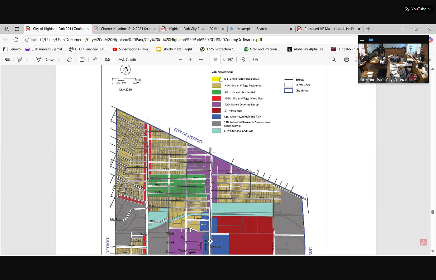
 it some kind of zoning. So if we look at the map, we have a choice. You see this tan area here. You see the yellow hair area here. So right behind was Winona. Let me zoom the map out that color coding shows us. Give me my color coding, please. I'm waiting for it to load. Okay, so that is single family residential. So that yellow represents single family residential. So the space between these two, we have single family residential over here to your right, and we have Tod over here to the left. If you look, the gas station has transit oriented development that extends into the middle of the block because it's a gas station. Something similar happens here on Woodward Avenue, where you have Glendale, Avalon village, that's all transit oriented development extends all the way down to the block. In fact, on several blocks on Buena Vista, where Barber is, transit oriented development goes all the way to John R. And this map was done for us by professionals planners who made a decision based on the data that the zoning should go so transit oriented development goes all the way to the corner
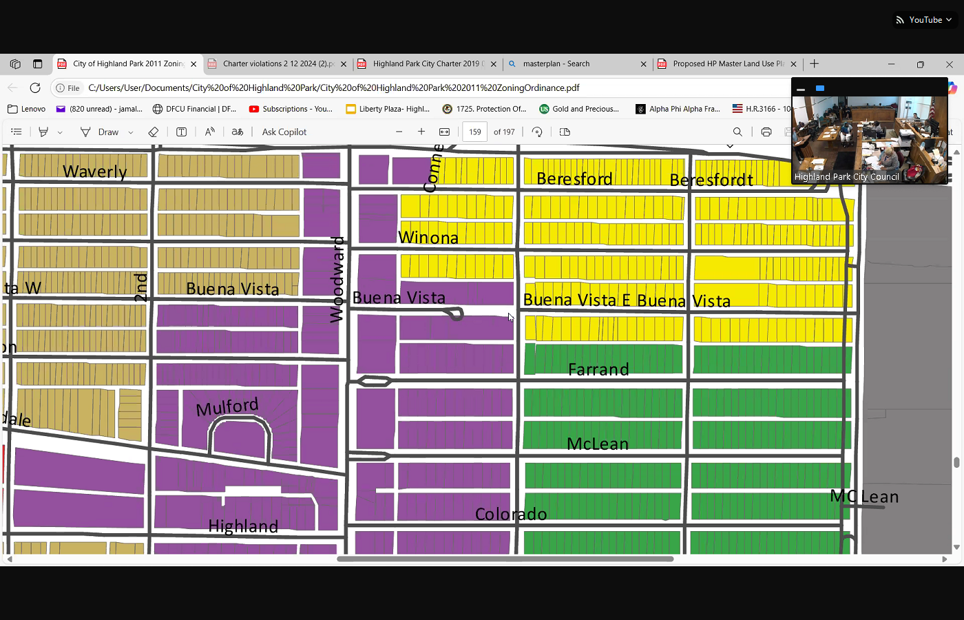
 of John R and Massachusetts, John R and Rhode Island. John R, Colorado, John R, McLean, iron, Ferran, John R and Buena Vista border by the alley. It stops on Winona. And bears for you see what I'm saying. That purple, this transit oriented development goes all the way to John R. And this was the project that was put forth to create. What does that bring? Or our master plan? This comes from my master plan. I'm sorry that's a cul de sac at the school. That's a cul de sac at the school. So now it doesn't have any zoning at all. And I wanted to make sure that that was clear. My purpose of doing this was to make sure that we was to make sure that we thoroughly explain what we just did because we didn't. So it's either, either we're going to zone a residential, we do want to zone a yellow and make it residential, or we're going to zone A Tod. It's 10 feet off of the building.
+2
it some kind of zoning. So if we look at the map, we have a choice. You see this tan area here. You see the yellow hair area here. So right behind was Winona. Let me zoom the map out that color coding shows us. Give me my color coding, please. I'm waiting for it to load. Okay, so that is single family residential. So that yellow represents single family residential. So the space between these two, we have single family residential over here to your right, and we have Tod over here to the left. If you look, the gas station has transit oriented development that extends into the middle of the block because it's a gas station. Something similar happens here on Woodward Avenue, where you have Glendale, Avalon village, that's all transit oriented development extends all the way down to the block. In fact, on several blocks on Buena Vista, where Barber is, transit oriented development goes all the way to John R. And this map was done for us by professionals planners who made a decision based on the data that the zoning should go so transit oriented development goes all the way to the corner +2
of John R and Massachusetts, John R and Rhode Island. John R, Colorado, John R, McLean, iron, Ferran, John R and Buena Vista border by the alley. It stops on Winona. And bears for you see what I'm saying. That purple, this transit oriented development goes all the way to John R. And this was the project that was put forth to create. What does that bring? Or our master plan? This comes from my master plan. I'm sorry that's a cul de sac at the school. That's a cul de sac at the school. So now it doesn't have any zoning at all. And I wanted to make sure that that was clear. My purpose of doing this was to make sure that we was to make sure that we thoroughly explain what we just did because we didn't. So it's either, either we're going to zone a residential, we do want to zone a yellow and make it residential, or we're going to zone A Tod. It's 10 feet off of the building. Unknown Speaker
Okay, Miss, Miss
Unknown Speaker
Manica. We're in between.
Unknown Speaker
We're in between
Speaker 4
items here, but go right ahead. Okay, yes, and so we can get to the next item. And I guess we this is going to have to something's going to have to come back here, but it even though we talking about that little parcel, actually it's further down. Also, as far as the rezoning, am I correct, we still have to rezone the parking
Speaker 1
lot. No, that's a whole another ball game. Okay, gotta come back to us and get that
Unknown Speaker
so they they're going to come back for that piece. Oh,
Unknown Speaker
am I right? They will not.
Speaker 4
So it says zoning designation for a subject I heard you, Miss Martin, I'm trying to answer your question and get my question answered as well. The the current zoning designation for the subject area includes r1 single family residential and unzone right away. Mm, hmm,
Speaker 15
correct. Those are the adjacent designations, the Tod, the r1 designation and the unzone portion, yes, so all of the residential that will be to the east is all zoned single family. So and that would remain,
Speaker 4
I think that there's some some other questions there, which is, President just said it's another ball game because that was residential. So that has to also be rezoned. It does not. It does not no only the portion that we are vacating
Unknown Speaker
needs to be resolved. Well,
Speaker 4
I know that, because we just vacated correct, but in the meantime, now it's something has to come back.
Speaker 11
You said that the planning they suggested
Speaker 15
Tod the Planning Commission, we provided a technical analysis, and gate presented that to the planning commission. Based on our analysis and discussions, they agreed with staff's recommendation to rezone to Tod. Is
Unknown Speaker
that in here it should be yes.
Speaker 4
Okay, so I'm sorry, going forward, can we make sure, yeah, that we have a property. So I think the in question part for some of us is, do they really the ownership, and did we do a survey? And do we have all that information?
Speaker 15
All the information was, it's in the Yes. And MCA looked at it. They provided us an approval that the vacation did not conflict with any plans or anything they had going on.
Speaker 1
Okay? Thank you. Okay, moving on to item 10 under engineering resolution to issue a request for quote. Thank you, sir. I don't I didn't mean to be a Brook. I'm sorry like that. But moving on to item 10 under engineering resolution to issue a request for quote, for Cinco catch basin repair city council, what's your pleasure on this item? This item,
Speaker 4
I move to approve resolution to issue requests for quotes for sinkhole and catch basin repairs. Support
Unknown Speaker
motion made to
Speaker 1
approve the resolution for quotes made by Councilwoman Manica supported by Councilwoman Martin, questions, concerns, dissent, Roll call, please. Would you?
Unknown Speaker
Councilman a shopee, yes?
Speaker 2
Councilwoman Martin, yes, Councilwoman Manica Yes, council Pro Tem Robinson Yes, Council President Thomas,
Speaker 1
Yes. Motion carries moving on to Item nine of the Public Works. It's a resolution to approve the contract with Priority waste LLC for solid waste collection services City Council. What is your pleasure on this item?
Unknown Speaker
Sorry, I missed that one
Unknown Speaker
resolution. This is the resolution to approve for public
Speaker 4
works, yep, okay, resolution to approve contract with Priority waste LLC for solid waste collection service that a motion to approve, a
Speaker 1
motion to approve. Okay, so, motion on the floor from Councilwoman Manica, supported by the chair, questions concerned or dissent City Council. I'm sorry. Questions, madam, madam, madam, Deputy Clerk, would you please call the roll on item nine? I got questions. I'm sorry. Let's take a pause here. I'm sorry. This is, no, this is our country. This is, uh, you're right. This is the renewal. Mr. Sharpie, go ahead.
Speaker 3
Um, I'm not really seeing a pricing in this contract.
Unknown Speaker
Seeing $230 an hour,
Unknown Speaker
not seeing the prices in this contract.
Unknown Speaker
So last page, $52,875.48
Unknown Speaker
Yes, you hear me, right.
Unknown Speaker
So the pricing is on the last page, so
Unknown Speaker
is that what that's costing us a year?
Unknown Speaker
And the bid sheet is on page 17,
Unknown Speaker
one, year two, year three,
Unknown Speaker
year four, year five, years different price of each year. I
Unknown Speaker
Okay, okay, the first year,
Speaker 1
price increases by less than 5% for the second year.
Unknown Speaker
The third year price is
Speaker 1
a 6% increase from the first year. These are inflationary costs, sir. I'm doing the math right here. As I said, the third year is a the fourth, I'm sorry, the third year is a 7% increase. These are round numbers. This is so straightforward that is frightening. Um, these costs. We're talking year over year. Yeah, the prices are there. There's two pages of actual cross Go ahead. Miss pro tem,
Speaker 7
okay, I see each collection in this contract resolution is it doesn't explain how the leaves
Unknown Speaker
are to be packaged and picked up.
Unknown Speaker
Is it here? Prior here?
Speaker 3
Okay. And also, is there a way that we could compare this prices to what we are paying before? Cuz there's somebody new, right? Uh, to tell you when we would, yeah, yeah, yeah. GFL, okay, what were we paying them, as opposed to this contract here?
Speaker 1
Miss square, could you help me? Help me out the trucks that came through the neighborhood this week, they were priority, right?
Unknown Speaker
Yes, they were priority. No,
Speaker 1
yes. Here he comes, Mr. Burgess, could you add the trucks that picked up my trash the other day their priority? Right? Yes. Okay, so this is still a priority. This is a contract for priority, right? Priority. That's correct. Okay, just want to make sure that I wasn't the trucks that picked up my trash this week. Are the same ones on this piece of paper. Okay, good. Go ahead,
Speaker 3
mister. Okay, so hold, hold a second before you get started. Mister Burgess council president that Oh, okay. The the administration is giving leeway to have somebody go to work before they have an official contract that I've seen, that constantly happen in this city. Okay, so just because our already picked up our our garbage this week doesn't mean they were the garbage carriers for us for the entire year. It was GFL. And I'm curious as to what we were paying GFL and what we're paying them now, because we didn't see a contract for GFL, they were already here when council came in when, when this particular council came into play. So I'm simply asking the question, what will we pay in GFL compared to what we're paying now?
Speaker 1
Okay? And then mister Burgess as of January one this year, who was our trash service GFL at that time, as of January one, and they ended our service to win sometime
Speaker 9
in January, I came to the committee and asked that,
Unknown Speaker
yeah, so they were, so we went out
Speaker 9
to the And in answer to your question above, we say that the current rate, okay, okay, that's what we are paying
Speaker 1
now and then and then, is it? Am I? Am I correct in that priority purchased? GFL, that's correct. Okay. Thank you very much. Go right ahead, sir.
Unknown Speaker
And so you see the
Speaker 9
current rate there. So look here, and the yearly I'm sorry.
Speaker 3
It's fine. It's fine. Mr. Burton, I have a slight headache, you know, so please forgive me. Nobody's trying to say that you're wrong. Council President, we get that part. Okay? What I simply ask the question of, have the rates change from what we're paying GFL then to what we're paying priority. Now,
Speaker 1
my apology, Mr. Sharpie, let me, let me. Let me. Just a simple question. Accept my apology. Okay, accept my apology. Mr. Burgess, could you please provide Mr. Sharpie with some clarification?
Speaker 9
Priority purchased. GFL, wait, early January, February. I don't have the exact dates, okay? And in doing
Unknown Speaker
so, and in and in doing so, ma'am, I'm a chemist. I don't do
Speaker 9
and in doing so, they assume the contract
Unknown Speaker
okay, just like it was, just like it was okay.
Unknown Speaker
Thank you so much for clarifying that
Speaker 1
I get cranes. Miss, miss the newspaper. Thank you, Mr. Burgess, I appreciate that. Cranes. It's stuff like that. Okay, so any more questions? If not, we go ahead and take the role on this item. This is a resolution to approve the contract with Priority waste management made by council woman Manica, supported by the chair. If you would take the role on that, please,
Speaker 2
Councilman and Shafi Yes, Councilwoman Martin Yes, Councilwoman Manica Yes, council Pro Tem Robinson Yes, Council President
Speaker 1
Thomas Yes. Motion carries moving on to item 12 under police department, we have a resolution to approve the purchase of two new police vehicles from Gorno port for the police department. I will read this as a walk on whereas the city wishes to add two new patrol vehicles to replace the current aging fleet. Vehicles will assist in one, the reduction of maintenance expenses to improve vehicle uptime, and three, the reduction of crime. And whereas the city of Highland Park Police department requests a quote for two new 2025 vehicles to the state of Michigan Mido program to obtain optimal pricing. And whereas, going on Ford offered two new police vehicles for $93,770 and whereas the vehicles will require upfitting at a total cost not to exceed $20,000 and whereas the state of Michigan my Deal program is an extended purchase program which allows Michigan cities to use state contracts to buy goods and services. And whereas the city is currently a my deal dues paying member for Gordo and Gordo Ford is a my deal vendor. And whereas the price of the my deal contract for the vehicles from Gordo Ford has an overall savings of approximately $15,100 that could be realized by the city when compared to vehicles purchased from other vendors. And now therefore be it resolved that the city approves a purchase of two vehicles from going on four for a total cost of $93,770 and the up bidding not to exceed $20,000 and the upfitting term, I'm assuming, is related to what is necessary to transform a standard vehicle into a police vehicle. So that is the resolution for the public City Council. What is your pleasure on item 12, resolution to approve the purchase of two new police vehicles from going on forward for
Speaker 11
the police department. Do we already call a motion for it? Yep. Okay. And you said uplifting is just transforming.
Speaker 1
Upfitting, yes. Ma'am, I move to approve, sorry, upfitting of
Speaker 4
two new police vehicles from going on Ford, for the police department. Say it again. Ma'am, I moved to approve the purchase of two new police vehicles from going on Ford, for the police department,
Speaker 1
Chair offers a second. Questions. Concerns, yeah, I got questions. Go right ahead, sir. How many cars
Speaker 3
since? Since January, 2023
Unknown Speaker
that we bought the police department so far,
Speaker 5
I believe five. Were they all new? Yes.
Unknown Speaker
And how many cars do we have in our fleet altogether? Give me one second. I
Speaker 10
I believe we have 15 vehicles, which includes UC vehicles as well as transportation
Unknown Speaker
vehicles. Aren't they all the same year?
Speaker 3
No, that should be new, because we bought that the last year. So that should be new. The truck and and the basin that goes into the truck to catch the dogs, to hold the dogs were all bought last year. So I know during Well, that's gotta be new, because I remember it, it is new. Okay,
Speaker 11
so, so they're not all the same year. No,
Unknown Speaker
they vary from
Speaker 10
our oldest vehicle in the fleet being probably at 2008 the oldest
Speaker 3
vehicle it's 2000 and and and how many vehicles are outdated? I don't understand the question. I mean, how many of them are old? Like 2008
Unknown Speaker
2007 How many do we have like that? Uh,
Speaker 10
most our transportation vehicles are older. Most of our police vehicles are 20, like our patrol vehicles that are signed to patrol are 2020, and newer. Okay,
Speaker 11
I got another person, Mr. President, yes, ma'am. Did we consider other other than Gorn, porno, Ford? We consider any other places?
Speaker 10
Yeah, we considered other, my deal vendors, which were, obviously, there's other brands, Chevy and Chrysler. Unfortunately, the dealerships, the My dear dealerships, that stock, the other brands were not, did not have vehicles in stock because we, we actually preferred to get the Durango, because that's what the majority of our fleet is. But they don't have, they didn't have them in stock.
Speaker 1
Chief, this was, was this a part of our budget for this year? Was this budgeted?
Speaker 10
Yeah, we set money aside in capital outlay. Okay? And again, I apologize for bringing it so late, but I wanted to make sure that we did have the funding available at the end of the year, so we kind of waited till the last minute to confirm that we would have funding available to make this purchase.
Speaker 11
Okay, go right ahead. Miss Martin, okay. So chief question, you know, so we're, we're spending about about 45,000 per car, correct? So my question is, Is there anywhere else that money that could have been allocated to, like, I don't know, getting a recruiter to get more police officers out there? Well, sure, we
Speaker 10
got a million things that we need. We could build a jail, we could do all these other things. But the problem is, if our cars break down, we can't answer runs. We're doing it by foot. So, so we kind of prioritize these expenses. In previous years, we went years without purchasing vehicles, and that hurt us, because we had numerous vehicles in the shop. We were expending, we were spending a ton of money on repairs.
Unknown Speaker
And basically these vehicles are being ran,
Speaker 10
you know, around the clock. So it's it puts a lot of wear and tear on these vehicles. We average.
Unknown Speaker
Our cars are averaging right now, 98,536
Speaker 10
miles a year. Which works out to be 98,536 in our cars, which average works out to be about 30 something, 30 miles a
Speaker 5
day. Is that a year correct per vehicle,
Speaker 10
which in a 2.9 square mile city, that's significant amount
Unknown Speaker
of drives, a lot on a 2008
Speaker 10
No, no, no, the 2000 eights are transportation vehicles, yeah. So like prisoner transform, I have things like that.
Unknown Speaker
Okay. Further questions so chief,
Speaker 3
we have the majority of our fleet is 2020 and up Correct, correct. So that means that each one of our vehicles, the majority of our vehicles is less than five years old. What's the, what's the what's the lifespan of of a normal police car? Say we have bustling a city, you know, which we really don't it's only 8000 people here, but say we did have a bustling city, how long would a squad car last the city?
Speaker 10
Well, I mean, that's a difficult question, because when cars go down, so if we have so many vehicles, if a car goes down, let's say it's out at the dealership, like right now, we're looking at repairs that sometimes take excessive two months at the dealerships, because even for vehicles that are under warranty, because that's the nature of car repair these days. So that car is down, which means it leaves us a smaller pool of vehicles, which means those vehicles are being consistently ran. So, you know, consistently running vehicles over and over puts more additional wear and tear on it, which increases our maintenance costs. It's a question I really can't answer, as far as what's, what's the where, you know, what's the average lifespan of vehicle, because it's solely based on usage. Okay, so
Unknown Speaker
the last five cars that were purchased, yes,
Unknown Speaker
were all purchased
Unknown Speaker
last year. I
Unknown Speaker
think we had one in 2023
Speaker 3
but the other four were purchased last year. So we're averaging a new car in 90 days. So that's, that's an
Speaker 10
incorrect statement. We didn't purchase vehicles last year. We did two purchase vehicles. Last year we purchased in 2023 we purchased them under a grant. Those did not come out of a general
Unknown Speaker
fund, so all five, I'll
Speaker 3
go back and check my notes. Okay, so, so if we purchase in 23 that comes out to one new car every 90 days,
Unknown Speaker
okay, okay, with a little bit extra over
Unknown Speaker
I would challenge your math. I am
Unknown Speaker
what I'm concerned with you.
Speaker 3
It's fine if you challenge the math. I'm asking the question, okay? Because I already don't like the police department to begin with, so I'm really being nice. Thank you for making that statement. Really being nice. I appreciate that. Okay, I'm just concerned about the expense. I'm concerned about the expense. Alright,
Speaker 10
Mister Shafi, I'll be completely honest with you, I didn't expect a fair vote from you. Anyway. Good,
Unknown Speaker
good. I'm
Unknown Speaker
glad you feel that way. Okay,
Speaker 1
so we're going to move on to item 12 on the police department. The motion was made by Councilwoman Manica, supported by the chair, would you go ahead and take the roll on item 12, resolution to purchase two new police vehicles.
Speaker 2
Councilman ashafi, yes for the new vehicles. Councilwoman Martin Yes. Councilwoman Manica Yes. Council Pro Tem Robinson.
Unknown Speaker
Council President
Speaker 1
Thomas Yes. Motion carries, so I'm going to set my timer. Thank you so much, chief. Go ahead,
Speaker 4
just real quick, Chief, I know we probably don't have any that we just don't have no more. So say our vehicles that we can't use. Can we put them in auction?
Unknown Speaker
So we do. We auction our vehicles.
Unknown Speaker
You the council had approved
Speaker 10
us to use gov, GOV bids. So that's who we that's who we utilize when we auction vehicles that exit our fleet for whatever reason.
Speaker 4
So okay, thanks. Thank you so much, sir. I forgot. Thank you. Thank you
Speaker 10
Council. Thank you. Councilman ashafi, I appreciate it. Yeah, sure,
Speaker 1
yeah. Okay, now we are at the portion of we're at the end of all business for the city has concluded, and before we move into citizens participation, as I said at the last meeting, don't judge us up here. We're regular folk. Okay? So we have to go through and read this, these documents. This document had to be read by us all the it that you saw tonight. Somebody had to go learn how to do that before they could sit at this desk and make it look easy, because it's not you have two minutes and a couple over to make whatever statements that you would like to make today. I'm gonna start with my people online. If you don't mind if I still have hands online, I'm asking the people who are logged in online if
Unknown Speaker
you would like to go ahead and get your comments made
Unknown Speaker
going once
Speaker 1
people online. Tucker Jackson, note taker, Wooten Metro. Zayed Morgan, okay to the people in the gallery, please feel free to line up here to make your statements. I want to see how robust this line is before I get my time in together. Because I know I don't want, I don't like interrupting people when they're talking. I really don't, but I want to make sure we adhere to time. We are at almost nine o'clock. So if you would please kindly state your name, I won't start your time until you say your name, and then I will give you your time to go ahead and make your comment.
Unknown Speaker
Good evening, Highland
Speaker 16
practice. My name is Bonita Lavell. I reside in 92 Tennyson, and I'm coming because of a complaint. I have lived at that address since August of 2018 there is, there is a lot next to me. When I moved in, I went to the city and I told them I wanted to buy the property, they put stipulations on me. Said it had to be cleaned up, pictures had to be taken. I had to bring them to the court. Since that time, for the last five years, I have maintained that land as well as my property. Three weeks ago, there were some neighbors next door. They said that they came and they were allowed to buy the property without giving me a chance to purchase it. I am terribly upset. I sent a letter last week to the mayor and my district person. I didn't receive anything back. I came. I spoke with her today. I would like that resolved again. I've lived there longer, since 2018 the people next door on the other side were able to buy the lot, and I feel I was told that it would go to me, I would have first dibs. That was not the case. So I'm very upset about that. Ma'am, could you give me your name one more time? My name is Bonita Lavelle, L, E, A, V, E, L, L, and 92 Tennyson, Tennyson and John R. The Corner House is where I reside, and I hope it goes in my favor. If that's the case, then there's a dispute. I can come in and purchase the land tomorrow, when it opens, a court opens because I've wanted it, and again, I'm the man that's been maintaining that I've maintained it for five years, and they said there would be no question since I was there first, but it was so June the third, I came up and checked with the treasurer.
Unknown Speaker
Thank you. Thank you,
Speaker 1
ma'am. Before you miss Lavell, before you sit down, did you talk to the CD director? Did I talk to who have you talked to the CED director?
Unknown Speaker
That's mister Clyburn. Have you talked to CED? Uh, no, I called.
Speaker 16
I again. I was up here for two days. I didn't get a call until earlier this week. Yes, ma'am, when I called someone, I said, you have to take it to the city council. And so, you know, I wrote a letter. I did speak with Miss manifest, she did acknowledge that she got an Anderson a copy to the mayor, but and everything is explained really clearly. And
Unknown Speaker
I have a letter from the man that's maintained that, did you? Did you apply for? Did you? They told me. They said, Miss Lavell, there's no rush, because you went there first
Unknown Speaker
I see you can come in and you can
Speaker 16
purchase it, because the other house was vacant. So I said, that's fine. I'll just maintain until, you know,
Unknown Speaker
but I am prepared to buy the property today. Now,
Unknown Speaker
thank you. Okay, thank you, ma'am.
Speaker 1
Go ahead. Miss Pat I thought who was brief here, who was next?
Speaker 17
Danny. Pac Man, I live between second and third on Avalon, and there's a trash dumping problem. And I understand there's a city cleanup coming up, and if the city could provide a trailer to take a small pile of trash to one of the dumpsters, that would be really appreciated. I have these photographs.
Unknown Speaker
It is right by a giant pile of trash.
Speaker 17
Yeah, there's a city owned property, 161 Avalon, where the backyard has an enormous pile of trash, and it's been a dumping site for a long time. The new pile of trash near the old pile of trash. So that's kind of a bigger project, but all I'm trying to do right now is remove this small pile of trash that's right in the middle of the alley and blocking me from driving down it, as well as the people restoring the house right next to
Speaker 1
me. Thank you. Thank you like the time, man. Thank you. I made it you. That.
Unknown Speaker
Yes, sir, good evening,
Speaker 18
Mayor and her absence city council members and the citizens of this great city. Uh, point of information, I'm just curious on item, could you state your name? Sir. Robert Douglas laws Junior, thank you. Block club president east, grand and brush item, item number eight, I heard everything went on, but I didn't hear a price for the alley that was proposed to be given to the company the development. I heard no cost whatsoever. So I take it the city is giving them, potentially, that land, and also, when the resolution for that particular property, all the parking lots that take up beers for it, from the resolution that originally was proposed, this council voted yes based on a community garden. I don't see a community garden also based on access for everyone who uses their their businesses to alleviate, alleviate the public parking, the congestion, yeah, and it's not allowed. It's no trespassing sign right on that fence. So I don't know what's going on here, but the citizens are not being treated fairly, and so that gets that's the point of information. I want to stand here and really express my concern on June the second Council President, Thomas, you expressed your concern with the citizens not considering council members humanity. And you stated earlier, just a moment ago, we need that not judge this council. My issue is, and I'm addressing the entire council, I first of all want on behalf, sincerely give you my condolences. I'm serious about the hurt and pain that you are experiencing. It's quite evident, and you have every right to be in pain. I would, I could, I dare not imagine, to go through what you're going through. I shut her at the thought, my thing is understanding a loving Father, what you experience. I know that you're hurting. And in my profession, I realized that hurt people.
Unknown Speaker
Hurt people. Mr.
Speaker 1
Lyles, you are not about to take. No, you're not about to take. You're not about to talk about my personal
Unknown Speaker
because, Cindy, you
Speaker 1
this man off. Don't you come up here and invoke the name of my child? Don't you come up here and invoke the name of my child on some BS,
Unknown Speaker
I'm giving you my condolence. I don't I don't know.
Speaker 1
Okay, you come up in here and antagonize me like it's a joke. No, sir, you know what? Mister, no, sir, mister,
Unknown Speaker
condescending, patronizing, Mister Look,
Speaker 1
mister, don't I 2024, months I never saw you.
Unknown Speaker
24 months I never saw you. You
Speaker 1
since March, try Jesus. Don't try me. Okay, how you doing? Ma'am, go ahead.
Unknown Speaker
Go ahead. We
Speaker 19
come here first to say thank you. We come here first to say that the ancestors are great. We come here to say that they're they're loved. I come here today to just thank you for this moment. My concern is this, 29 years of being in the city, owning property, five years of denial and urgent plea for safety and equity, the back doors are in our alley. Five years ago, we stood before you, we pleaded we ask for protection. Today, businesses seek the same closure. This is about fundamental fairness. Since denial, we live in a war zone. Our back doors are open directly to Crime. It's a crime corridor. This is the only houses in the city of Highland Park that's set up where you walk out the back door, you're in the alley. People walk down the alley, break ins, harassment, cars being stolen, cars being sliced. Don't hear the pain that the residents here are saying to you, we have a new council. We have new ears. We thank you for your ears, but the residents are in pain. Business. Businesses are in pain too, but we've been here a long time. We just want you to sort of rehear the danger that we're experiencing then and now. No residents are investing for decades. Businesses church, they get their alley close. Businesses deserve protection. Residents do not. We are asking the request plead with fresh eyes. We earned our place here. We ask for council member to try to reconsider what we come. Come and see what we live police. We make police reports. I give you one example. Excuse me for my time. Recently, the man came in the we're right in the alley, broke it to the house, stole everything in the house. Okay? After he stole everything off, I witnessed my husband saw him. Chief Firebird saw him, went and did a citizen of arrest called Highland Park, the police department. We waited there for hour and a half for them to pick up this man with no fingers. He's broken into a lot of our houses. We said to the city, look, we got him here. We stayed there, fighting. They arrested him. This is the same man that took the stuff, take your stuff to put it on the street and sell it. But thank you. Please reconsider us. Thank you. Thank you. Ma'am, thank you. I'm Stubbs or Diane hoy, his name is Stubbs, no fingers. Thank
Speaker 20
you. Good evening, city council, good evening. My name is Keith. Hoy, that was my wife just spoke. We've properties owners on Church Street, the department complex there for 29 years, and before any of you were on the city council, I did with the guy came, he I did the same presentation with the community development and all the everything he did, we did, but we were denied. We were trying to close the alley. And one of my big points was the car the car dealer got the alley close. They closed at five o'clock and go home. The church got the alley close. They only come on Sunday. We did a 24/7 365, and we got to share with everybody else the thieves that come through the alley. Every time I see somebody come in an alley, I crunch up because, like, what you doing here? You know, we got stuff. We can't lay stuff around. You know, the back door opens into the alley. Here's a little diagram of back door. Come down the steps your car right there three feet so you it's into the alley. So every time I see somebody coming down the alley, you know, it's kind of crunchy. Thank God, when we did it before, when we tried to do it before, I found out that the East alley closes to Woodward was already on a old deed of ours, but the West Alley is the one we wanted to close, and we were we were denied. So today, with all new administration, y'all see differently. Y'all pass the guy before me. So I'm going to start the paperwork all over again, and I just feel like you going to do the same for us. Close the alley this time so we can fence it off and be safe at home, my grandkids, our my daughters, our family, our friends, we'll be safe living inside of a fence rather than being exposed to the alley.
Unknown Speaker
Thank you for that.
Unknown Speaker
You may be you may begin.
Speaker 21
Okay, thank you. I want to thank Mayor McDonald for yielding some time to solidarity to be able to speak on behalf of our solar streetlight project. Good evening. Council president pro tem, council members, neighbors and fellow community builders. My name is Shamika Nichols. I'm a resident located on Tyler street between Hamilton and third I'm also the current Executive Director of solidarity, founded in 2012 by Highland Parkers, after 1100 street lights were repossessed by DTE, I stand before you proud to live work and organize in Highland Park solidarity has been featured on the nationally acclaimed Today Show, on regional podcasts across local media, including WD IV this weekend, and not for spectacle, but because we are very serious, and I've always been serious about relighting Highland Park. It is our whole jam. We brought the Department of Energy here through communities lead, working with top experts, including the Department of Engineering and clean energy and economic development projects, our reputation is rooted in facts, transparency and pride for the city. We've recently installed Off Grid Solar Power, street lights, and I want to be very specific, we did so without circumventing any city processes, contrary to speculation or accusations. We pay for permits, surety bonds. We work with departments across the spectrum to ensure compliance. Now, our pilot of 10 public right of way, street lights with free public Wi Fi for the community is complete and now is ready for city council approval. These lights were a win, win, win for public safety, city visibility and our mission, we will continue to come to you over the next few council meetings to ask for the last piece of an interdepartmental partnership with us. Your yes or no vote in the future is for that purpose, not necessarily for permission, which we did obtain. In future meetings, we'll propose a resolution to be able to gift and donate these 10 solar power street lights and invite y'all to collaborate on 50 more, if possible, installers, manufacturers and contractors have all been vetted and are trusted and will bring receipts. Our published energy democracy plans and our reports show that it's not only possible, but it's also affordable. We invite you to lead with us. Let's make Highland Park a model of community all clean energy, not just for survival, but for collective thriving. Let's align budgets with resident priorities and restore lighting in the right of way with local control, your control and community pride. Thank you council for your service, your responsible governance, and for being willing to flip the switch with us. We have nothing to lose but our chains. Thank you again. Thank you. Thank you.
Speaker 10
So I just it's been brought to my attention that some of the vendors who are bidding on the tow contract had concerns about their bids that they had posted. They want to there's proprietary information in there. They'd like to keep them sealed. If I can make a suggestion that we just mail them back to the vendors in sealed envelopes.
Unknown Speaker
They can't be mailed back.
Unknown Speaker
I would rather not be involved in that process simply because,
Speaker 10
yeah, we could, or we could call them just, just so we we remain transparent so nobody sees someone else's bid. I don't want that to be a future claim that we open the bids and shared the information with someone I don't know. I mean, the clerk, whatever you suggest. But so
Speaker 7
can I make a suggestion? Um, Deputy Clerk, can you just put them in a sealed
Unknown Speaker
something? Come back,
Speaker 2
they're already sealed. They have not been open. No, they haven't been open. They're already sealed. They're still like they submitted them. They have not been opened.
Speaker 10
So we, we could call them like, you know, like Councilwoman suggested and or Councilman suggested, just to pick them
Unknown Speaker
up, whatever the pleasure of the body is,
Unknown Speaker
okay? Thank you. We gotta make a motion for that. Council affairs.
Speaker 5
Mister. Hi,
Speaker 22
I'm Shakira dancy. I live on 100 Tennyson with my fiance, Jane Smith and daughter Nairobi. So I would like to speak to the subject matter that the first person spoke about, coming up here Miss Lavelle. We are the neighbors of Miss Lavelle, my fiance, Jaylen. I are the owners 100 Tennyson and 98 Tennyson. My fiance Jalen, has been a citizen of Highland Park for 25 years before 2018 since he was born. And we have family who has been here longer than that, since 1960 on Avalon. We worked our butts off to get that lot ever since we owned 100 Tennyson in August, 2024 we appreciate the City Council and Administration and working with us and helping us get approved for the lot to increase our property value and be able to fix our house. The process was almost seamless and all done without harassment. We graduated from MSU spring 2023 I with my bachelor's and master's degree, and Jalen with two bachelor's degrees. We didn't have to come back to Highland Park, but we did. And not only did we just come back, but we brought two properties. Are actively making renovations and increasing our property value. And not to mention, again, we just brought a new burn to this world back in March of this year. That's all I had to say. Thank you. Thank you.
Speaker 23
Greetings, Council, hello, hello, hello. I'm Trine hoy, and I've been staying over at Ahana gardens for six months. I'm a family member that was visiting from out of town, and I have witnessed in the last six months urination, all kinds of fighting throughout that alley. I'm disabled, and so going out the back door to my van is pretty scary to me. So I just wanted to let y'all know that thank you, Trine hoy, and what street it's 20 church. So you live here now, I'm still just visiting, but I'm gonna be I'm working with them for the next six months, another six months, but I'll be back and forth. I work here.
Speaker 24
Hello. My name is Jimmy young. I live at 190 40 square, yes, 194 East Grand. And problem with the police department, I called him off to my house. They wrote up the guy taking my roll away, Jack, taking my fender off the gate, and I asked them to go and get it back or go and arrest him, because he was doing some work for me, and I fired him because he was doing the work properly. I hired him to sand all the rough off my own school car. He went and spray painted. He went and spray painted, put a coat on ass. And why did he do that before he removed all the rough and the dental he couldn't give me no answers. You don't do that before you finish the body work, and so I fired him, told him not to come back to my house. I gave him $2,500 they charged me $6,000 to do the job. I gave him 2500 he did none of the work that I asked him to do. And so I called the police out, made a report. They said they were going to go pick him up. I kept calling him. They kept telling me, Oh, I lost the information. What does the information mean? I said, he live on Fullerton. I said, How many time I got to give you the same information? So I figured they were playing a game. I called the chief of police talk to him and sent him the foot tag of my video camera that looked back and saw him taking it out, because my security can pick him up going out the gate. I sent that to him, and he told me he was going to arrest him. He did nothing. It's going on over here,
Unknown Speaker
and they haven't did nothing.
Speaker 24
So that is my question. I want to know why they don't do their job.
Unknown Speaker
Thank you. No, no,
Speaker 1
sorry. So this is citizens coming. This is your opportunity to make comments and to be heard. We have an opportunity during Council affairs to to attempt to answer your question. I want to make something very clear. This is City Council. We are the legislative body. We're the board of directors for the nonprofit Municipal Corporation. We vote through our actions. Our actions come out as resolutions. Many of your questions will be addressed to the administration. So we listened. But our job is not to report or to answer your questions, although it is the purview of the members of city council to address anything that's said at this podium. So I do thank you for your comments, and I appreciate your time. Thank you, sir.
Speaker 25
Good afternoon to everyone. Good afternoon. I would like to say my name is Pastor Reginald Brantley, and I'm just happy to be here. How
Unknown Speaker
many y'all happy to be here? Yeah.
Unknown Speaker
Can I get a favor
Unknown Speaker
from all y'all? Can you just
Speaker 25
know the hands is a form of worship? Hey, I want to share this. Imma be brief.
Unknown Speaker
I grew up in Highland Park,
Speaker 25
yes, on the corner of Hamilton and Leslie. Used to be Wrigley supermarket. I went to Courtland, I went to fairs, I went to the old high school. Most of y'all know I come, but I don't say nothing. But my father told me something. He said, If you leave home, right, you can return home, right? You know why I come to these council meeting? Because I love my city. I don't have to live here to love it. But just where I got my start, I'm not going to like I'm at church. I'm worried we'll take an offering. But I'm gonna tell you something. I'm a retired construction worker. We didn't do residential to come that work for a rich steel construction. We didn't look at nothing under 3 million I was a superintendent. I retired from construction at the age of 53 I'm 66 now, I know I don't look it, but I am. But I want to say this. I want us to come together. Let's get over the bickering. I'm tired of hearing the bickering you follow. I'm saying I mean it from my heart, because imma share something with you. I'm not upset,
Unknown Speaker
but if I want pop ass chicken,
Speaker 25
the last place I can get is a telegraph in 12 mile once you get past it, there is no pop ass chicken. They're constantly building up out there in Novi condos all over the place. Make it fast. Everything you see going on downtown. We heard about that before it happened. The cute one rail supposed to start from Pontiac to downtown, from downtown to Chicago, as we speak right now. And I said this to you all, anybody know the Joe Louis Arena? Oh, they didn't tore it down, didn't? You heard southwest General Hospital? They didn't. They didn't tear that down door a women's soccer arena, cuz in the year 2000 they want to do a joint venture between US and Canada for the Olympics. That's why they building the bridge. Five years after bridge, they going to do the tournament. Here's where I'm trying to go with you. Alright, Pastor, instead of
Speaker 1
biping, let's start building up. I see everybody got their two minutes. Pastor, I appreciate it, but I'm saying like it is no man, no sir, no sir, no, sir. In your church, I swear I will go by your rules that everybody got the same time. And like I said before, I hate to interrupt people, so I tell you you're gonna have two minutes. Okay, so that's what you have, and I appreciate you coming, and I love seeing you in the pews every day. Okay, but you're gonna have no sir. No, sir, you're gonna have your same time that the other gentleman had, that the lady before you had. And I thank you, and I look forward to seeing you at the next meeting. Okay, I just
Speaker 25
want to say to you, President at my church, there is no time,
Speaker 1
sir, I would ask you to respect the same rules that the lady before you and the lady before you and the lady before you the gentleman before you did. Okay. No, sir, please don't grandstand, sir, sir. Please don't it's not fair to the other people who didn't do it. Okay, all the things, of all the things that happen in this room, if I have to get criticized for trying to bring structure, that tells me a lot about who you are, not about who I am, of all the shenanigans that take place in this room if you're going to come in here, if all you two pastors and I'm a grandson of a pastor, if you're going to come in this room and criticize me trying to maintain structure. That tells me a lot about who you are. Don't say sir in a uniform, sit him down. Would you sit him down? Sit him down. Sit him down. Sit him down. If you're going to come into this room after all the things that take place, are you going to criticize me for trying to maintain structure. It tells me everything I need to know
Unknown Speaker
about you.
Unknown Speaker
So sir, Chief,
Speaker 1
get him out of here. Please, rock him out of here. Please. Chief, walk him out of here. Chief, walk him out of here. Please, Pastor you, I don't understand. I You would never allow me to do this in your church. You see what happens in this room and you got criticism for me. You see what happens in this room every weekend, you people come in here and criticize me for trying to maintain structure that tells me a lot about who you are. And he is a good shepherd. I don't doubt it, but I have to keep the same rules that I'm going to hold to the other How you doing? Mister McGee, go right ahead.
Speaker 26
Good evening, Council. I'm just like to say I'm one of the people who live on bears for street. And so far, DMC has been a good neighbor. What they're doing, you know, they kept their word to me, at least to our neighborhood, what they're doing. Matter of fact, the other day, I went to each neighbor on my block and asked them about what it how do they feel about that lot? They said they like it. They like the fact that the garbage is contained up there. They don't have to look at vacant houses that were up there at one time, and it's not overgrown, or it's not overgrown, because I cut it for the last 18 years. But the neighbors are pleased. Even the neighbors on Winona are pleased too with it. So broader criticism. I mean, I think we need to, if we could sell something that's not being used. I mean, you're talking about, I forget the footage that you see it, but it seemed very minute. It wasn't big. Think about this. We tore down a whole neighborhood to build the ash. That means logistic Parkway. That building has to be over 450,000 square feet. We tore down the whole neighborhood to build an empty building. Think about that. Thank you.
Unknown Speaker
Thank you.
Speaker 27
How you doing, sir? Hello, doing okay. My name is Juan Shannon, Executive Director of the Parker village Foundation, and greetings to council through the community.
Unknown Speaker
I really just wanted to quickly
Speaker 27
point out something and that is when this new administration and this new council came into office, I had such extreme High Hopes what the city was about to accomplish.
Unknown Speaker
I continue to watch
Speaker 27
things that could be accomplished in this city, and a lot of them are stopped for reasons that are not fully explained, sometimes, reasons that are explained sometimes, and reasons that are just bypassed.
Unknown Speaker
There are several organizations
Speaker 27
in the city. I'm a part of a three group organization, but there's more than a but I don't know their figures. I just wanted to point out that there are people and developers that are spending hundreds of 1000s of dollars in this city, and I can't understand why people aren't working with them closer, because it's a fact. You can bring up the taxes, you can bring up the permits, you can bring up all kinds of records. These people are spending hundreds of 1000s of dollars,
Unknown Speaker
and truthfully, I'm being modest,
Speaker 27
to help improve this city. So I only ask, please find a way to help these people. Thank
Speaker 1
you very much. Alright, so we're done in the gallery. We have a hand online. I
Unknown Speaker
asked the person online to unmute
Unknown Speaker
and make your comment.
Unknown Speaker
Yes, council president. This is Mayor McDonald
Unknown Speaker
on my way out, received some information, Mayor
Speaker 1
McDonald, are you speaking as a mayor? Are you speaking as a citizen?
Speaker 28
I'm speaking as the mayor. I can take two minutes. That's fine. It won't take long I receive information that a document was passed out or circulated by people in the audience to other folks. I want us to be mindful that when you put out information or give it out to people, that you do not place their personal phone numbers on there, that that information is it should not have happened. Someone had now that multiple people have a citizen's personal phone number on a document that can cause the city harm. And I appreciate it if whoever put that out
Unknown Speaker
that they may
Speaker 1
see that document. You don't know what that is. What is it
Unknown Speaker
you're supposed to deduct information,
Speaker 28
so please do not give out information, especially people's personal informations, and put them in document up here and give them to
Unknown Speaker
citizens and whoever else.
Speaker 28
That's all I have to say, because they can cause it. Can cause the city harm. There can be backlash.
Unknown Speaker
So we don't see it. Okay? No, we didn't.
Speaker 1
So that was the last comment. We are bringing public comments to a close.
Speaker 1
Public comments are brought are done for tonight. I'll just put this back out here for whoever it belongs to. Mr. Sharpie, you had a floor okay? And we gonna have citizens comments of five minutes or less.
Speaker 3
Okay, so, so I was asked today to ask the city about
Unknown Speaker
a piece,
Speaker 3
or, or, I should say, a symbol, that was hanging off the bridge that was put up there by Amina Omar, our former council member that passed away, and the residents wanted to know what happened to that African symbol and and they were being told that the city took it down and that the city has it at DPW, and they said they want to put it back up, but it hasn't gone back up yet, so maybe someone can look into that. Okay, Now, having said that, I will say this. I want to. I want to. I want to clarify something. I made it clear how I feel, and there's nobody in this city who doesn't know exactly how I feel. I despise the police. I loathe the police. May they burn in hell in this life and the next. That's how I feel about the police. But having said that, it doesn't mean that I'm going to stop them from having the things that they need to do the job that they supposed to do. For you, how I feel is irrelevant to the job that I'm doing here. My feelings don't dictate up here, okay, but I will express to you clearly you can burn in hell in this life and the next. Okay, and that's just how I feel about you very professional. Okay, so you know I'm saying, but like I said, as I said, I wouldn't have this attitude if we stayed professional, but we never been professional. It's always been some form of a game. It's always been some form of a lie. It's always been some form of smoke being blown up my backside. It's always been some game of somehow. Okay, so it's hard to stay professional when you're not professional, okay, but as I said, unlike you and unlike anybody else in this city, I could detach from my feelings and do my job here. And as you saw, I gave them the police cars they needed, because they definitely needed Okay, the fleet is old, is beat down. They only got a few new cars, and most of them we gave them, okay, so I got no problem with that, okay, but I will not sit here and act like we buddies and friends. We'll never have a beer. I'll never go nowhere with you. We'll never hang out at a ball game. I wouldn't care if you had a heart attack and drop dead right here, right now, I'd be the last one to get your CPR, I promise you that.
Unknown Speaker
Now, having said that,
Speaker 3
oh, if I come through and I see your mouth on my mouth, we fighting after that button. All right. So having said that, HP, all I ask you to do is what I've always asked you to do, stay focused. Keep your eye on the prize this city is being eyeballed. You don't think for a second that you're going to escape through this development. They're coming upward. You're next on the list, and if we're not careful, we'll be kicked out on that same list. So I need you to keep your guards up. I need you to stand firm. I need you to fight with me and not against me. I don't care if you don't like me like this, love the city, like the city, and if you got that common interest, we can work together. If you don't have that common interest, then get your regular ass out my way. Okay. HP is what matters. The survival of this city and your existence in this city is what matters to me. I could care less about the rest. This is not a popularity contest. I'm not here to be your friend or your buddy or your pal. I don't care if you like me or you don't like me. If you love this city, then I expect that you're going to stand with me to protect the city and with that, HP, I love you. Have a good evening. I yield back Council. President, thank you, sir,
Unknown Speaker
Miss Martin.
Speaker 11
Yeah, let me just say a few things. One, I want to say, you know, if you fight for lack or what's missing, you're going to continuously find that,
Unknown Speaker
yes, emergency call, important call, go ahead.
Speaker 11
Okay, the next thing I'm going to say is that I agree the means group that that's disrespect to knock down all those houses and to do nothing in that building. And we're not talking about nothing in that building for just 30 days. We're talking about there's been nothing for months. So I agree with you on that number two, I'm gonna say that I'm going to end like this. Congratulations to Florence and Louise solidarity. Thank you so much. Long before I became city council, citizens were complaining about how dark Highland Park is how unsafe it is for the children, how unsafe it is for the women, and the fact that you guys turn that around, that is awesome. I want to say, thank you so very much. I appreciate that. It's about time that Highland Park had a win. That was a long time coming. So I don't think that you are getting as many hats off to thank you for doing that, and I continue to look for you guys to do the next block, street, so on and so forth, and I'm happy to be a part of that. So thank you so very much for that contribution. And with that being said, I'm always saying thank you for staying here, thank you for being here tonight. Appreciate all of you, and I'm gonna go ahead and pass it over to
Speaker 4
Monica. Hi, good evening everyone. Thanks for being here. I don't have much this evening. Really want to say thank you also to solidarity for their assistance in a lot of areas that you probably don't see, and that is for one that DTE piece, going to the commission meetings, etc. Those are things that you don't hear talked about, but they attend those and bring that information back if you do get their, you know, their mail or whatever. So thank you for the lighting and thank you for the extra stuff that you do if people seek out that assistance. So saying that, I will say again, there are a lot of other areas that we need to see you at as well. So for example, that's the zoning board meeting. That's the police. Someone had a complaint about the police. You should be at the Police Commissioner meeting. Those people are on those commission to monitor those areas, police and fire. There's a police and fire commission. So it's not that we are not hearing you, or we're not doing anything. That's actually not our job. It. This is a good place for you to announce it, but you also want to attend those other meetings. So we have the zoning board, we have police and fire Commission, we have a number of different we even have a Parks and Rec commission. So if you don't attend those, then things just go ahead, you talk about zoning, if you don't go to the zoning or there was another, I can't think right now, what's the other meeting? But to voice your opinion, then they have to go on what they see before them. They don't know what the residents want. Now, residents can continue to come in here, and I don't know. I'm not sure sometimes what is actually being done besides just hollering at us and complaining or making your pitch for the next go around of elections, I'm not sure, but either way, we've been here. We've been here. This is our third year. It's not like we're not trying, and we're trying to get it right, and so I'm also going to ask that, or we'll be speaking with commission. So the other thing you should be going to is, when commit Community Development has their meetings. If you're not going to those things, Tifa, etc, meetings, then you will not know what's happening. You won't, you won't know. You can't voice your opinion, and I can't stress that enough, you can stand up here before us 20 times, but if you don't show up at a commissioner meeting where they're actually making the plan before it gets us, etcetera, it's on the calendar. The page city council, not City Council. I'm sorry. City of Highland Park has a page and has a calendar on it. I'm looking at it right now. You even have a chat with the chief, you know, gotta get it past some of the stuff that you gotta hang up on and go show up at that meeting. You have to go show up at those meetings, at those places, to have those conversations. You can't just come when you want something, or when you're mad about go and say, Hey, I don't want this, or I do want this. So January 1, I will be having another mix it up with Monica. You can come. It is in my district, but I don't mind if other residents come, because all I'm going to do is relay it to the respective council person or administration, and it's at 530 at cakes and shakes right then. So if you haven't been to cakes and shakes, so I'm giving her a nice little plug right now. If you haven't been to cakes and shakes, try her out. She is, did I say January? I'm sorry, July, July. July 1. Sorry about that. July 1, at 530 it's an hour. 536 30, it's more of a listening session. I will hear you. We might not be able to have that discussion, but I had a nice little discussion last week, on Tuesday with several residents. So I'm letting you know to come out and also enjoy this business, which is here in Highland Park, and we wanted to stay here. She's a small business. She gets a lot of business, actually, from other cities, believe it or not, and I know why, but either way, I will be having that again on July 1. So I just want to say thank you again, and remember, check out the calendar, go talk to some of those commissioners, some of those other people, and tell them what you think have a great night.
Unknown Speaker
Thank you, ma'am, Madam pro tem.
Speaker 6
Hello everybody. Thank you for coming. I invited mister Keith and his Ohana Peter. I invited them to come tonight because the citizens know what's going on and what we have in our packets. If I had time enough to date, I would have printed out everything that was in my package so you can see it. But I did want you to see what I received last month, last Monday, as a matter of fact, the brief that I printed out, because my name is on the top of it. I'm the one that passed it out so that you can see what we see and when we see it. And with that being said, I would like to make a motion to have what the contents in our packet, minus the closed sessions, be made available to the citizens of the city of Highland Park.
Unknown Speaker
Can I get a second?
Unknown Speaker
It used to be you could look at the whole
Unknown Speaker
second with
Speaker 1
questions. I have a question after you. Go ahead, you should hold, on hold on hold on hold on what's your question? We need to suspend the rules for this.
Unknown Speaker
We don't have any rules. We don't have any so we're
Unknown Speaker
going to suspend.
Unknown Speaker
No, we're not No,
Unknown Speaker
no, sir, no, sir. So
Speaker 1
we need to take no sir, already vote, and when you guys are chair, you can do whatever you like. And no, sir. So she has a motion on the floor, but we need to suspend the rules so that you can have your motion carried through. It needs to go on the record. If you want to have this take action. All you gotta do is suspend the rules making
Unknown Speaker
a motion. Making a motion to do what you heard the
Speaker 29
motion I made. Okay, go ahead. Make the motion again. Ma'am. I'm just gonna let you do it. Go ahead. The motion to do what? Now, make
Speaker 6
the packet public. Yes, okay, so everything except for closed
Speaker 1
session. So we have a motion on the floor from Council approach and Robinson, yes, to make the package public. It's seconded by Councilwoman Martin. You had a question? Yes,
Speaker 11
yes. Is that something we can put on the screen on the team so everybody
Speaker 1
can see? So let me just know now, now I get to come in and say what I want to say. So I am not tech support. Hold on. Stay with me. The question would be, who's going to prepare that my the class I took on re grid, the class I took on Zoom, the class I took on doing these presentations that was done someplace else. I'm just bringing my job here. So who's going to who's going to put the prepare the packet and prepare it? Who's going to
Unknown Speaker
do it? Michigan Works.
Speaker 1
I'm talking about she made a motion to share that. The question is, who's going to do it? The Summer Youth Program. No, they have, they have, they have a job. The question this is City Council. The question is, we made a motion, yes, so we can make a motion to do anything we want. The question is, who's going to do it? Can I answer that? It's a general question.
Unknown Speaker
Okay, so,
Unknown Speaker
so just like
Speaker 3
everything else is put on to the city website for the public to view, including the minutes, including anything else they want to put on the website. What is the problem with extending that same courtesy to share this council packing with the public?
Speaker 1
I don't have any problem at all with you. Make a great point. The question is, who's going to do it? We are part time employees. We make $5 an hour. We don't have a staff.
Unknown Speaker
They're already doing there's nothing to scan those documents.
Speaker 1
No sir. Every clerk has its own office. The treasurer has its own office. The administration has its
Speaker 11
own office. Technology. Now, I'm sorry, who's the charge of our technology? Now, at
Unknown Speaker
the moment, I'm your tech guy.
Speaker 1
He just, he just sends me to zoom. He just sends me to zoom. If you can see my screen, it says co host. It's a you could do whatever you like.
Unknown Speaker
Is shared with everybody, right? So I'm gonna ask
Speaker 1
the question again, if you decide to do this, who is going to do
Speaker 11
it. It can't be put on zoom by who? If
Speaker 3
you give me access to the system, I do it my damn self.
Speaker 1
I just want that was my question. So let's take a vote. I'm sorry. I'm sorry. Go ahead. I just get a meeting notice. I get a meeting notice. I get a meeting notice. Okay, go ahead. Go ahead. Miss, miss, miss Manica. So
Unknown Speaker
we wouldn't probably be able to
Speaker 4
copy our whole packet and give it out. That's out. That's out. The question why it would go it would go online, like most cities, most cities put the entire packet online, with the exception, with the exception of the things that cannot go, but okay, that I'm not going to debate that. All I'm saying is to think going, I am not going to debate that. So it depends on how you want it, distribute it, what you want distributed, how many pages it is. And I'm not saying not to, because I think it should be online, if nothing else, but what I'm saying is all the questions. So it's not that it can't happen, but all the questions that need to be answered is one. He was right, who's going to do it? Now, no, let me finish my question. Let me finish my statement, please. Now we're still my understanding some people in some cities, it's the clerk or whoever's in the clerk's office. I'm not sure for every city, though, but here's the second thing is. So first thing is, who's going to do it? Second thing is determining what actually goes the next thing is, if you want it distributed, paper wise to everybody. No, who's I'm not saying you specifically, okay, so, and all I said was that, that way we cannot do But online, that would be where we would have to figure it out. If it goes anything else you want it done, it would, you know, we have to look at how you want to distribute it and cost. I'm not saying not to do it or it can't be done. I'm it. We didn't say specifically in that motion, though, that we want it online or just giving out. It
Speaker 3
used to be done before this administration came into play, and then it just stopped. Because you used to get onto that city website and look at the budget and the agenda with no problems when all of that stopped.
Speaker 1
So look, let's, let's remember we are in right now. We have a motion on the floor. We're in council affairs for madam pro tem. Let's get this vote. Okay, she has a motion on the floor that make that information available. We have a second for that. Y'all can figure that out. Go ahead. Let's go ahead and
Speaker 2
take the role on that. Councilman Shafi, yes. Councilwoman Martin Yes. Councilwoman Manica, yes. Council pro tem. Robinson, yes. Council President Thomas, whatever.
Speaker 1
All right, anything else matter? Pro Tem, you say yes. I say yes, thank you. Okay, anything else are we done,
Unknown Speaker
madam? Pro Tem, I'm
Speaker 1
assuming that you're done. Okay, so all the things that was said in this room tonight, burning hell police officers. Burning hell police officers. I'm just saying, Hold on. I didn't interrupt anybody else. I didn't interrupt anybody else of all the things that are said in this room. And so here I've been sitting in this chair for 30 months this year, and I got people that I've never seen before coming into this room, riding me like a bus. Have the audacity to to use my family tragedy. You got my wife in that back corner. You got my wife in that back corner.
Unknown Speaker
Okay, find something else to play with.
Unknown Speaker
Find something somebody else to play with. Quickly, quick. You. Quickly,
Speaker 1
of all the things and you come here every week to talk to me. 2013 I sat as a planning commissioner. 2015 I went back to Wayne State to get my master's degree. 2017 I was put on the zoning board. Within a week, I was the chairman of the zoning board in 2018 I graduated with a master's in alternative dispute resolution from Wayne State University, on top of my BS in chemistry, minor in biochemistry. Since I've been City Council President, okay, I've been a mediation coordinator for Wayne County, the executive director for USDA, first urban farming program, okay? I'm an award winning teacher, teaching chemistry in the public school system, and you roll up in here every other week and ride me so that you can increase your your your your talking points for your future campaign. My mother and father had a saying, Never let an idle person criticize you while you working. And tonight, you saw me sit as a mediator and mediate this meeting. You saw me doing tech support at this meeting, pulling up real estate development platforms using a map like a tech person would use and administering this meeting. And yet, you come up here every two weeks to criticize me, and a week ago, somebody in your cohort leveled a recall petition against me. Isn't that something? 30 months in this chair, what that tells me my I'm a grandson of a pastor. He told me everything I need to know about pastors. What that tells me is everything about you, every everything. I serve this community like somebody who's lived in it for 25 years, and responsibility has been placed upon me. And my parents are alive and watching me. I don't care about what anybody else thinks except my mother and my father, the audacity, the audacity of idle hands,
Unknown Speaker
level and criticism,
Speaker 1
hope you sleep good tonight. All y'all, hope you sleep real good tonight. I do, because you're going to be on my mind forever. Now, having concluded all business of the city of Highland Park. The chairman will consider this meeting adjourned.