Loading...
11/3/23 Regular Session
Barb Campbell
Sunday. Okay tested.
Melanie Kebler
All right. Let's get our business meetings started seeing the gavel No, we're good. All right. So we will call to order the bend City Council regular business meeting. Let's do our Roll Call. Counselor Perkins or I'm sorry, counselor Norris. Let's start with urine please.
Unknown Speaker
Megan Norris she
Mike Riley
her. Mike Riley he him.
Unknown Speaker
Megan Perkins she
Melanie Kebler
her. Melanie Keebler she her Anthony Robbins. Arielle Mendez, he
Barb Campbell
Bob Campbell she her
Melanie Kebler
rate and counselor Mendes has our land acknowledgement tonight.
Ariel Mendez
The Benton city council would like to thank the Confederated Tribes of Warm Springs for offering this land acknowledgement for us to read during our meetings. We encourage everyone watching to learn about the indigenous people whose homelands we occupy. We would like to acknowledge that the beautiful land known as Bend Oregon, north to the Columbia River is the original homelands of the Confederated Tribes of Warm Springs. the Confederated Tribes seated this land in the Treaty of 1835 while retaining regular and customary hunting, fishing and gathering rights, the one Allama Warm Springs while school while scope and Northern Paiute day people inhabited this area in certain seasonal times that clearly established their presence. It is also important to note that the Klamath trail ran north through this region to the great salida falls trading grounds. This trade route expanded the impact of commerce between tribal nations. We acknowledge and thank the original stewards of this land. It is our hope that guests continue to honor and care for this land.
Melanie Kebler
Thank you, Councillor Mendez, and for folks who weren't here earlier, we had the incredible honor and privilege of hosting our Warm Springs tribal council earlier this evening for an intergovernmental meeting, which was excellent and hope, hopefully the first of many to come in collaboration with our tribal neighbors. And I also wanted to point out it is Native American heritage month this month. So encourage folks to observe that by learning more and one good place to go is Native American heritage.gov resources. Okay, um, we don't have good of the order tonight. So we will move on to visitors section where the visitors section we ask that folks sign up either online or in person I see we have two online and two in person. We ask the folks follow our council rules about respectful comments and making sure that everyone feels welcome to give their comments here today about city business. And with that, we will go ahead and get started and let's start with our zoom callers. And we'll start with reading the New Jordan who has signed up and when you start to speak you will see you have two minutes to speak either you'll see it online or you'll see our little timer down here. Please introduce yourself by saying your name and whether you live in the city event before
Melanie Kebler
you start speaking.
Speaker 1
Thank you and hello my name is Freddy i You see him I have lived in Berlin for 21 years since I was born. I hope you're not getting tired of me. I'm an organizer with the chutes Youth Climate Coalition and Fridays for future bend were to climate action organizations in Central Oregon and for people who don't know that for youth today marks 46 days since the global climate strike in bend on September 15, during which we sent a letter to you Council asking you to take action to electrify your city. I'm pleased with the progress that has been made and the constructive sessions we've had meeting with some of you. Of course, there's more to be done and we're excited to keep meeting with you all I think direct communication to the ECC about electrification, but also be a great next step to see. Tangentially I want to thank you for the work you're doing on the bike routes. That's another great step for climate action and for equity and affordability. And I just really liked the new science. I think they're great. Thanks for this opportunity to speak again. Thanks, Fred. Thank you, buddy. We're
Melanie Kebler
not sick of you. We appreciate your continued advocacy. Um, I noticed we don't have the timer on line. So I don't know who's doing that. I just wanna make sure people can see their own timer.
Unknown Speaker
Hold please.
Melanie Kebler
We will get that going. There we go. Okay, so let's move on to our next speaker who signed up online. My email staff if you knew who that is, go ahead and let's let them get started. Rolling Lucas Thank you Rohan Lucas. So you should be able to unmute yourself and please go ahead.
Speaker 2
Alrighty, can you all hear me? Yes. All right. Awesome. Okay, so hello, counsel. It's so nice to be here. My name is Rohan. I'm 19 years old and I live no larkspur district. Buildings are the number one contributor to carbon emissions and bend in cars roughly 1/3 of the climate pollution in the state of Oregon. Carbon emissions from fossil fuel infrastructure and buildings are a threat to public health, safety and care quality. I would really appreciate to see commitment in setting a goal for 50% of all homes and buildings and be electrified by 2030 and create policies and programs to achieve these achieve this outcome. I would also like to see policies created to require newly constructed homes and buildings and then to be all electric and to the full extent allowable by under law starting no later than 2025. And lastly, I'd like to really see the city's existing right away law strengthened to increase revenue revenue and create climate justice fund to support inclusive and community wide electrification, my peers and I kindly thank you for all the work that you've done for the city. And we kindly ask for your support in taking urgent and tangible action on electrified buildings within the next roughly 60 days. We have a brief and rapidly closing window of opportunity to secure Livable Future. There is no time to waste and electrifying buildings and going away with fossil fuel infrastructure. Thank you so much for your time. Thank you, Ron.
Melanie Kebler
Yeah. All right. That will be our last zoom caller. So we'll move to in person and we'll have an women monitor. Down here if you I don't know if you've seen this before and it's you'll have two minutes it will be green, and then when it turns yellow, you have about 30 seconds left and then red means wrap up. You want me to speak into the mic. I do want you to speak and you can slide it over to yourself. Thank you. Go ahead. Hi.
Speaker 3
Is this working? It's okay. Yes. I would like to thank all of you for the time and effort and deep thought that you've put into one of the policies that will be coming up for vote tonight on equity and inclusion, which will help make our city even more welcoming to everyone and I appreciate, again, all the work you've done. Great. Thank you. Thank you.
Melanie Kebler
Thank you. All right. And then next Linda Johnson.
Unknown Speaker
Thank you, Mayor Keibler and
Speaker 4
the rest of the Council for giving me an opportunity to speak this evening. I'm here to say thank you in advance for your vote on the revision of the city sponsorship policy. Having lived through this in the last year with members of my church who applied for a parade application for the Christmas parade and found out that we may not be able to get down because we have strong social justice programs and we represent equity and inclusion. So I want to thank you for correcting this wrong so that everyone in our community has an opportunity to feel safe. And I used to live in the city limits. I live just across the street and I can see it from my back porch. Thank you very much. Thank you.
Melanie Kebler
All right. Well, that will conclude our visitors section. So we will move on to the consent agenda.
Mike Riley
So I know the approval of the consent agenda items A, B, C and D and I'd like to pull item E for brief discussion.
Melanie Kebler
Second. All right, moved and seconded to approve consent agenda items except for item E. All those in favor. Okay. All right. Let's have a short presentation on Item e please.
Speaker 5
Counselor solo then McConnell, your housing director. What the plan is with this particular agenda item is to increase the capacity that we have at the rainbow Hotel. So as you all know, we're doing some renovations on the secondary Lighthouse navigation Center, which does temporarily temporarily reduce our capacity a little bit in order to regain as much as we can. Through this transition. We have had the incredible honor of receiving funding through the Governor's Executive Order and cmyc to rent the Blue Dog RV site former Blue Dog RV site for a short period of time to allow us to have social services including behavioral health take place directly across the street from the rainbow motel. The effect of that is that to rooms that would have had to be dedicated to support services on site will now be able to be used for residents and potential guests of the motel because those services are now moving across the street. So it allows us to make the most of the capacity we have. We did have a short decrease or a small decrease of about 10 beds in this transition through the renovation. But this brings that number a little higher depending on sort of how we are shepherds house lays out those rooms and how many guests are there so we actually are gaining beds through this Wow. Move and also it's just a wonderful partnership to have the governor and cmyc support us in this way to expand our capacity and help to help have have additional services even despite this pretty small pinch of space.
Mike Riley
So am I asked to pull this just because I think it's important for us to be telling the story of what some additional dollars can do about how the partnerships have been sort of growing and extending the partnerships we already have. are actually getting a better outcome for the community in terms of shelter beds during this transition period that so that we have any loss at all it's going to be very small, but certainly much less than most people are going to have and I think it's just an important story to tell for this for the community. So that's really I just wanted to thank everybody for their good work. on making this all happened. And I fully support the agenda item. But it's just I think demonstrates our commitment, the partnership supply and resources effectively and really not doing as having as little impact as possible on the Steam set of services we provide for the community. In fact, it's a really probably enhanced them in addition to the shelter beds, the better service provision, additional service provision. So
Speaker 5
absolutely thank you Council rally. We've had just incredible success with those wraparound services that we're able to provide through the contract with shepherds house and their partnerships with many many many service providers. And so the ability to have dedicated space even during this renovation and transition is really significant that has made such a huge difference for folks being able to access all the things they need, whether it's pet care, whether it's end of life planning, whether it's you know, any number of different things. So this really does help us maximize the space and utilize it as well as we can for folks. Thank you.
Melanie Kebler
Great. Any other questions on this item? Here? Sure.
Mike Riley
So I'm moving acceptance of grant funds from Central Oregon intergovernmental Council cmyc in the amount of $577,500 and authorize the city manager to enter enter a sublease and the amount of $1 was CIC for space at 181 ne Franklin Avenue.
Melanie Kebler
Louder All right. All those in favor,
Melanie Kebler
aye. All right there yeah, I guess
Anthony Broadman
on this topic, since it involves the rainbow, I just want to be mindful of the commitment we made the last council made regarding operation of the rainbow for a shelter for two to three years. And that is the formal statement of the slain that I know the community, both the service providers, the other facilities in the area and the property owners have relied on so just want to make sure we're standing by our commitment and if there are any changes to that, that they'd be done out in the open
Melanie Kebler
thanks. Yes, I think any changes to that will occur publicly.
Barb Campbell
Have you got a copy of that commitment? Is it in writing?
Anthony Broadman
I said it during the meeting based on See, I don't know exactly who prepared or when we prepared those statements, but it was our as our statements of the public when we decided to move forward with the rainbow.
Melanie Kebler
Yeah, and we can find that written whatever it was. Yeah. All right. Um, move on. to item number six. We have Pauline and Lynn again.
Speaker 6
legislative public hearing on focus text amendments to the band's comprehensive plan and bend development code to facilitate housing development. Yell T x, t 2023 0479.
Speaker 7
Can I just sit there? Go ahead. I'm announcing potential conflicts because they this item because I'm an employee of being house, these code updates or might not have a potential member detrimental.
Melanie Kebler
Okay, thanks for putting that on the record. I'm gonna go ahead and open our public hearing. And we will go ahead with the staff report.
Speaker 5
Counselors once again. I'm Lynn McConnell, your housing director here with the amazing Pauline Hardy, who writes a it's not all a great majority of our development code. Um, we are here to introduce a code tonight. That is a result of some true free tivity and sort of working together as a team across the city and with private development. A half the affordable housing Advisory Committee is your technical arm for all things housing and they work take their work as conveners and barrier removal experts very seriously. And so part of this code is because of their work. A close meetings regularly with developers, you hear how things are going to follow trends. So listen to your challenges, all with the goal of creating more housing, more affordability more affordably within your council goal framework. In addition, our mental health program really drilled down with a technical advisory group that they created to help staff determine how to work through mental housing issues and middle income funding. After sort of going through the first iterations of the funding discussions, they really started looking at barriers in the code. How do we get more middle income housing and middle housing built? And so some of this code actually originated months ago, but some of those technical groups when we just opened the door and said what do you need to get this done? These barriers are really areas of opportunity for us to dig in and to determine what the true needs are, vet some of these barriers that are being brought to us to determine if they're real, and then show the state how we can work through and continue our reputation as leading the state and some of these exercises were barrier removal. This is how we do it. We're showing them how quickly we can move to get this work done. So some of the code changes were then presented the potential code changes, or I should say barriers to to Iraq in August. That's when this got really brought forward in a true light. That is very quick by any public sector timeline to then be sitting in front of you having gone through the normal public process with planning commission as well. And so just really wanted to recognize that your permission at a city council committee check in plus a hacks hard work and our middle income program is what led to these things being here tonight. In addition, huge, huge kudos to the CDD team, to Pauline and to our legal team for helping us work this code and determine what the options were, what the true barriers were what we actually had on the table to work with. And to bring them here to you tonight. I feel like this is a really excellent example of collaboration across a whole bunch of different departments and to ensure we can support the delivery of additional housing as quickly and inexpensively as possible. So very excited to be sitting here tonight with Pauline who will take you through the
Melanie Kebler
details.
Speaker 8
Thank  you. Good evening Council. As Lynn mentioned, our code update tonight is geared towards removing regulatory barriers to housing and that implements one of the council's goals which is Affordable Housing and Sustainable Development. Council has a strategy to optimize housing continuum and an action to explore code policy options to increase affordable imbuing middle income housing as I was talking about these code amendments to implement that. The three major parts of the code update tonight include removing regulatory barriers to the development and multi housing developments removing regulatory barriers to middle housing developments. And then lastly, creating a new housing opportunity called single room occupancy. Now we'll go into detail on each one of these. So the first code amendment is going to remove the maximum density of 43 units the gross acre in our high density residential district. So instead of having density regulate the scale of the development we still have setbacks in the current layout height requirements and lock coverage and landscaping requirements as well that will regulate regulate how large the building is going to be, how far it's going to be from populates and how tall it's going to be. And an example is up on the screen which is the jewel development and lens a little bit more history on this project as providing just to where this discussion came from and what could happen at the maximum density. So a way
+1
you. Good evening Council. As Lynn mentioned, our code update tonight is geared towards removing regulatory barriers to housing and that implements one of the council's goals which is Affordable Housing and Sustainable Development. Council has a strategy to optimize housing continuum and an action to explore code policy options to increase affordable imbuing middle income housing as I was talking about these code amendments to implement that. The three major parts of the code update tonight include removing regulatory barriers to the development and multi housing developments removing regulatory barriers to middle housing developments. And then lastly, creating a new housing opportunity called single room occupancy. Now we'll go into detail on each one of these. So the first code amendment is going to remove the maximum density of 43 units the gross acre in our high density residential district. So instead of having density regulate the scale of the development we still have setbacks in the current layout height requirements and lock coverage and landscaping requirements as well that will regulate regulate how large the building is going to be, how far it's going to be from populates and how tall it's going to be. And an example is up on the screen which is the jewel development and lens a little bit more history on this project as providing just to where this discussion came from and what could happen at the maximum density. So a way Speaker 5
to this development is essentially across the street from our central area in a high density residential zone. This is exactly the type of development that you all through policy and staff through our code work are trying to bring forward. This development has a goal of being net zero, which is pretty exciting. And also, it's pretty new scenario for us to hit max density caps in the RH district. This isn't something that happened many years ago, but because parking regulations changing because of the smaller unit sizes that we are permitting, and because of the walkability of these neighborhoods, where parking may not be quite as necessary and in quite the amounts that it is in other places or that it's utilized in other places. We're here and so all they can do and it's already shown, is it two storey building, as shown on the screen, which is kind of wild. And so when staff when they brought this to us, the developers and staff started digging in and was like, well, this isn't meeting the objective of the RH code. If we can only get to two storeys that's not a great use of the limited land supply we have within the urban growth boundary, particularly in these high density areas. The goal is to go up so that we can maximize that flow that that that very valuable layer two that sits beneath it. So that's really a big part of how this development originated. And really at the beginning when we first talked about it was we just need one floor, and we'll be able to pencil it. Now the market conditions are changing. And so we'll see what ends up happening. It's just a wild ride out there, frankly with interest rates and with construction costs and with everything else. But that's really the intent that they were looking at originally is how can we get one more floor to make this thing pencil in this high rent area, high price area? And that is so walkable that we're really trying to encourage this density. So I think that that was all I had to say I don't know if
Speaker 8
you wanted to add at all no, that was helpful. The code would allow this building to go taller except the density has been capped. So we removed the maximum density they can still fit well with under the code and develop the property with more units.
Unknown Speaker
So second,
Speaker 8
code amendment is the single room occupancies and this was this is required by House Bill 3395, which was passed by the Oregon legislature this year. A single room occupancy as defined by the bill is a residential development with no fewer than four attached units that are independently rented and lockable and they provide living and sleeping areas for the use of the tenants or occupants or require them to share sanitary repeat preparation facilities within the units. So they have sleeping and eating sleeping and living areas and then shared sanitary and or food preparation areas and that has to be a minimum of four of them attached to qualify as a single room occupancy. The bill requires cities to allow single room occupancies with up to six units on each lot zoned for single unit detached dwellings. And in our code today, the low density standard and medium density allows single detached dwelling units so we would permit single room occupancies in those zones and then working with staff we decided it makes sense to also permit these in our high density residential district even though we don't permit the single unit detached in those zones. They looking at like an apartment complex and we permit multifamily so why not permit single room occupancies in the high density at the lot. Another part of the bill states if the law allows development of five or more units than the single room occupancy developments allowed the number of the units consistent with underlying so. So for the proposed amendments in our low density residential, they will be allowed up to six maximum units and then the standard medium and high density residential will allow the number of units of the underlying zoning district and compliance with the bill. Lastly, the bill requires that this goes into effect by January 1 of next year with the package of amendments If all goes as planned. It should go into effect I believe December 15 of this year. So we meet that timeline. So the amendments really just allow these as permitted uses in all our residential districts and masterplan areas. We did amendments to chapter 2.1 which is our residential districts just clarifying lot coverage, design standards and lot area for the use like we do any other use in those districts, as well as created a new section in chapter 3.6 special standards for certain uses. And in this particular chapter, we identify basically what's in the bill, the requirements for if someone's going to develop a single room occupancy, like there has to be four taps they have to have independent lockable facilities, and things like that. Three pause on this one. Yeah. So how does this interact with our current microphones? Could that we already have could this could this just replace that or it does provide two different options? So developer now has options this one is allowed in all the residential districts whereas the micro units is only allowed in the medium and high density residential districts. And there are some other additional requirements for micro units. While in particular we allow in the micro unit you have to have a cooking facility, whereas these don't require that so a developer may want to have a micro unit provide like what we put like a wet bar inside where it's got a cooking a countertop, a designated outlet for like a toaster oven and then I think it requires a frigerator and sink as well. These would not require that
Melanie Kebler
could you if you want him to build under this code and then add those elements to your SRO.
Speaker 8
The only way to do that is they would have to have shared restroom facilities and then they can have individual cooking facilities in each unit because it was a single room or a micro unit requires restroom and a wet bar and each unit.
Melanie Kebler
Okay, so I'm just saying someone could say I'm gonna build that service and I'm going to enhance it a little bit and give these cooking places for folks in their rooms. Yeah, and that wouldn't be not allowed under this code.
Speaker 8
As long as they have to have a shared restroom. So but share one or the other. It doesn't have to be so that lives on the 3.6 under this standard, okay, so
Melanie Kebler
someone said I'm I want to use this as a real code, but I want to put the bathrooms, the bathroom in each room in this, they wouldn't be able to do that under this code,
Speaker 8
then they'd have to have a shared facility. Okay, it's one of the okay the way they wrote the bill.
Speaker 5
Okay, got it. And I think why we think that keeping the micro unit code is important so that folks do have that choice. We will measure of course, who's using what and report back and if one becomes not used at all, then potentially we would look at bringing that back for
Speaker 7
removal. What is the purpose of having one versus the other?
Speaker 5
This one is required by state law. And I think it just allows for some additional flexibility both in zones and in types that folks may want to lay out unit types and shared amenities.
Speaker 7
So in terms of understanding one versus the other in terms of kitchen or the bathroom, is there a reason?
Melanie Kebler
I think they just wanted one of them to be IShare
Speaker 8
if they're not full share, then they're just multi unit about Yes, sir. Yeah, share with lockable, it's gonna look I mean, some cases they look in that quick house, they just have their own lockable entrance and they share facilities, which is different than a multi unit
Melanie Kebler
on it. And the difference would be that we don't allow currently micro homes in RL but sport RS or we don't in standard or low. That's right. Yeah, you're right. You're right. It's rm and Rh only. So in standard or low density residential only this would be available. And this
Speaker 5
I think is a continuation of the 2019. House Bill 2001. The middle housing bill, I think this is the next step or that standard residential zone. But because we're banned, then because we like doing things progressively around housing, we decided to bring you the code that would allow for this in areas that also allow for traditional multi unit developments, which is the higher density areas because we thought we you all might be interested in that as well.
Unknown Speaker
And provides options Yeah.
Melanie Kebler
Okay, any other questions on I just
Barb Campbell
may go home it Can I just make a shout out to Kathy Austin, who served on our affordable housing committee for the allotted six year and most meetings mentioned SROs. Kathy, if you're watching Yeah, yay. Yeah, no, honestly, I think we've been looking for this for a while and yay.
Speaker 8
All right. The next one update focuses on our middle housing land division process, which is currently in Lakota and has been since July 1 of 2022. But for the council members who weren't here when we went through the adoption process, I just want to highlight what a middle housing land division is, and it will help explain what the amendments are related to it. So first Senate Bill 458 was passed. Again in 2021 and went into effect July 1 2022. In the bend development code, we have had a handful of applications but we've also got a lot of feedback about regulatory barriers, that's prevented them from moving forward with this type of land division. So in a sense, what the land division allows is a you take your middle housing in this particular case, it's either a duplex a triplex or a quad Plex, and that's allowed under the House Bill 2001. It's in our code. It's permitted in all the residential districts. Senate Bill four can be picked at a step further and allows each of those units to be on its own lot through the middle housing land. division process. So the green property up on the screen represents a triplex and the triplex will be approved as a as a triplex we would look at the lot coverage, the height, the access the setbacks, as one one development with three units and then Senate Bill 458 Instead of each of those being rental units can come in great lots for each of the units and they can sell those opera home ownership opportunities. So the issues that we've been brought to our attention through lens group is to the approval criteria for middle housing, land divisions and also to the final plat requirements. So the  first one up on the screen is the approval criteria, which talks about and we're proposing to strike. The requirement that easements across property lines must be avoided if utilities, so the lot frontage can be obtained from existing means or installation of new means, when I'm not sure this is truly consistent with Senate Bill 458. And it is definitely an additional cost of requiring a development to get utilities from an existing main or actually installing a new mate if there is one nearby. What Senate Bill 458 allows is the utilities can crossover property lines in easements. So this strikeout cleans up the requirement and just specifies that you can't have utilities cross as long as there's easements. The two changes to the final plat requirements. The first one is actually pretty big. So it states that a final plat will not be approved until building permits are issued and what restriping is and framing inspections for each dwelling unit is completed prior to recording the final plat. So what it says today is that you actually have the you have to get your building permits first you have to start framing each unit and then you can record the plat. So they cannot sell off lots until each one is actually under construction and that has been a barrier when it comes for developers trying to get financing or maybe they just want to start one unit but they would like to record the plat get some financing backing and then develop the second and third units or sell those often someone else develops them, but with the framing inspection requirement, they have not been able to do that. And so we are required, we are proposing to eliminate the framing inspection, still requiring the building permit issuance. And then the last change is basically to help with the amendment that we talked about for the utilities is that the applicant must record the record with the county recorder on the approved tracks or easements that we talked about. And it has to include provisions to require maintenance of all the elements in those tracks or easements. Especially when you have utilities going through different properties. We want to make sure that the easements are maintained and that there's maintenance of the utilities and so that will be required to be recorded with the development
+1
first one up on the screen is the approval criteria, which talks about and we're proposing to strike. The requirement that easements across property lines must be avoided if utilities, so the lot frontage can be obtained from existing means or installation of new means, when I'm not sure this is truly consistent with Senate Bill 458. And it is definitely an additional cost of requiring a development to get utilities from an existing main or actually installing a new mate if there is one nearby. What Senate Bill 458 allows is the utilities can crossover property lines in easements. So this strikeout cleans up the requirement and just specifies that you can't have utilities cross as long as there's easements. The two changes to the final plat requirements. The first one is actually pretty big. So it states that a final plat will not be approved until building permits are issued and what restriping is and framing inspections for each dwelling unit is completed prior to recording the final plat. So what it says today is that you actually have the you have to get your building permits first you have to start framing each unit and then you can record the plat. So they cannot sell off lots until each one is actually under construction and that has been a barrier when it comes for developers trying to get financing or maybe they just want to start one unit but they would like to record the plat get some financing backing and then develop the second and third units or sell those often someone else develops them, but with the framing inspection requirement, they have not been able to do that. And so we are required, we are proposing to eliminate the framing inspection, still requiring the building permit issuance. And then the last change is basically to help with the amendment that we talked about for the utilities is that the applicant must record the record with the county recorder on the approved tracks or easements that we talked about. And it has to include provisions to require maintenance of all the elements in those tracks or easements. Especially when you have utilities going through different properties. We want to make sure that the easements are maintained and that there's maintenance of the utilities and so that will be required to be recorded with the development Speaker 5
and can I just really quick clarification. So framing inspections are still required. They're just not part of this code, just to be clear, because anything that came up or the plaza pointed Oh yeah, so yeah. Well, inspection, they just don't do it for this purpose. So
Melanie Kebler
any questions on the middle and split? Go ahead?
Barb Campbell
Did you use this to divide an already existing triplex or
Speaker 8
duplex? You can't? It's definitely more difficult unless they're separated typically by six feet between each unit so they comply with the building code much easier that way. And we haven't seen any.
Melanie Kebler
Anyone try that? Yeah. Yeah. Like a duplex or something. Okay. All right, next category.
Speaker 8
Okay. These are just the minor cleanups. I just wanted to make sure the council was aware of in chapter 2.1. We are adding some front door orientation standards and relocating it to a different section and cleaning it up. And 2.7 for the Pitocin east and masterplans. We are reducing the lat depth for their units. In their standard density residential districts to mirror what is required in standard density residential, some reason they put in 75 they want to be 50 like the rest of the city event. So simple strike out there. And then the last one is to delete vertical clearance requirements for vehicles and chapter 3.1. We are proposing to delete this because the building code has separate requirements and we can rely on those for those three standards. Yeah. Next step if all goes as planned, the second reading will be on November 15. And it will go into effect December 15. Commissioner Suzanne Johansson to give you an update on Planning Commission's discussion
Melanie Kebler
coming up and let us know about the planning commission discussion. I'd be great.
Speaker 9
Good evening, commissioners, the planning counselors or the planning commission met we had a work session. I think there were a couple of small amendments that we made but other than that, we had our hearing in October it was a unanimous decision to move forward. It appears that it meets all of the land use goals that it's required to meet as well as the council goals and because we're so far behind, I think something like 23% of the multifamily that we need and 26% of the single family attached that we need has been built. And we're rapidly approaching our deadline or 2028 when all that was what we needed. So we're behind so the planning commission felt that these codes and would possibly help us to move forward with more affordable and middle income housing. Great.
Melanie Kebler
Any other questions for staff or for the planning commissioner? Council minutes? Yeah, yeah.
Ariel Mendez
So it's my understanding that 2.1 of the development code also includes amendments to setbacks. Was there any discussion of setbacks
Speaker 8
so that those are clean ups to the setbacks where they kind of contradicted themselves? So I'm striking the more restrictive one and putting in the one that is actually consistent with House Bill 2001. So you have to treat single family duplexes the same and then the other setback was, I think, are L if you have multiple, multiple front yard setbacks, then you get to pick one and doesn't apply to all three and the Commission. I don't think you do in too much into this. I don't think so. They have the same question. And we explained that it was really a cleanup.
Ariel Mendez
I mean, the reason why I ask is, I mean, some of the coziest streets have zero setbacks. We have front setbacks, rear setback side setbacks, setbacks that vary by zone, different residential densities have different setbacks. So I was just curious, was there any discussion about I mean, the rationale in our code seems like it's, it's, I mean, I think it's somewhat questionable. But given that there's the code purpose for setbacks, I don't understand why it varies so much. And it seems like there might be an opportunity to say, if we really care about you efficient use of our buildings and land, why not also have a conversation about setbacks?
Speaker 5
You go first of all, Pauline, I'll give you the technical answer, and I'll give you the teaser, which is that AHEC has specifically looked at setbacks and had some community engagement around that. What we found and this was a little surprising I was interested people feel pretty strongly about their setback. Not so much high, not too much other the parking like that was a big deal, but setbacks. People really chose that as a thing that they felt. And at this time, I think that's something we could continue to look at at a hacker level and talk to folks about whether but that hasn't been the barrier that folks have brought forward to us thus far. And with some of the changes for instances residential Max density, we may want to see how that goes with setbacks before we change those setbacks to make sure that the right I guess, the right buildings are coming in that don't feel like they're changing neighbors too much to have that wall right on your property line, for instance, rather than
Ariel Mendez
any zones that have zero setbacks,
Speaker 8
not the residential zones, just our mixed use zones,
Speaker 5
and part of that is to also Well, I guess with the right of way, but we do have within the right of way there's sidewalks and other mobility options and so that setbacks are so your neighbor isn't right there next to
Speaker 8
theirs. You tell me that is my body and a lot of cases too. But I do want to say that the planners have brought it to my attention and we see a lot of applications come through properties in the low density residential district. And they're the ones that have quite a different setback than the rest of the city. And I didn't feel it was appropriate to squeeze it in with this code update because it's kind of a quick code update. But it is something I can bring back with a bigger package next year that I'm working on.
Speaker 7
Thank you for some of those four FDA revisions have a larger setbacks
Melanie Kebler
when he seemed Yeah. Okay. Great. Um, all right. So this is a public hearing. We didn't have anyone sign up to testify on this item, either online or in person. Just checking in everyone in the room was here to testify on this. I don't see anybody. So we'll go ahead and close the public hearing. And then we can deliberate and vote. Any deliberation counsel? If not, there's a long motion
Anthony Broadman
or we can make a motion. Yeah. We'll move to move forward with the focus to text amendments to the band comprehensive.
Mike Riley
Your recommended nation. I know that first reading
Anthony Broadman
of the ordinance amendment with this band comprehensive plan chapter five, housing and chapter 11 Growth Management and bend development code BDC chapters 1.2 definitions 2.1 residential districts UA R RL RS RM dash 10 RM R h 2.7 special plan districts refinement plans area plans and master plans 3.1 lot personal and blocked design access and circulation 3.6 special standards and regulations for certain uses and 4.3 land divisions and property line adjustments. Second,
Melanie Kebler
alright moved in seconded Any further discussion or comments? All right. All in favor?
Unknown Speaker
Aye. All right. All right. Unanimous.
Melanie Kebler
Thank you very much, Pauline, Na, Hawk and Lynne, for working on that. And everyone else who volunteered
Barb Campbell
and every fun and everyone.
Melanie Kebler
All right, item number seven.
Speaker 6
authorizing an amendment to the contract with parametrics paying for final design and construction support services for the only pedestrian and bicycle improvement project.
Melanie Kebler
All right. I will go ahead and
Speaker 10
cancel  respiration Chief Operations Officer I wanted to provide some high level context of not only this project, but the next one and then Ryan in the eip staff will go into more detail on both projects. The first one, the both these projects are kind of related to council goals around improving our existing multimodal system as well as the the north south east west key routes that are outlining Council goals. main things that I just want to talk about is the only project did go through the council committee building subcommittee at their last meeting. And staff will talk about that those discussions, but you're going to see a little teaser when you see the cost of the budget and the the estimate for the project is coming in higher than was originally busted. budgeted our staff is recommending approval of this along with our community communications with the subcommittee, but I just wanted to provide context for counsel that we will be coming back we've got a work session is scheduled in January of next year to start to talk about this theme of cost overruns, which we've had some preliminary conversations about what how do we want to approach that? How do we want to look at the CIP. How do we look at prioritization? Because this is a trend for a variety of reasons. One cost escalations that occurred since the geo bonding funding packages originally came as well as just the the scope of what we're trying to achieve with the projects and where we want to make sure that we invest the all the infrastructure dollars that we have right now. So I'll be here for any questions, but I'll turn it over to Ryan and Carrie to go over the specifics of this project. Great, thanks.
+1
respiration Chief Operations Officer I wanted to provide some high level context of not only this project, but the next one and then Ryan in the eip staff will go into more detail on both projects. The first one, the both these projects are kind of related to council goals around improving our existing multimodal system as well as the the north south east west key routes that are outlining Council goals. main things that I just want to talk about is the only project did go through the council committee building subcommittee at their last meeting. And staff will talk about that those discussions, but you're going to see a little teaser when you see the cost of the budget and the the estimate for the project is coming in higher than was originally busted. budgeted our staff is recommending approval of this along with our community communications with the subcommittee, but I just wanted to provide context for counsel that we will be coming back we've got a work session is scheduled in January of next year to start to talk about this theme of cost overruns, which we've had some preliminary conversations about what how do we want to approach that? How do we want to look at the CIP. How do we look at prioritization? Because this is a trend for a variety of reasons. One cost escalations that occurred since the geo bonding funding packages originally came as well as just the the scope of what we're trying to achieve with the projects and where we want to make sure that we invest the all the infrastructure dollars that we have right now. So I'll be here for any questions, but I'll turn it over to Ryan and Carrie to go over the specifics of this project. Great, thanks. Speaker 11
Sweet.  Yeah, thank you. I'm Carrie with the engineering and infrastructure planning department and we're here to look at the phase two amendment the only pedestrian and bicycle improvements project, specifically looking for final design and construction support services on that amendment. So a little background on the project location. You can see the project here in that tiny yellow tan circle. And it's a third of a mile pretty short segment, but important segment of a key walking and biking route. In the city. We are touching three other low stress net routes that are part of the low stress walking and biking network in the city. And I've highlighted a few other projects that are currently being prioritized by the transportation Bond Oversight Committee that are long the same key route three. So those are shown in blue and purple. And you'll see other key routes shown in green here on this map and other key route projects with funding highlighted in red. So some background on that project. It comes directly from the 2020 transportation system plan and 2020 general obligation bond. And as part of that those documents outlined for a safe crossing at only in second. So that shown kind of on the east side of this map with the teal dots, as well as protected bike lanes on only at the highway overpass and then a shared use path adjacent to the road from Wall Street to the railroad with the goals of the shared use path the to close the sidewalk gap over the railroad to remove existing barriers to East West bicycle connectivity and to mitigate right turn hook crashes and this was where we had the 2017 Fatality of Jonathan Chase Adams with that right turn hook crash so we're looking to
  do improvements to help prevent that from happening. So some scope we are wrapping up phase one for the Alternatives Analysis and preliminary design services. And then looking to move into Phase Two for final design and construction support. As part of phase one, we conducted two open houses one being an online open house and one being an in person open house. And we developed some options as well that we shared at those open houses. So option one was our in budget transportation improvements, and that just included on st buffered bike lanes, and that kept us in budget. So we didn't look at a shared use path with that option one, option two and three when we started looking at a shared use path, as defined in our improvements it did push us out of our budget for those transportation improvements funding. We briefly considered having a shared use path on both sides of the road and that was greatly over budget. So we scaled back on that and that was due to limited right away. That was pushing that out of budget. So at the open house we heard from around 100 community members at our open houses and we had some concerns about the short segment length of a one sided shared use path. And this being like dropping someone biking into an intersection without a safe crossing at that starting point. We also heard feedback on with the shared use path different users on different modes of transportation, sharing that same space going to different directions and that not being the community's preference for a pedestrian and bike treatment and we also heard feedback on our on st buffered bike lane options, that there was concerns with this being still riding too close to vehicles and not offering substantial protection away from vehicles for cyclist. We've also been coordinating with BNSF at the rail crossing and we heard that we would need additional gates at the shared use path crossing the railroad. If there was two way ridership going both directions and the rail his preference was for keeping bikes moving in one direction on each side of the road. So based off those three options we then looked at and the feedback we got on those as well as our project teams analysis, which we had the same concerns that the community was raising. We looked at a fourth option to best leverage the funding that we have. And so that's being shared here. Now this is looking at a protected bike lane so occur protected bike lane, on each side of the road, and then sidewalk on each side of the road with the goal being to provide every user that moves at different speeds their own set space away from the other users to really add that additional safety and user experience on this road. It was some of the numbers we got for bikers on this road were some of the highest we're seeing and been so it's definitely an already used very popular route for walking and biking. So we want to make it even that much better with this project. And we're still still kind of fine tuning what that looks like in terms of measurements. You'll see some here but these are still draft measurements that we're looking at for the bike lane but we want to make it so the current protected bike lane you can have to weigh side by or not to weigh but side by side ridership and have that ability to still
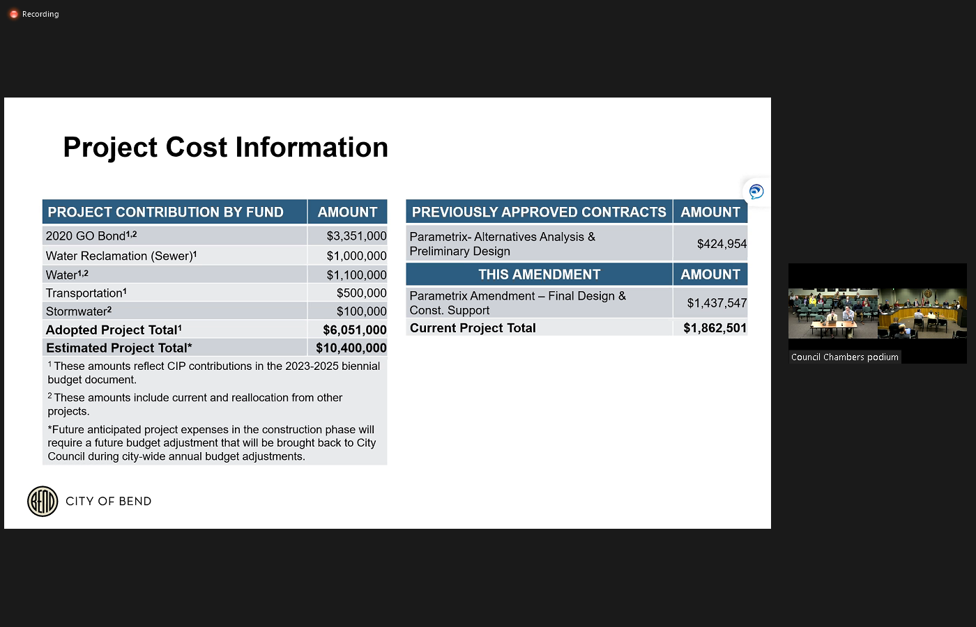
 pass someone that may be going slower and the bike lane so looking at this fourth option, part of why we're able to do this or looking to do this is because of synergy projects. We do have water line work and sewer line work that needs upgrading on this project. And so just leveraging that funding again, and that's shown here on this map so the limits of the water and sewer work. And then a little bit on funding Russ spoke to this a little earlier but we are anticipating about another million and then bond money for this to get us to this 10 point 4 million that we're estimating for our total project cost and currently, we're around 6 million for funding and so that additional funding for from the geo bond as well as the synergy projects that we'll come back for in the future. And so yeah, the amendment for tonight we're looking for phase two for final design and construction support services of 1,437,547. A bit on the schedule. We're looking to complete final design in 2024 and then move into work on franchise utilities and construction in 2025. Eight questions right.
+1
Yeah, thank you. I'm Carrie with the engineering and infrastructure planning department and we're here to look at the phase two amendment the only pedestrian and bicycle improvements project, specifically looking for final design and construction support services on that amendment. So a little background on the project location. You can see the project here in that tiny yellow tan circle. And it's a third of a mile pretty short segment, but important segment of a key walking and biking route. In the city. We are touching three other low stress net routes that are part of the low stress walking and biking network in the city. And I've highlighted a few other projects that are currently being prioritized by the transportation Bond Oversight Committee that are long the same key route three. So those are shown in blue and purple. And you'll see other key routes shown in green here on this map and other key route projects with funding highlighted in red. So some background on that project. It comes directly from the 2020 transportation system plan and 2020 general obligation bond. And as part of that those documents outlined for a safe crossing at only in second. So that shown kind of on the east side of this map with the teal dots, as well as protected bike lanes on only at the highway overpass and then a shared use path adjacent to the road from Wall Street to the railroad with the goals of the shared use path the to close the sidewalk gap over the railroad to remove existing barriers to East West bicycle connectivity and to mitigate right turn hook crashes and this was where we had the 2017 Fatality of Jonathan Chase Adams with that right turn hook crash so we're looking to +1
do improvements to help prevent that from happening. So some scope we are wrapping up phase one for the Alternatives Analysis and preliminary design services. And then looking to move into Phase Two for final design and construction support. As part of phase one, we conducted two open houses one being an online open house and one being an in person open house. And we developed some options as well that we shared at those open houses. So option one was our in budget transportation improvements, and that just included on st buffered bike lanes, and that kept us in budget. So we didn't look at a shared use path with that option one, option two and three when we started looking at a shared use path, as defined in our improvements it did push us out of our budget for those transportation improvements funding. We briefly considered having a shared use path on both sides of the road and that was greatly over budget. So we scaled back on that and that was due to limited right away. That was pushing that out of budget. So at the open house we heard from around 100 community members at our open houses and we had some concerns about the short segment length of a one sided shared use path. And this being like dropping someone biking into an intersection without a safe crossing at that starting point. We also heard feedback on with the shared use path different users on different modes of transportation, sharing that same space going to different directions and that not being the community's preference for a pedestrian and bike treatment and we also heard feedback on our on st buffered bike lane options, that there was concerns with this being still riding too close to vehicles and not offering substantial protection away from vehicles for cyclist. We've also been coordinating with BNSF at the rail crossing and we heard that we would need additional gates at the shared use path crossing the railroad. If there was two way ridership going both directions and the rail his preference was for keeping bikes moving in one direction on each side of the road. So based off those three options we then looked at and the feedback we got on those as well as our project teams analysis, which we had the same concerns that the community was raising. We looked at a fourth option to best leverage the funding that we have. And so that's being shared here. Now this is looking at a protected bike lane so occur protected bike lane, on each side of the road, and then sidewalk on each side of the road with the goal being to provide every user that moves at different speeds their own set space away from the other users to really add that additional safety and user experience on this road. It was some of the numbers we got for bikers on this road were some of the highest we're seeing and been so it's definitely an already used very popular route for walking and biking. So we want to make it even that much better with this project. And we're still still kind of fine tuning what that looks like in terms of measurements. You'll see some here but these are still draft measurements that we're looking at for the bike lane but we want to make it so the current protected bike lane you can have to weigh side by or not to weigh but side by side ridership and have that ability to still +2
pass someone that may be going slower and the bike lane so looking at this fourth option, part of why we're able to do this or looking to do this is because of synergy projects. We do have water line work and sewer line work that needs upgrading on this project. And so just leveraging that funding again, and that's shown here on this map so the limits of the water and sewer work. And then a little bit on funding Russ spoke to this a little earlier but we are anticipating about another million and then bond money for this to get us to this 10 point 4 million that we're estimating for our total project cost and currently, we're around 6 million for funding and so that additional funding for from the geo bond as well as the synergy projects that we'll come back for in the future. And so yeah, the amendment for tonight we're looking for phase two for final design and construction support services of 1,437,547. A bit on the schedule. We're looking to complete final design in 2024 and then move into work on franchise utilities and construction in 2025. Eight questions right. Melanie Kebler
Thank you Carrie. Yeah, questions counselors, pencil Perkins deck either
Speaker 12
just a couple slides back the synergy projects. What is your transportation needs opportunity area? Yeah.
Speaker 11
So that is an area you'll see. We're doing water and sewer work there. And our transportation the way the geo bond structure the project. It had us doing work on Second Street with the safe crossing and then it had us doing work up until first street with a shared use path. So that's kind of a gap and where the geo Bond didn't call out for improvement specifically, but the sewer and water with doing those projects is going to be tearing up the road anyways. So we'd like to build that segment of the road back to match the new improvements we're doing for transportation. Thank you. Yeah, perfect.
Melanie Kebler
Other questions, Councillor Mendez?
Ariel Mendez
Oh, I love option four. It looks fantastic. Yeah. My question is also about some of the synergy projects. There's so two synergy projects. There's this project and then the the geo bond, Portland project. They both have a boundary of Wall Street. I assume it's the Portland Ave one that includes the intersection because this one does not right.
Speaker 11
Yeah, this one includes just those the mitigation of right turn hook crashes at the intersection. So there's a small amount of the funding specifically for the intersection but it's likely not like touching signal poles at the intersection or doing major work there. So with Portland Yeah, kind of similar like tying into the intersection. Overall the intersection is not currently funded and underfunded, but called out in the TSP for additional improvements at some point
Manager King
where we'll
Mike Riley
protected bike lane Yeah, so
Speaker 11
thank you. So what are the current protected bike lanes are looking to have those be from Wall Street to Second Street. And then with this Portland segment, there's a missing bike lane. Right there. So we're getting some of the funding from Portland transferred to this project to do shared use path on the south side on Portland and as well as on st buffered bike lanes on both sides of the road. And those will kind of be tied into the improvements like crossing at Wall Street to get to the new current protected bike lanes.
Mike Riley
On A Budget are we saying there's a $4 million gap is that basically
Ryan Oster
there is yeah, that was two wrestlers earlier point. Yeah. So fortunately, in this case, three out of that 4 million is split between water and sewer. So we had programmed water and sewer funds, just not to the extent that the cost estimate is coming back as so we'll need an additional million out of the geo bond funds vacations. Yeah, and then the other three is coming out of our utilities.
Mike Riley
This is part of that bigger discussion that that's what we're gonna come to everything we wanted to do. Yeah, given price escalation so hard, moving it around to the top right.
Ryan Oster
That's the January discussion that we'll be back highlighting this and a half a dozen other projects that are all kind of in the same boat.
Melanie Kebler
It was noted on your slide carry but the our oversight committee, this is one of the priority projects they identified as well. So yeah, Councillor Campbell?
Barb Campbell
Yeah. Um, there's a business located, you know, southwest corner there of the parkway, and Animal Hospital is their entrance gonna get
Speaker 11
close, it's not gonna get closed. It's just a change. We're recommending a change in order to accommodate the current protected bike lanes and the spacing. So we have to remove the current left turn lane into that business and as part of removing that, we then run into some different design options with now you're turning left at a curve where there's limited sight lines and shifting light levels. So we see some overall there's analysis that shows that up to your risk of having left turn hook crashes for bikers. And so as part of our design we are recommending to not have left turning movements there and maintaining right in right out movements.
Barb Campbell
Okay. Thank you. I was that was I was hoping that would be the compromise. Yeah, good.
Melanie Kebler
Any other questions?
Anthony Broadman
Or motion?
Ariel Mendez
Move to authorize an amendment to the agreement with parametrics incorporated in substantially the form presented to council for final design and construction support services of the only pedestrian and bicycle improvements project and an amount not to exceed $1,437,547 Second.
Melanie Kebler
All right, moving, seconded. All those in favor? Aye. Great, thank you so much. Great work. Excited to see that moving forward. Yes, you too. All right, and then moving on to Item eight. So that's announced
Speaker 6
an agreement with David Evans and Associates ng for design services for the Crosstown bikeways bend Parkway project. By with whatever we got, yeah. All right, Ryan.
Ryan Oster
Okay, perfect. So well, Kevin's connecting and bringing that up just to frame this up a little bit. I know a lot of folks here are already familiar with this. But for others that might be listening. The intent of this project is in honor of Halloween. It's a bit of a Frankenstein project, right. So we've got a lot of other projects, whether it be Butler market or Bear Creek or Midtown crossing and all these Greenway projects. This is intended to fill the gaps that the TSP and the geo bond won't allow us to spend like geo bond money on so Kevin is going to show a map here in a little bit. And this is specifically driven at delivering Council's goal of one north south and one East West connected and protected, preferably key route. So yeah, it's a bit unique in terms of how we had to scope this. You know, our poor consultant, you know, it's like, yeah, we're gonna have you do this, but it might change tomorrow. So he you know, so we're coming to you tonight with a scope of work to really get this thing going and get the consultant team on board so we can really start diving into the alternatives. And then ultimately, you know, we'll be back for any decision level authority, things we have, as well as again, it's most likely going to include some level of a budget adjustment that we'll hit in more detail in January. So with that,
Unknown Speaker
added over, yeah,
Kevin Howard
thank you, Ryan. Council, Kevin Howard. I'm a Project Engineer with the engineering and infrastructure planning department. Presenting tonight on the professional services agreement with David Evans and associates that will help us identify select and design walking and biking improvements for the Crosstown bikeways or bend bikeway project. This is a traditionally procured project so David Evans and Associates was selected through a qualifications based proposal scoring process. Some quick background there's two main types of routes included in this project. There's the crosstown routes, which are the purple and orange routes shown on the map. These the ones that Ryan alluded or are directly linked to implementing Council's goal building the one connected and protected north south and one East West key route. And again, these routes shown on the map were the routes that were approved by city council in the June 21. This year work session. Work along these routes is funded by the transportation capital improvement program, and a surplus transportation Block Grant. Additionally, there's the nine streets route which is the green route shown on the map. This will construct a shared use path adjacent the Ninth Street between Newmarket road and Wilson Avenue and work along these routes is funded by the 2020 transportation general obligation bond.
Kevin Howard
Quick overview of the scope of services including this contract. Right off the bat we plan to have a pretty front heavy portion of the design that's this preliminary studies and Alternatives Analysis. This is where we will consider multimodal needs and opportunities along the entirety of the crosstown routes and then incorporate public feedback and ultimately identify our preferred alternatives that we will progress into final engineering the plan conclusion or near the conclusion of this Alternatives Analysis. We'll come back for a council work session and present our findings. It's tentatively planned for spring next year and we'll talk more about that work session later on. Contract also includes support for public outreach survey mapping, utility coordination and permanent support as well as final engineering services to 100% design and support with pre bid and enter Inner Engineering of record services. So this contract does offer the ability to produce documents that are ready for construction, as well as offer support throughout construction without requiring a future amendment.
Manager King
Excuse me.
Kevin Howard
So the scope of the final engineering services that we have currently included in this contract are shown here. This is kind of based around the what we currently believe to be the minimum level of improvements required to meet the associated Council goal. And again, the the full extent of these will be determined and the Alternatives Analysis, but for the basis of scoping, the scope of work and the fee associated with this contract. We're currently anticipating there to be three different shared use path corridors, three different neighborhood Greenway corridors, one enhanced intersection crossing, accessibility improvements and modal filters to be determined through the Alternatives Analysis and wayfinding signage along with the majority of these routes. also noted here is a fairly notable omission from the final engineering scope of services which is the butler market and Boyd acres Road intersection. We will consider this in our conceptual design. But due to the high volume of the signal controlled intersection, we've recognized that we're not going to be able to make any meaningful improvements with the pre approved financial resources that we have for this project. So while we will consider options we know we can't afford do an offer any sort of design there'll be close to 100% with this contract. Quick overview of the schedule. Starting with tonight's approval the contract. There'll be a continuous 19 month schedule for design and construction. Of these routes. And this the conclusion of construction is you know there's the line with the council goal and date of June of 2025.
Kevin Howard
So, you know, again, our first phase of the design is the Alternatives Analysis portion. And near the end of that we would plan to come back for a council work session to share the findings. Part of that there doesn't indicate that there's Council action associated with that work session and because of this contract clewd services for 100% design of the items I mentioned in the last slide. There isn't there won't be any sort of action required to to complete the design of the items that are included here. But really just want to make sure that our design is progressing in a way that will help fulfill the council goal. We also plan to share our revised cost estimates for constructing the the final engineering items that we have included in this contract at that meeting and and discuss some different options for possibly offering a higher level of service along these routes. Yeah, and then again to help us stay on track to complete these improvements by the end of June of 2025. We plan to have a hammer construction documents out to bid around this time next year. Quick overview of the budget for this project. The table on the left represents the pre approved financial resources for this project. As I mentioned earlier, the work along the crosstown routes is funded by the transportation capital improvement program and a Surface Transportation block grant and then work along the nine streets out is funded by the 2020 transportation general obligation but under
Kevin Howard
the table on the right side simply shows the amount of tonight's contract with David Evans and Associates and then highlights the remaining money under the construction item in this $1.7 million is simply the remaining budget that we currently have for construction after subtracting out tonight's contract. We recognize that construction of the items that are currently included for final engineering which again are kind of what we currently believe to represent the minimum level of improvements required to meet Council's goal would have a higher cop construction costs and this $1.7 million so this is kind of back to that work session we plan on sharing the updated construction cost estimate.
Ryan Oster
If you don't mind, Kevin, I'll be referring to here real quick. I know when counsel was prepping for this evening some questions came up about the Ninth Street effort. So you can see as Kevin highlighted on the left side of the slide there that 1.1 That is geo bond money that can only be spent on nine streets. We can't move that somewhere else based on what we committed to in front of the voters. So when we talk about we have 1.7 million for construction 1.1 of that is going to Ninth Street that only leaves another five to 600 grand to do everything else that Kevin's highlighting tonight. So again, bringing up that bigger point, we're going to come back to you with some options. I'm kind of a buffet style like this is what we can do within budget. This is what we can do with a little bit more budget over here versus over here. And ultimately kind of you know, whichever whatever council would like to read resource that is what we'll
Manager King
we'll move forward with and I think the timing just going putting the puzzle piece together that Russ mentioned. So January kind of a work session that looks in totality at the transportation construction program. And so I think this will probably come after that. So I think you'll want we want to, you'll want to think about the prioritization of projects within our CIP. That fold in the geo bond transportation construction fund. STC funds all of that together so that you can understand what capacity and where you might want to prioritize those funds for this work session that would follow.
Barb Campbell
That'll be the easy meeting
Melanie Kebler
browser. Oh. Do you have any other slides or is that in budget? That's it. Okay. Picture. Yeah. Yeah, it's nine. St. definitely needs some work. That segment so Okay. Any questions counsel for staff? Councilman does. Thank you.
Ariel Mendez
It's tremendously exciting to see this taking shape. I mean, we've heard tonight from you know, it's part of the Envision bend work has been identified. This is this is climate action. This is safety. This is congestion relief, all things that bend really needs as we move ahead. So thank you for your work on it. The area that I wanted to ask you about was the scope of work contract has some language in it describing some up to four modal filters up to two enhanced crossings. That doesn't mean that this is only going to have up to four modal filters or up to two safer enhanced crossings. So could you explain a little bit about how that works and how Yeah, we'll have an opportunity to make sure that absolutely, that work really has the Yeah, so
Ryan Oster
in working with our consultant we have we have to pick a number so they can put a price to it. So we build in contingency to all of these contracts though, and so we have flexibility even within the scope of work and it within the language of that contract. If as we lay out these alternatives, and we're looking at different areas, it may point us to six modal filters and five enhanced crossings. And that's what we'd be bringing back to you so that language doesn't limit us to only doing that. It's just a point in time. So our consultant has a number to give us. So but yeah, we've got flexibility to explore.
Melanie Kebler
Great, thank you. Other questions?
Unknown Speaker
That's great. So,
Unknown Speaker
Robin, was there something that you wanted to
Unknown Speaker
bring up here?
Anthony Broadman
Yeah, I just want to share an email we got to council and I just want to make sure the public hears it and it's more of appreciation for all the hard work I think that staff is doing. It's from David Berger. I wanted to share with you about my family's experience. We lost Trenton Berger, my 15 year old son who was riding an E-bike, hit by a car and killed in June of this year and Bend, he was a kind, loving soul, a friend, a brother and uncle and a grandson to those who knew him. We will never get to see you talk to, or even hug him again. I want to help and support ebike, bike safety, and infrastructure to keep other families from going through this tragic experience. Please build the infrastructure we need to ensure that our children are safe. The Bend Bikeway before you tonight is part of ensuring that kids can get around our community independently and safely. It's good for our climate, our kids development and our transportation system. But we need to hold ourselves to a higher standard as a community to ensure our kids are safe. I commend the efforts to legislate more around ebike safety and clarify the rules. I plan to support those efforts. This issue has many facets and we need to address it from all aspects, building the bend bikeway and designing it so that it works. So that is used by all kinds of people and is maintained well, will make kids in our community safer. This is one thing the city can do to honor Trenton and the lives we have lost in our community. Thank you for your time David W Berger. And you know we heard about Mr. Adams who was killed On the panel on the improvement that we're doing tonight, we heard from Annie Goldener, losing her son in the last meeting. And so we know what the stakes are. And I'm really grateful to you for working with us.
Melanie Kebler
Yeah. Thank you. Yeah. All right. We're ready for our motion.
Ariel Mendez
Yeah, I just want to suggest that it's just to make sure that we have the flexibility that we want in this contract that I'm going to propose an amendment just to authorize the city manager to have a contingency of up to 10% so that he has the flexibility ahead of time to make a judgement about changing the scope of the the agreement, if necessary.
Melanie Kebler
Discussion on that 10% would be 78 grand.
Ariel Mendez
So we should make the motion and then I should
Melanie Kebler
propose Well, I mean, I think we can discuss a little bit. Yeah, just to do that.
Ryan Oster
So as my colleague pointed out to me, we basically we already have Eric already has the authority to go up to $100,000 and change orders and amendments without just in general on almost any contract. So we you could do that if you wanted to formalize it and you don't have to, you know, the city manager already has that authority. So I spoke a little 70. That's an option.
Melanie Kebler
But you don't I think I can join and Councilman isn't wanting to make sure that you feel empowered and the consultant feels a power to explore a lot of options that are really going to promote safety, that you don't feel like well, we shouldn't look at that because it might be a little bit more expensive. We or Hey, shoot, we've already done all these alternatives. Can we do one more? We just, I think want to express we want you to do that. So we want this to be really high standard, so. Okay, thank you. Go ahead.
Ariel Mendez
I moved to authorize an agreement with David Evans and Associates incorporated and substantially the form presented to council for design services of the Crosstown bikeways bend bikeway project in the amount not to exceed $786,820 Second.
Melanie Kebler
All right, moved and seconded. All those in favor. All right. Thank you very much, Kevin. And Ryan, thank
Mike Riley
you for having us. Thank you.
Melanie Kebler
All right, turning to Eric being for item number nine Sheila.
Speaker 6
Resolution amending Council University T 007 to affirm the city's commitment, non discrimination in the use of discretionary funding for community programs, services and events.
Manager King
So I'll cover the presentation on this one. So as you know the city's discretionary funding and sponsorship community programs policy was adopted by resolution in 2016. As the policy established clear standards and discretion for discretionary funding of local initiatives that serve a public purpose and align with council goals. The amendments that's before you tonight affirms the city's commitment to using discretionary funds for non discriminatory purposes and clarifies the definition of public purpose to include additional protected classes. As you know, we had a work session where we talked about the human rights and equity commission work plan and within that context, we talked about the need for additional protections in the sponsorship policy that's before you tonight. So we're just following through on the general direction of support we got from council there. So this amendment also does change the word Christmas parade to holiday parade to reflect the policies prohibition on promoting religious purposes. So it's just a real broad summary. I'm happy to answer any questions. We have staff here too. There's more technical legal things that I can't address.
Melanie Kebler
Yeah. And there was a redline in our materials that shows you all the changes and Hunter as presented on this previously.
Manager King
But should mention too, we have there's the policy pieces before you tonight, but as we talked about with council, we also want to more from an administrative perspective, really improve safety planning for events so that we can assist both event promoters as well as those that are attending the events to make sure that all of our events that are funded with public funds are safe and welcoming for all people invent. So there's still more work to do with just some administrative things. This policy though, helps just again to reaffirm our commitment,
Mike Riley
that part about the safety plan is going to be taken care of through the permitting. Department to the permits. Yeah.
Barb Campbell
Great. This year's parade has already been planned and advertised and will be a Christmas parade. Not a holiday parade. Is that right?
Manager King
And that's still fine. I think that
Barb Campbell
I had it's late days. I understand that you know, that these things. A lot of these people seem to have at the start and in the summer time for not everybody procrastinates like I do and and so then do we have any kind of jurisdiction over who is allowed to participate in this year's parade?
Manager King
So we as you've said, we've already have an application for our sponsorship policy had made reference to a Christmas parade and those folks applied under that we do have language in our existing policy to really help us reinforce some of that and this I think this action by council also helps us for for future events to to make sure that that is as tight as can be.
Melanie Kebler
Yeah, I mean it previous what we're doing is strengthening and previously, the policy always said, you know, no discrimination, but this is making it stronger. So I think it's still there. And we want everyone to feel like they can participate and they can attend and they can feel safe doing that. Right. So.
Anthony Broadman
Okay. That's your question. Okay. So, okay, so next year. What will the prey be called?
Melanie Kebler
Our sponsorship is calling a holiday parade
Unknown Speaker
will sponsor a holiday, right?
Manager King
So, right it's up to the organizer to sort of ensure that the however they're putting the parade on complies with our sponsorship policy. So but for our purposes, we're calling it because that's consistent with what you know our city's broken mission on promoting religious purposes. He
Speaker 13
says that she does not promote a particular religion. We always said that you could never promote a particular religion. So you couldn't say I'm doing only a Christian parade or only a Jewish parade. You could never do that. That doesn't mean that you can't have something in your parade of any religious background. You just can't say that. That is what you are promoting as the event organizer. We will next year call it we will say it's the council decided when it did this this sponsorship policy to have a number of events that council was going to sponsor the veterans parade, parade that was always called the Christmas parade. So that's what we put in the sponsorship chip policy. We felt that that is somewhat inconsistent to call it a Christmas parade when our policy itself says that it can't promote a particular religion and Christmas is more associated with a particular religion. So we thought we should call it a holiday parade the council is sponsoring. We didn't do it this year in time to change what you were sponsoring. So that's fine. But in there, it will be sponsoring a holiday parade
Melanie Kebler
and their city sponsored events some just to be clear, not Council sponsored.
Speaker 13
Yes city. Council chose sure bouncer and events that you were sponsoring as a city.
Melanie Kebler
And we have in recent years added Juneteenth added you know pride to the administrative policy right. So and this is a list it says includes but it's not exclusive. So there are other events we could
Speaker 12
write but is this the only one that is sort of in the hopper right now that wouldn't be impacted by this adoption? Yeah.
Melanie Kebler
It's the only one. Yes. Yeah. Got it.
Unknown Speaker
There was a timing was amended months ago.
Barb Campbell
Probably yeah. So just put a really fine point on it. If I want to create a float, that is the solstice flow chart, the Hanukkah flow, and I want it to be in this year's Christmas parade. The organizer of this year's Christmas parade could tell me no. Okay, great. That's what I wanted to know. Okay, great. Great. So as for me, yeah, I'm not thrilled that it's still called the Christmas parade, quite frankly, in 2023. Seems kind of archaic to me. But I understand that that is what has been permitted. So as long as I now to feel confident that the organizers are not going to turn any reasonable requests for a float, and maybe even unreason, but. Right, well, I'm gonna let the Christmas thing slide this year. And we're gonna kit and next year we have a holiday parade.
Melanie Kebler
Correct. And just to be clear, our our previous policy already said, right, you use it for a public purpose and you can't discriminate based on religious affiliation, and you can't promote a particular religion so that's already there. Great. Strengthening this Yep. Now, great, thank you just care about this.
Speaker 12
Someone were to feel that they were excluded based on one of these things. What, what, what can they do? What is their process?
Speaker 13
We should talk. I mean, I don't want to speculate on what might happen. Yes. So I think somebody had an issue, they should come talk to the city and ask about their particular with the city. Do you think they should? They should talk to the city manager.
Manager King
Okay. Thank you. It's hard for me
Unknown Speaker
to talk directly to us and then we need
Unknown Speaker
to get that out there.
Speaker 13
And then we've looked at our policy and we look at actually what is happening and talk to me about it that's needed to
Manager King
the fact where an event like this might be permitted. There's still resources that the city commits to by sponsoring that haven't been deployed. And so we want to make sure there's that extra check to make sure that we're complying with our policies to before we deploy public resources.
Barb Campbell
Yes, good.
Mike Riley
The permit will probably already doesn't make clear but it'll continue to make clear if not clear that it has to comply with the public purpose as amended on this date. Right. I mean, just for future.
Speaker 13
Thank you. But that's our permit doesn't do that. Now, for any of our events. My understanding, we have a permitting process that we've been doing for a long time. So we have some internal work to do with our permitting process and our
Mike Riley
maybe I mean, our Sponsorship Agreement. Do we not have a because that's what this is really about?
Melanie Kebler
Right? And I think sponsor and anything is fine for us to kind of all say, please do that internal so that this is linked to the perimeter so that people know that it takes us
Mike Riley
Yeah, yeah. And if you're agreeing to get sponsorship from the city, you're following these kind of concepts which are laid out in the policy over here because if not, if you don't do that, we're not following through on the resources. The agreement. Yeah. Okay.
Speaker 12
Motion, I move to adopt a resolution amending Council policy number cp 007 to affirm the city's commitment to non discrimination in the use of discretionary funding for community programs, services and events.
Melanie Kebler
Second, all right, moved and seconded.
Anthony Broadman
Just to comment I mean, I'm I'm very in favor of eliminating any discriminatory provisions. I was not aware of the impact that would have to the name of the parade, and I would have liked to have had more time to consider that. I understand the purpose behind it. And I'm going to vote yes. But I would have liked to have had a more robust conversation about the name of the parade given the tradition in our community that I've served.
Melanie Kebler
Okay. It was in our materials, but,
Barb Campbell
but it could have a Christmas parade. We just wouldn't sponsor that. No,
Manager King
maybe so, you can call the parade it could be another religion. It doesn't matter. I think what we're trying to do is just clean up the large house we're not seeing we're not picking a particular one. We're saying any could be called the Christmas parade for, you know, the next one, and that depending on who the sponsor is, we're just saying we're not committing ourselves to only being a Christmas parade. It's a holiday parade to be consistent with her. Yeah. Other policies
Unknown Speaker
to help. Yes, okay. Okay.
Melanie Kebler
Good. All right. It's been moved and seconded. Let's vote. All those in favor, aye. All right. Great. Unanimous. Thank you. Thank you for the questions and clarifications. And thank you for working on the start. All right. We are moving on to to counsel actions and reports. Do we have any subcommittee updates that we want to mention? I think we kind of touched on. We're covered. Okay. So counselor Riley, do you want to kick us off?
Mike Riley
Sure. I am and I'm set it on the first beat AB meeting that was discussing the top so it was a good overview and introduction to the concept and I think gave some general direction about you know, sticking with that kind of middle road, if you will, where there's some buckets, but understanding there, you know, we're not getting too detailed, and it's not too general in terms of how we figure out what the fees are going to be for various type of commercial entities in the community. And express that at least for me, and I thought generally the council direction was about, you know, wanting to be grounded in data and evidence and somewhat consistent with the way the STC methodology is moving forward around impact and that if they wanted to make recommendation that was very different from that they need to have a very clear rationale about why and probably give us an up an option there. And then the mayor and I were both at the tough neighborhood meeting that happened at Summit High School. We could go today I think and it was Summit West and century West and one other neighborhood group. And I review it Yeah, there was about 65 people there. I think we had a lot of good questions and discussion and people's people stayed afterwards of Yeah, that's what I have to report. Okay.
Melanie Kebler
Counselor, Norris.
Speaker 7
I also attended that meeting and I thought it was you know, really good dialogue and, you know, chance for our neighborhood associations to get more involved and have more of a public presence in addition to the roundtables that we had, so it was nice to hear from residential communities. And then I attended the Oregon homebuilder conference which is that very insightful and really giving a good you know, update on where the markets where we're at in our home production and talking a lot about some of the legislative policies that we can, you know, be supporting in order to increase more housing and affordable housing. And that's it. Okay, thank you. Can I add one
Melanie Kebler
thing? No.
Mike Riley
I went to the IMPACT Conference, the Chamber sponsored yesterday, and I just wanted to say a big thank you to Brian Rankin for presenting as part of the policy discussion and sort of taking a lot of big topics and boiling them down and I think delivering an effective way for the community.
Melanie Kebler
Got it. Thanks, Robin. Nothing to report. All right, Councilman Davis.
Ariel Mendez
Yeah, the two items coming out of the bend MPO. One is if the state is conducting a tribal survey, mailing out surveys to several 100,000 households in the state. So if you receive one, it is legitimate, please participate. Getting household transportation information is really important to the work that we do and good news, the MPO was awarded a $200,000 grant from the federal safe streets and roads for all program to update the Ben Transportation Safety Action Plan. I'm really excited about this because we're able to use so many of the values that we important things like looking at transportation through an equity lens, looking at how to incorporate new technology, things like cameras to be proactive and making our roads safer. Lots of good stuff in that so that's really great news. I also met with fire chief Todd Riley and Deputy Chief Jason Bolin. Last week to ask about emergency vehicle needs in making our streets safer and lots of good news on that front. In particular,
Anthony Broadman
speed limits.
Ariel Mendez
slow speed limits are perfectly compatible with fast response times. Not big fans of speed bumps but they like speed humps, which can also be really effective. Things like modal filters and diapers are compatible with fast responses as long as we incorporate a sufficient planning process to communicate routes. So that was a great meeting. And last week I the same night that the tough meeting roundtable happened now table Excuse me. Town Hall town hall. Thank you. I met with the Riverwest neighborhood district and Ryan Oster join join me as well and had a great turnout. Lots of focus on safety. People really want to make their streets in their neighborhoods safer and good conversation about the future of Galveston. So that's it
Melanie Kebler
right. All right, Councillor Campbell?
Barb Campbell
Councillor Mendez did a great job reporting on the MPO meeting. So I'll pass
Melanie Kebler
all right on counselor Birkin syrup.
Speaker 12
Wow wasn't right for that counselor really did a great job with beat up so I'll leave that there. At Human Rights Equity commission, talked about there are one and put in a plug there. Are openings on a lot of our committees and commissions. I don't know when the I think
Melanie Kebler
it might have passed. Okay. We did there were opening applications. We did.
Speaker 12
We did. Yes. So that was part of the conversation was transitions because that there's a lot of people on the on the commission. That are their terms are are ending I think in December, and the Commission was able to hear sort of our what the results of our work session and talking about diversity also virtually attended the core area Advisory Board meeting where they had a update on the the assistance program, the development assistance and business assistance programs and also an overview of the infrastructure projects in the in the Corps and that was a it was a really great discussion and then virtually attended the coordinator homelessness Response Office meeting, and we talked a little bit more about the MOU between the county and CIC and talking about also the future hiring for because we've had a halftime person for the last a bunch of months now for for the coordinating office, talked about how we're going to move that forward. Heard a great presentation from our city. On our navigation center. And then I talked a little bit about what the roundtable process is going to be for the public lands and finding manage camp and how that's going to be moving forward and that is evolving but but things are moving forward and we should be really leaning into that work and being able to bring some information and get some feedback from the public soon.
Melanie Kebler
Great. Thank you and thank you for continuing to represent us on the CHRO that is a lot of work. So for my highlights I went to a couple of things people will also mentioned earlier the Oregon homebuilders Association, did some brief welcoming remarks got to talk about some of the work we're doing and then heard all the very interesting and good information about where the markets at and what some of the barriers are. The there were several elections there are two or three of our elected delegation was there and the governor zoomed in face is really big on a screen and answer some questions as well. And I think this continues to be a huge priority for her and for Salem. So also attended the chamber IMPACT Conference, some really interesting presentations on the state of the economy, both generally and for the real estate market. So thank you to the chamber for putting that on. Went to the transportation feed townhall discussion, and we'll just follow up with saying, you know, thank you to staff for coming in being available and answering questions and I think we got some good positive comments. Again, similar to our last one. Now I understand more about why we're doing this right. may still have concerns but at least people have information. So that was great. Monday, I went to Salem to meet with the mayors of the other seven midsize cities, every woman was able to be there except for the mayor of Gresham. And we were talking about revenue and city tax structure and property tax structure and how we are all feeling those problems that are inherent in our tax structure. And if anyone read the bulletin this morning, they have an editorial on the housing production Advisory Council identifying the same things. How do cities pay for infrastructure? How do they keep up with growth, given our restrictions on property taxes, and that's a general thing for us and also really tied to housing. So the discussion was those mayors was how do we start talking about this and getting some ideas put forward on the state level to think about changing this in a way that helps cities do what they're supposed to do in a functional way. And so that was great. So beyond that, I think I emailed earlier about a letter. As people may know, there was a horrific, horrific shooting in Maine. One of the many mass shootings that happens in this country way, way too often. And too many people's lives lost again, there is movement across the country to crush our federal leaders. To do something about this. And so I've received a request from the mayor of New York as part of the every town, you know, movement against gun violence to make a specific ask to Congress and unless there's objection, I'll plan on signing that and asking that'd be shared widely. I think Council already said let's share it with both sides of Congress. I agree. So we I will do that. Unless there's any objection. And then we have a scheduling requests that we've moved here to the end that council abroad and has for us.
Anthony Broadman
Yes, I would request an agenda item on tolling the expiration for building and land use permits within the authority of the city. We got a letter about it. I think we should talk about
Melanie Kebler
it. Okay. Does anyone have any you want to clarify or just add a little bit more context? Well,
Anthony Broadman
I mean, there's a lot of reasons why it could be I mean, we should talk about in an actual session if people want to talk about it. See, have permits that may expire that then city staff is going to have to pick back up and reevaluate fresh rather than tolling them the reality from my attendance mayor's attendance counseling horses attendance. At the Oregon homebuilders association is that the cost of construction, the wildly volatile housing market right now, especially with multifamily is slowing down a lot of this construction and I would defer to Councillor Norris's expertise on this and it seems inefficient to have these permits, particular permits be reevaluated again. If they're set to expire in say six months when we know we want these projects to happen. There's a lot of other good reasons to that. I think we can dive in more deeply. I do think it's worth us. Considering, you know, are some of these projects going to break ground because the permanent is going to expire? And that's a balancing test that we should apply as a matter of policy, but I think it's at least worth discussing.
Melanie Kebler
Yeah. And I saw one of our smaller developers at the IMPACT Conference and just mentioned this to him. And he was talking about how he's having a very hard time getting a construction loan right now. And so he's about to go ask for an extension on his permits, because he's still working on the financing. And a lot of that has to do with high interest rates in the market. So when I mentioned this, he said yes, this would be helpful to keep this project alive and keep him looking for that. That finance and there's we've done it before. Yeah, Eric, I don't know if you want to talk about sort of precedent on this.
Manager King
Yeah. So we did this in 2008 2009 timeframe when we had the great recession. And a lot of folks you know, that was pretty tumultuous time and then as part of emergency declaration work with COVID When we're there's just a lot of uncertainty. There was some extensions that were granted there as well.
Melanie Kebler
Yeah. So would it would there be staff capacity to bring this back just a proposal?
Manager King
Yeah, I think we should talk about it and how we do it. And I think the findings that you mentioned, like I think what we want to do is build the case for that. And that would be a work session to help us articulate the reasons why, but it'd be most likely in the form of a resolution.
Anthony Broadman
Yeah. And if counsel wants to, I mean, I think we should
Speaker 13
talk more about it. I do want to talk about the use of your emergency power for this kind. of thing. It is not the concept of doing it. I think you need to talk about it. And if you want to do it, I do want to think about the mechanism. Whether we didn't do
Manager King
an emergency in 2008. That was done just by resolution. We did that emergent.
Unknown Speaker
Yeah, that makes sense. I
Speaker 13
think about using resolutions to regulate, it would really want to his regular use other ways of having a cold at sunset so we can talk about the mechanism of how to work session about stack just a little bit more about the best way to do that if that's what you want to do. But first you want to have to want to do
Melanie Kebler
it. Yeah, counsel. Any thoughts? Yeah. Sorry, go ahead.
Speaker 7
No, no, I just wouldn't be supportive and just echo especially in the multifamily. The cost to go vertical are just so expensive in the early cumbersome with the high interest rates as we noted, and to not have to get back in the queue, you know, after you know, with an expiring permit and have to you know, save time on that schedules. You know.
Mike Riley
We heard a lot about the interest rate environment at the impact conference yesterday, and I'm sure you guys did the other thing you were at, and how important that is. I think it's a really important conversation to have and it's really bad. I think I also just want to make sure we're talking about like, what are the downsides and sort of looking to you guys to be able to talk us through that so that we get a full discussion, right, the pros and the cons and, and kind of weigh all that and as we go through this, it's important for us to consider all those things.
Melanie Kebler
Okay, sounds like you want to have a discussion. So let's get that planned.
Manager King
Yes, and the challenge. It will have to we've got some scheduling challenges, but we'll figure that out.
Melanie Kebler
Okay, thank you. Yeah, yeah, city
Manager King
manager's report. Oh, yeah. Just a couple of events. The climate friendly areas. We have an Open House next week. It's at the Environmental Center. And that's on Tuesday at 5pm. So it's a chance for the public to kind of weigh in, you've heard some of that describe. We had some of that at the community building subcommittee, and that'll be coming back in front of Council. November 7, next Tuesday, from five to seven. There's also an event tomorrow for Habitat for Humanity. They have a campaign a kind of a celebration for their capital campaign to raise $4 million to build 40 homes to throw out they would love to have counselor if you can attend. It's from five o'clock on I think they're sort of open ended and date are in time. And then just a couple of updates on some construction projects. So we are progressing on our Aubrey buttes. Water Project stormwater, there's lots of things that we're doing both stormwater and water line replacements. So Main Street is now closed. There's a short segment from Newport to Portland, that will be closed for about four weeks and then there's going to be closures on moving up Ninth Street as it turns into 12. But there'll be flaggers that will still allow traffic so just a little more disruption in that area for the next couple of weeks while we still can dig in the ground before winter sets in. Wilson. So the next stage of the Wilson Avenue corridor project began on November 6, will begin on November 6, with a road closure impacting westbound traffic between Hill and South East Ninth Street. There was already a westbound closure from fourth and ninth street but now it's being extended further towards the old mill and a closure is scheduled to last through June of 2024. So that's a big one and then nothing percent some on the other side of that that project we are paving was completed this week for both the per cell extension as well as the intersection. So now we are working to get the striping down hopefully doesn't get too rainy and stormy. We have some new signal poles that are being installed and tested by ODOT. So that you know ODOT maintains that that work. We hope to have the intersection short open shortly after November 28. So
Melanie Kebler
can I ask there was a email that we got about a little missing sidewalk? I don't know staff saw that I'm sorry. I didn't forward it. Someone right there in that neighborhood that was asking, Hey, can we just get this completed? I'll forward it on. I'm just wondering if there was just like a little gap
Manager King
that there's any chance to be completed sidewalk is part of that project.
Melanie Kebler
So I'll try to find out more about what that was. Okay. Yeah. And try to see if we can get that done. That's great. But that's going to be open soon. Yay.
Speaker 13
Okay, to recap on the performance evaluation or internet.
Melanie Kebler
Oh, yes. Sorry. I apologize. I'm gonna go get it. So during our executive session today, we went in for the purpose of evaluating our only other employee, which is Judge Rocco, our municipal court judge, Councillor Campbell and I took the task of attending court sessions we talked with employees and the court and judge herself about the court in her performance and on our determination that Judge Rocco is demonstrating a high level of performance and excellent service to the community. We're going to work with staff on proposed amendments to her contract to recognize that performance and those amendments are going to be on the agenda at the next meeting and we will have a public discussion about that and renewing her contract. So thank you for the reminder Mary Okay. Move to adjourn. Thank you.