Loading...
Highland Park City Council, part 2
Unknown Speaker
In Progress
Unknown Speaker
okay
Speaker 1
20 chair will entertain a motion to reconvene our session
Speaker 1
floor is open or reconvene the motion for that please. Motion to reconvene all those in favor Aye. A 24 general session is continuing at this point we are under Section six under legal City Council after conversation is held in closed session the floor is open for you to decide how we act next on the issue brought to us by the legal department. So we move in tonight
Unknown Speaker
No no, you're moving just cut this covered the agenda.
Speaker 1
We want item seven administration and resolution to apply for the fiscal year. 2025 congressionally directed spending Council What's your pleasure?
Unknown Speaker
Without voting on the closed session today,
Speaker 1
that's under item it's an item nine. You read it please resolution to a province. Okay, moving on a seven resolution to apply for the fiscal year 2025 congressionally directed spending.
Speaker 2
I'll make a motion for the resolution to apply for fiscal year 2025 congressional direction spending.
Speaker 1
We have a motion on the floor to approve item seven under the resolution to apply for fiscal year 2025. Congressional directed spending. Motion is made by counsel Mark do we have support
Unknown Speaker
support request?
Unknown Speaker
support offered by Mr. Shafi. What are those questions sir?
Unknown Speaker
Oh, we'll be using this particular money on a vacation. St. Peter's $1.2 million as the Three Tenors are $469,000.
Unknown Speaker
What is the money for us the question I want to know
Unknown Speaker
that question is directed at home sir
Unknown Speaker
and whoever can answer you can answer it if you like.
Unknown Speaker
Work for city council, Sir, I don't do great.
Speaker 3
Well, again, I like to know what the money is for. I know somebody can tell me that answer. Looks like all I'm saying is this for the police station
Speaker 4
and it looks like it's for a new roof on the Hamilton Street building and to build a jail inside the bill.
Speaker 1
It's right on the pages man a protest. wondering
Speaker 5
did you have are these grants Why did you vote on when was the last?
Unknown Speaker
Question is for
Unknown Speaker
that man.
Unknown Speaker
And she's conveniently not here
Unknown Speaker
okay, got a whole day got really good shrimp.
Unknown Speaker
to city council. This is up to you how you want to dispose it this
Unknown Speaker
is just an application.
Unknown Speaker
is not a
Speaker 6
request. It's not You're not accepting it. You haven't got it. It's an application. So you're combining applications for the conference. So request one a Gary Peters at 100 then adopt all
Speaker 7
so basically, we're just requesting permission to seek out grants to operate the building and construct the jail
Unknown Speaker
at the end of the building.
Speaker 7
We haven't received any, any, you know positive news or any confirmation of any grant yet. We need we need your permission to seek those grants.
Unknown Speaker
Additional questions
Unknown Speaker
we have a motion on the floor.
Unknown Speaker
Yes, ma'am.
Speaker 8
The mayor is here. I'm finished with my activity. What was the question?
Speaker 1
No, Madam Mayor, the questions related to the resolution that's in front of us with all of the application criteria already spelled out in the document. It's right here. So there's really no additional questions to ask. The actual resolution says resolution to apply for and then it's spelled out in the actual resolution. I thought it was pretty transparent. That's the
Speaker 5
resolution in one. It's not so these graphs and these ads combined.
Speaker 8
There is one resolution one resolution to apply for two separate grants to the government, Gary Peters office, and Sri Tana DARS office.
Unknown Speaker
believe
Speaker 7
they're both fast approaching. I'd have to confirm with Mr. Burgess. But I do know they're there. The deadlines are fast approaching. And the whole idea behind this is is you know it's a city owned building. You know, with grant money we can fix it take the burden off the citizens. Regardless, we own the building. We got to fix it anyway. In terms of building the jail. I don't want people to have the misconception that we're building this huge. You know, this huge project that's going to be a separate building. It's literally five to six cells within that building. That would be similar to what we have. That would just be better quality, you know, better conditions for any prisoners that we have in custody and ultimately safer in terms of monitoring the prisoners and safer for the officers. In terms of transporting the prisoners. Our current jail does not have restroom facilities within each cell. So we're constantly taking prisoners out of the cell, which exposes liability and dangerous to to not only officers but to the prisoners themselves. So the whole idea is to construct something that that is modern, that that meets the DOJ expectations and something that reduces the liability of the city of Highland Park.
Speaker 7
All at the cost of grants. We're not trying to put this on the backs of the citizens.
Speaker 1
Additional questions? Hearing none, Madam Deputy Clerk would you call it a roll on item seven. We have a motion on the floor by Councilwoman Martin supported by Councilman Shafi that is sue the resolution to apply for the fiscal year 2025 congressionally directed spending grants from our elected officials if you will, please call the roll.
Speaker 9
Councilmember Shafi? Yes. Councilwoman Martin. Yes. Council Pro Tem Robinson No. Council President Thomas.
Speaker 1
Yes, motion carries. Thank you very much. Moving on to Item eight under engineering. This is a resolution authorizing the acceptance of the Michigan Department of Transportation grant number 717 transportation economic development. Fun. T d dash f Category B for the repairs of Winona State Street between John R Street and Oakland Avenue in the Stevenson street between John R Street and McNichols road City Council. What is your pleasure? I'm gonna make motion to approve the questions have a motion on the floor from Councilman Shafi we have support.
Speaker 1
Support support offered by Councilwoman Martin Mr. Shafi, your questions are Mr. Gary, where are
Unknown Speaker
you? Right I want to talk to anybody
Unknown Speaker
okay
Speaker 10
what's going on from the data center six mile
Unknown Speaker
then we improve that money.
Unknown Speaker
Were you talking to Oakland now?
Unknown Speaker
Yeah, Auckland to repair that.
Speaker 11
So Oakland got recategorize to 25 by Wayne County.
Unknown Speaker
Okay, so what does that mean?
Speaker 11
That means that opening is not going to be done. Next year. It's going to be done in your actors what I'm saying, but that's what this is about. Oh,
Speaker 3
yeah, no, no, no. No, I'm getting I'm getting I'm getting to that. Because according to this, this resolution. Here, you're looking at return. Between John R. Oakland Avenue, Steven street between John R. And McNichols. And then you're going to repair why no one is Street. And Steve is true.
Speaker 11
Yes, it's yes. It's Wynonna and Steve is so
Unknown Speaker
what's so unique about the streets
Unknown Speaker
and being raggedy that they
Unknown Speaker
are the nation, council president.
Unknown Speaker
If we haven't conversation, don't
Speaker 3
just say I don't chime in. Okay,
Speaker 11
so, on those two streets, we also have watermain improvements that are being proposed as well through the revolving fund. Okay, so
Speaker 3
believe it take to the streets are part of the infrastructure work that needs to be done? Yeah.
Speaker 11
So we were getting the money for the water main repairs, and then we're also getting the money to pave and as part of the reason why we haven't done a lot of paving in the city is because we're still fixing what's underground. So these two roads, we were able to get them coordinated with the underground work and that's why these two are picked over some other areas and streets that may need the same type of repairs. And it's a it's 125,000 for each row. So 250 killer. Yeah.
Unknown Speaker
250,000 Okay. All right. Okay. Thank you, Mr. Gan.
Unknown Speaker
Additional questions.
Unknown Speaker
Madam Deputy Clerk, would you please call the roll on item eight.
Speaker 9
Councilmember Shafi? Yes. Councilwoman Martin? Yes. Council Pro Tem Robinson. Yes. Council President Thomas.
Speaker 1
Yes. Motion carries. Moving on to Item nine resolution to approve the tentative agreement between the city of Highland Park and Highland Park patrol officers Association. Teamsters local two one for city council. It's up to you how are we handling this?
Unknown Speaker
This is what we just went over?
Unknown Speaker
Yeah.
Unknown Speaker
Man is on the floor
Speaker 1
is there a motion on the floor. The floor is open for a motion for the approval of this room want to make a motion
Speaker 2
to approve a resolution? The resolution to approve the tentative agreement between the city of Highland Park and the Highland Park Police patrol officers Association Teamsters local 214. We
Speaker 1
have a motion on the floor from councilmember Martin to approve the resolution of the tentative agreement between the city of Highland Park and Highland Park patrol officers association is their support. Share offer support questions concerns. Madam Deputy Clerk please call the roll on item nine.
Unknown Speaker
Councilman the Shafie. Yes, Councilwoman Martin. Yes, council Pro Tem Robinson No. Council President Thomas. Yes,
Unknown Speaker
motion carries. Thank you very much.
Unknown Speaker
Thank you, counsel.
Speaker 1
Thank you. Gentlemen. At this portion of the meeting we set this time aside for citizens participation. Two minutes for each citizen would like to address the podium must speak on whatever topic you choose. We asked it to just be respectful of time. I'll set the clock at two minutes turn the floor over when you come to the podium. If you could please introduce yourself could not have said this on Highland Park. If you don't mind letting us know where you're from.
Speaker 12
and the third district. I'm kind of confused. Because I know you open the beers and we heard the prices right? These beers will entail exactly what they will do for that money because I'm sure each one of those companies are not offering the same thing for the same money. So I mean, when will we know? Because see, if you tell me you gonna charge me $200 And this man over here tell me he's gonna charge me for that. I want to know what he doing different for the other 200 out. And so that should be part of the bid process when you go through it. Exactly what are each one of these companies offering to do for this month? Because when the you know cuz I don't want to say Oh 100 pointed out. Yeah, what if he's gonna do $140 with the business or something different? This man gonna do? 50 fadda Which one do you want for the city? And that's what we have to think about when we're doing these beat looking at these bids. Exactly what each one of these companies and they all have to be investigated because there's so many scheming places. And my other question and lobby to the last meeting, we voted to pay and reconstruct Oakland from Davidson to six months. If you voted on that to be done, and it's in the record, how can you tell me today you're gonna do it next year and you voted on the last two weeks ago? said to me that all makes sense. If you want to do it in 2025 or relay it you should put that in the minutes like that not okay. Did at the last minute. So the citizens are looking for you to do that work. Say I don't know what information he got. But this is the information that the citizens got from here. And you definitely said in the last minute meeting, that this was the work that's going to be done. And now you tell us it's not going to be done to 25 Sometimes that's contradictory. What the council is doing in the rest of the people and we shouldn't have to sit up and try to figure out which is which. When we come to these meetings, we these are not professionals, you should be able to tell us in layman's language exactly what you're gonna do. And the reason I'm up here because I heard this in layman language, and now you're telling me something different today. That's unfair to the
Speaker 1
spam company to two minutes. I think their engineering department would be the best people to answer that question. I said I think the function of engineering people will probably be the best people to answer that for you, man. You want to and is there anybody else that would like to come up? I'll give him opportunity before we go into Council affairs. Good evening, sir. Hi there.
Speaker 13
My name is Brandon. I've been a permanent resident of Highland Park for around five years now. I live on Cortland street really close to Wayne Metro, like to address the members of the public and the council. To get some clarity on the mowing bids that were opened physically today. First and foremost, is it a yes, yes or no? Are you still accepting bids? Because I know at least two companies that were started by Parkers are operated by Parkers, and I did not hear their name in the list and I can assure you that they offered their services for half to a third of the lowest price that you guys quoted. So I'd like to make sure that they are fully in the loop if the bidding process is still open. And then second, I'd like to understand, much like she had mentioned before, what were the requirements of that because I had plenty of people asked me hey, how do I get more information? I honestly couldn't tell them other than directing them to the city clerk. So if that wasn't the best way, I'd love to know the best way to get more people into the room. Somebody had a better price for the city and for the members of the community.
Speaker 1
Thank you, sir. And I am sending a check to them, Mayor to make a note on that.
Unknown Speaker
Thank you very much. My pleasure.
Speaker 14
Good evening Council. just piggyback on the last two people who spoke. I see people's faces light up when they say $55 an hour. To me they woefully underpaid it because gasoline goes up in the summertime. I mean, how are you going to maintain I don't want to be I don't want to pick somebody because it's so cheap. And then in the middle of the summer we can afford duty job no heart because gas prices up. So you know, think about all those things. I mean, $55 that's woefully under and nine times the cheapest bid is not the best bid. So keep that in mind. Council.
Unknown Speaker
Thank you, sir.
Unknown Speaker
Good evening, ma'am.
Speaker 15
Good evening. My name is Renee Ford. I live on Westfield Vista. This question is directed to council woman. Robert, can you tell me why when you write do your council affairs why you voted no but a police contract.
Unknown Speaker
Because I need to find out some conflicting things before
Speaker 15
I have more. Okay, I know when you guys go into closed session. I don't know if you could see it. But was that part of what you went back there to discuss? And if it was you didn't get your answers at that time? No. Ma'am. I did not. Okay, thank you
Unknown Speaker
sir.
Speaker 16
My name is Keith Roy Bay. I live on Church Street. And the last couple of days decreases came out and put our tickets little tall tag. If you don't know your car, 24 hours total. Now it's been 30 years that I've been there on that property on Church Street crossing so harvest ministry because a building 20 They have a pull up in an alley, the back doors like here and a pocket on the side of the alley. I consider that part of our property. I feel like the police is coming on my private property telling us to move. I don't understand that. So that's what I are pleased to address that for me.
Speaker 3
Because then we have been here we have been told that the alley is yours as a party your property
Unknown Speaker
did telling me if I don't move
Speaker 3
into this already. They desire they. They play exactly like chickens, your property
Speaker 16
telling us if we don't move 24 out they want to talk the alley. belongs
Unknown Speaker
to them. She didn't do this already.
Speaker 7
The Alley, Alley belongs to the egress has to be maintained has to be maintained. You can get a citation for leaving alley without stopping the you can't dump in the alley can't do anything you want. To tell alleys owned by the city. What else we have? So So here's here's some of the alleys that have been closed through the years by debris by different things or they've been the city annex the property to them, vacated the property kind of like the new development on Hamilton. The city vacated that property and gave it to them so we don't enforce we don't enforce municipal law on those products. However, the most of the alleys in the city that are open we enforce the law. And just so everyone's clear. A couple of weeks ago I authorized a citywide a ban tag basically where I asked the officers to go around and tag vehicles that are not registered properly on the street vehicles that have been parked on the street for extended period of time. And through that process. We've actually recovered several stolen vehicles that have literally been parked on the street. And and we didn't know but however by going through this process and tagging city vehicles, we wouldn't
Unknown Speaker
have been able to locate
Unknown Speaker
a state wall or city. I remember he
Speaker 7
say you have to have a vehicle on the street. It has to be registered it has to be registered
Speaker 16
using the term Street. Are you saying that my private property history
Speaker 7
so certainly not your private property? However, just so we're clear, we're talking about two different things. There are ordinances that also restrict on your private property from having a band vehicles and that the reason for that is nuisance abatement. It can bring it can bring rodents it can bring, you know working with you guys.
Speaker 16
So these cars have license plates to tenants use them every day. You parked right there and they go in the house and that's been going on for 30 years. Okay, so how do you feel like you get up do that
Speaker 7
I would have to look at your specific circumstance and we can talk after the meeting, and I certainly will. But I just want the citizens to understand exactly what's going on. We're tagging abandoned vehicles in the cities due to the request of numerous residents who are tired of not being able to park in front of their house because someone's abandoned vehicle abandoned a commercial vehicle in front of their home. And quite frankly, it's not fair to them. So we're trying to be fair across the board. We've been reasonable. We try and make accommodations for people who have you know, we only been helped personally in the past push a vehicle in someone's backyard to help them out. We're trying to accommodate people not just taking the car
Unknown Speaker
so are you saying you haven't seen this?
Speaker 7
I haven't seen your specific skates so I can't I can't respond to it. However you and I will talk after and I'll get clarity on it. If we're in the wrong I'll admit that we're in the wrong and we'll fix it all right. Fortunately, our company or tow company is very understanding that we contract with we you know not to say that we haven't had to get back to people we have, okay, we're not trying to inconvenience or burden anybody, but we're trying to have a clean city. Every time I talk go to a meeting someone says we want a clean city. We want a clean city. Okay, that's how you do it. You can't let people dump garbage on the street. This is where we taught and that's saying your situation has gotten done saying overall making a blanket statement. Okay, your situation I'm going to review and I'm going to give you an answer. Okay, I'm not going to meet you. We're going to work that out. So, but I just want to make it a blanket statement for all the citizens to know that we're enforcing unregistered motor vehicles on the streets, abandoned vehicles, and it's 48 hours. It's not 24 We give you 48 hours to move your vehicle. And sometimes people think well, my vehicles plated it's this. It can't sit in one location for an extended period of time. You have to move the vehicles if there's a pile of leaves and a pile of debris on the car. It's probably time that you because, you know again, that causes problems because the problems were there snow plowing and cause problems in the summer from street sweeping causes, you know, willing to choose it, et cetera, et cetera. So we're trying to clean up the city. We need everyone's help to do it. If you know you got to be on the street that's been sitting there for for an extended period of time.
Unknown Speaker
The street isn't
Unknown Speaker
making statements I'm going to figure out your situation.
Speaker 1
All right. Just please stay comfortable Affairs who are posting information about like to share with you before you leave. Okay. Yes, ladies, you're specifically ready to your property. Okay. No problem. Thank you, sir. Additional citizens would like to come up and make a comment
Unknown Speaker
Yes, sir, if you want to say your name, yes.
Speaker 17
B Anthony Holland. Highland Park resident. Welcome, sir, please. Thank you. Council body. The mere McDonald and the Highland Park Police Department are all aware of the severe damage done to my property at 292 more street following request a request to DPW to remove illegal dumping and following the illegal dumping removal work to a Wall Street which is the city on lot adjacent to my property. At 292 Main Street, I noticed a large I mean, like large enough for a large human to walk through a hole in the side of my property and bring home. The advantage the damage was so severe that the doors caved in partially I provided before and after pictures to the council, the police department as well as the as well as I guess to legal or wherever those information goes where you file when you file a claim. There are the pictures show trademarks led by heavily heavy machinery all over the adjacent city on property as well as my driveway that leads to the hole. And I'm just wanting to get some transparency on the process because I would really prefer not to engage in any legal action with the city of Highland Park I would like to resolve the issue before it gets to that point. And I would like some transparency on what the next steps are for a speedy remedies. And so yeah, so basically my question is are what are the next steps? Did legal get the formal report file and also file a police report as well and haven't not sure what the update on those things are. And again, we'd love to save the citizens of Highland Park fees associated with going into court around this issue, but it is very sensitive. It's very time sensitive. Thank you.
Unknown Speaker
Before you leave, sir, what's your address again?
Speaker 17
The address is 292 ma Street. The address for the adjacent property adjacent lot The city owns it's 288 ma Street. Again, just to summarize, a call for illegal dumping. The dumping was then removed and there was a subsequent hole that had been made by large machinery. Okay. So yes, you'll have all of those records. I just like to know what next steps? Yes, sir. I'm taking notes. Can you just give me a name one more time for names Brian Holly.
Speaker 1
Mr. Hawley Thank you very much, sir. And I appreciate your patience and I am hopeful that you will be contacted soon because of this. Thank you, sir. Yeah,
Speaker 17
my just to just a small point. My concern is the lack of transparency and scapegoating some outside body to be responsible when it is any reasonable person could surmise the city's involvement. Here, sir.
Speaker 1
Thank you very much. All right. Additional residents.
Speaker 18
Hello, good evening. Good evening. I want to know can we block can we get the LE off at home park since it's ours, so we have to deal with this anymore. What is stopping is any law to stopping you guys from allow us to get off our alley?
Speaker 1
We can't Yeah, no, we don't. We don't have any private property is private.
Speaker 7
So I just want to be clear. You made I don't think it's clear. She's asking permission to block that city owned ally it's
Unknown Speaker
it's not well
Unknown Speaker
we've been through this Alright, hold on
Speaker 1
just 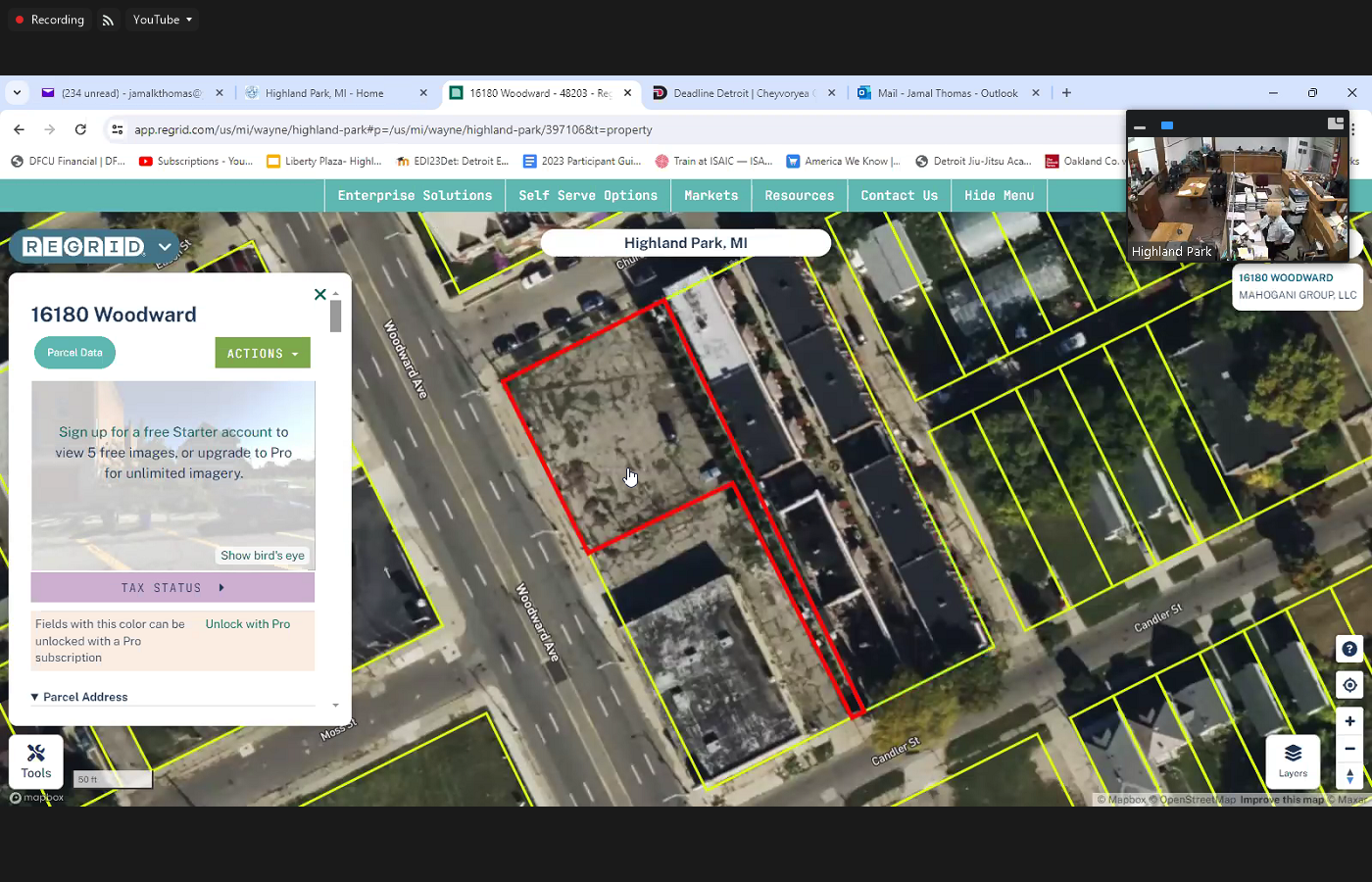
 a second. So so so if we want to do this let's do we have any additional citizens after this? We have Miss square. So let's okay. We have citizens that want to speak let me just let's just do this breeze. On the screen. On the screen, this is from land grid. Land grid has personal data for the entire United States of America that red box that you see there. This is the piece of property plus the alley that goes from one end to the other. This is this is the this is the parcel data that is submitted by Wayne County. Okay, this is not us. This is what submitted by Wayne County. So at some point, this is this is the voice property here. circled in red. This is the other property owner. That includes the alley that goes all the way from Chandler to church. A survey will probably be useful to find out who owns what again, remember the city is bordering 150 200 years old, there are a lot of parcels that are improperly labeled. And that's why I encourage citizens when you come to the meeting and I share these resources with you this is not special access anybody can get on regreat and look at the ownership of a parcel. And I would encourage you to do so because you might have some legitimate questions that can be answered by looking more closely at the parcel data, possibly having a conversation with Wayne County, but we're not in a position to speculate. And I hope that this tool will be helpful for you to dig a little deeper into this. And I certainly appreciate the chief trying to try to offer some sort of concessions.
+3
a second. So so so if we want to do this let's do we have any additional citizens after this? We have Miss square. So let's okay. We have citizens that want to speak let me just let's just do this breeze. On the screen. On the screen, this is from land grid. Land grid has personal data for the entire United States of America that red box that you see there. This is the piece of property plus the alley that goes from one end to the other. This is this is the this is the parcel data that is submitted by Wayne County. Okay, this is not us. This is what submitted by Wayne County. So at some point, this is this is the voice property here. circled in red. This is the other property owner. That includes the alley that goes all the way from Chandler to church. A survey will probably be useful to find out who owns what again, remember the city is bordering 150 200 years old, there are a lot of parcels that are improperly labeled. And that's why I encourage citizens when you come to the meeting and I share these resources with you this is not special access anybody can get on regreat and look at the ownership of a parcel. And I would encourage you to do so because you might have some legitimate questions that can be answered by looking more closely at the parcel data, possibly having a conversation with Wayne County, but we're not in a position to speculate. And I hope that this tool will be helpful for you to dig a little deeper into this. And I certainly appreciate the chief trying to try to offer some sort of concessions. 
Unknown Speaker
And I'll read that essay who owns it or
Speaker 1
so whenever you click on a parcel, it'll highlight red for that particular parcel. The map is all different colors, but when you select the parcel, it'll show you that parcel. The rough estimate for the last assessment that was done by the county regrade doesn't belong to any municipality or any county. This is a national GIS system where they store this data and anyone can have access to an argument. I remember
Speaker 3
this argument clearly when writing Patrick and it was setting up your own accountability to when they were trying to lean on them and force them out of their property in the first place. This has actually been said that it is bigger.
Speaker 1
That's not what the count is. Their outlets know what the county shows. Okay,
Speaker 3
I remember that argument. Okay. And we went through legals and everything over that argument and Ronnie Patrick and him conceded that that alley belongs to them. And now y'all want to go back once you start this process will begin when I started this process. Yes, they're freaking out. Yes, they're out. We
Speaker 4
can check the records to make sure in order to get an ally it has to be officially vaping you have to get a vacation of the easement. Look it up and help you just deal with it.
Speaker 1
That was my recommendation to get the data Mr. Hoyer. It's important that I'll help you to be solid in your position. I want to make sure that you have the data. So the data is whoever any additional citizens I wanted to come up for comment
Speaker 19
Good evening, honorable board. My name is Camille Edwards. I live on East Grand. I'm also a retired police officer that part time worker for choice towing. And a lot of the people that come in and complain about police, police complaints. They say they can't get in. They talked to him to a mic. They want to have a conversation with an individual they refused to open the door. We had an individual that came to the Troy's turn this morning. And he was so upset. Somebody told him to cut to make a complaint against the Troy's towing employees, which we weren't rude to him. He said it was Highland Park Police was rude to him. So I'm just I just want us to be mindful that we are public servants as police, police officers, please open the door and talk to the people they do not want to talk to a machine. They want to talk to an individual because sometimes
Unknown Speaker
a kind word
Speaker 19
will go a long way. Then I'm telling you go online and put your complaint in and that's and if I pay taxes,
Unknown Speaker
that's hurtful.
Speaker 19
Talk to me like I want to be talked to and I'm just complaining because I thought the man was gonna come and take you who was namias after the meeting is over. But I feel so bad for him because he said I know who you are. He said I know you're when you first came on as a police officer. I said I retired. And he said he's gonna come here tonight and I still don't see him. In the audience. So because he didn't show up. I'm gonna show up. Thank you
Speaker 1
sir, can you state your name for the record? Excuse me? Please state your name for the record. My
Speaker 20
name is Steve and now how can I put this? I've been in Highland Park for 11 years. I work with Leo Lee Steve Rubin on the Sanders bill and I'm quite sure pretty you've probably heard of me already because I came to approve the Commission's approval and I asked about Hamilton corridor. And the same as though the commission didn't know who Hampton corridor was not part of that, with the main group acquiring the land from the service drive all the way to Vale street. But they acquire that property and that land. I don't see Hamilton corridor in that sector but as to my property 59 doors and 14416 Lincoln. These two properties are on both ends and out. Now half the corridor has a contract to do anything over there for us and when I haven't heard anything as far as my property with regards to if you look in your database they had a PDF sheet when they acquired it 2021 saying all the car sales that they have purchased from service drive to the bill, but it might end up in a in a portfolio your platform what what kind of paperwork, our sector the area is not even in there. So our question, a question the commission I asked them who blah, who's Hamilton Cordova seemed as though they didn't know. And they said, well, sorry, you have to go to the council because they approve, aren't they? So I'm here at the council to ask you guys who was coming to corridor and they levy a lien against all the properties and defaulted everyone over there. Feel like as if I'm the only one to spin the fog because I don't know what's going on in information. I don't know if they purchasing this property. I don't know what the future is for this area. And I've been taking care of the area for 10 years. I have a beautiful home flowers all around it all the way from Oakland, to Lynwood. I've been just having that whole area for years. You said I'm saying as far as I'm concerned, a lot of things going on with regards to me as it posted an error.
Speaker 1
Let me get your address again sir, to you got 59 doors and what was the other 1111416
Speaker 20
set for Lincoln? Yes. What was it again? 14416. Lincoln 459. Doors one six now.
Speaker 1
Now just your two minutes is up and I wanted to make sure I get the information correct. This happened in the previous council. The thing that you're referring to is it didn't get didn't happen during this current council. So I'd like to again, I'm putting notes in administration might be able to answer your questions. I don't believe any of us have the purview because we were not city council people at that time. But I am writing it down. Can I have your name again? If you don't, my name
Speaker 20
is Steve but No, Steve. Yes. What does happen? One of the what happened? What did they tell you that you land? Well, this happened to 2021 just to see what they would do with regards to the case. I was said to lawyer by some community leaders of the community and with regard to these community leaders, I don't know what stakes they may have. But the Lord wasn't really competent to represent he didn't know anything about zoning.
Speaker 1
Well Mr. Bunnell, why don't we can't answer your questions. We gave you your two minutes I want to get if you don't mind. I get your phone number. I'd like to find out what your what your issue really is. It is kind of intriguing. So I would like to follow up with you is really more Yeah, I'm familiar with the project on both sides of city Detroit. So I'd like to know
Speaker 20
and I've heard you say you are LLC owner and sometimes it's best to put your property and how those suits are protected. And so my regards within a half a day to day we say there was an information say that my property was a drug house. See, let
Speaker 1
me stop you right there because I don't want to put your business in two minutes. You want to get two minutes and I would like to know, let's just proceed. Yeah, I want to I want to have to have a conversation with you appropriately. I say administrative like the squeaky wheel. I can get a chance. Okay. Okay.
Speaker 20
734-519-4406
Speaker 1
Thank you. So what follows you? Okay, that's great. 734519 Excuse me, sir. He says 734 or 51944064406. Okay. Also, you
Speaker 20
can also take down alternative number 810-525-6629.
Unknown Speaker
Thank you sir. Thank you. All right, Miss square.
Unknown Speaker
Large ski with her bike.
Unknown Speaker
I think she might be getting run around
Speaker 4
finding companies. You know, we're having our people insuring us. And I'm gonna help her so she can go ahead and be with her.
Unknown Speaker
Thank you, man. We have any additional citizens
Unknown Speaker
How you doing, sir?
Speaker 21
Fine, thank you. Hi, my name is Williams up please call me Billy. And I'm here to talk about recycling which Highland Park doesn't have but but first I want to mention our I just discovered the other day when I was looking at some things on solid waste online and discovered that that Highland Park is disposing of our yard waste illegally. You know that it's it's because I've seen the trash collection come and putting it right in the in the in the garbage Packer was the West rest of the garbage. And I learned the other day online. That that Michigan has had a lot since 919 92. That yard waste does not go in landfills. So that's happening here in Ohio.
Speaker 4
There's a season and it doesn't start probably until April 15. That's when the end it goes to December. First. So during the winter yard waste goes into regular trash. The season hasn't started yet,
Speaker 21
but that's when that's when yard. Monday was one that didn't have such a long
Unknown Speaker
35 week.
Speaker 21
I didn't I didn't say that and and the government website that I saw I didn't
Speaker 4
say that. The laws initiatives 35 week period, however
Speaker 21
what I was here to talk about is recycling, which Highland Park doesn't have. And back in 1971 I was working for city Highland Park and and I asked the city council to use a city truck to to use for recycling glass and and they directed me to the mayor's office and Mayor directed me to a Director of Public Works and and they lent me a truck on Saturdays to collect glass and several places in Highland Park I had barrel set up and and I would go to anyone's how to pick up their glass from them. If they would just let me know including the mayor Blackwell, who, instead of giving me his glass he just gave me his garbage is all of this garbage. You know is is gave us lip service to this like ecology program. But then Blackwell said that he had a deal with someone who was going to do recycling at Highland Park and he's going to make money on it. He put canisters up all over the city for collecting. Two minutes Billy my time was up, sir. We got to have time to talk about this sometime.
Unknown Speaker
Oh no. No, let me talk with you sometime about this or just let me know when we can do that. Okay,
Speaker 1
I have card all right thank you sir. Yes sir.
Speaker 1
Any additional citizens Okay, um, we're gonna move into Council affairs but let me just thank you for the citizens that come from citizens participation. Whenever I go to see council meeting in Detroit two minutes is not enough. But they have a structure that way. Maybe we need to make a change. I typically allow for three minutes. I know I say two minutes, but I have my stopwatch set at three minutes because two minutes is really not enough unless you rehearse this and many times, people come here to get things off their chest, and you cannot compress that into an elevator speech. Two minutes. I understand that but due to the constraints of time we have to have some sort of structure. So I know I say two minutes is typically three. Sometimes the stopwatch goes off and I don't even let you hear because I feel like people are in the middle of expressing themselves. This is an opportunity for citizens to participate. And we are bound by the rules but I don't enjoy. I don't enjoy being the keeper of the time. I just want to make sure that the meeting goes smoothly. So at this point, we're going to move on with the council affair starting with the councilman from the third district Mr. shopee The floor is yours
Unknown Speaker
even HP
Unknown Speaker
it's been a year
Speaker 3
and three months. pure hell have been threatened, harassed, intimidated, everything possible to break the problem is that you don't know me. You mess with me all he does is make me dig even further. All it does is pisses me off even more. That's what you now realize. Everything that you try against me, it just fuels the fire and the rage that exists within me in the first place. It doesn't douse the fire, doesn't put it out. makes it worse. You're actually aggravating and exacerbating the problem of who I actually show let me share some more of that which I don't appreciate how the treasurer has been treated. I don't appreciate how she was taught to don't appreciate the fact that it's clearly an act of discrimination. I don't like it one bit. You're doing to her exactly what Jim Crow did to us for 100 years and I find it unacceptable. And I think you're disgusting that it that all of a sudden when we ask questions about where this is a way that he is everybody's a flippin idiot all of a sudden. Nobody knows nothing. You extra? She don't know nothing. Yes to your ex the finance director. I have no idea. Everybody's retarded all of a sudden. And then we miss the bottom. How does the city move forward? How does it function when every time you turn around instead of you being square with me and walking with me and trying to get a good understanding? You got some game you want to play some childish to your last game that you want to play with you think they just go on to intimidate and break me No, no, that just makes it worse. So I have a few things. I want to put out a put out here today. First of all, I want to make a motion to approve whatever the cost for Ms.
Unknown Speaker
and I will appreciate a second from my councilmembers
Unknown Speaker
whatever the call
Speaker 1
so we have a motion on the floor. These specific in that motion would you
Speaker 3
I want whatever it calls for the bony pavement for Miss Lisa Laski to be paid for by the city as it has been paid for by for the previous treasurer.
Speaker 1
We know in fact what the previous trade doesn't matter. Whatever it is question I want to know. Do we know you made a reference to the previous
Speaker 3
topic and then we'll be taking care of it in whenever the cost for her time and
Speaker 1
don't Don't be paid. So there's a motion on the floor and it's been second made by Councilman Shafi and state the motion again for the record.
Speaker 3
Please call the roll. No sir. You say I've already stated I'm not calling the roll until you explain I've already explained this is clear as day whatever this host whatever the calls for her bond is she understands I make a motion that the city paid for that calls in order
Speaker 1
for the clerk to put it in the record Miss Madam Clerk Can you get it? Okay, would you please give it back
Speaker 9
whatever the cause he moves at the city paid for Mr. loskis Bang Okay, so
Speaker 1
we have a motion on the floor Bay my best job shopping. That whatever the cost the city pays Mr. Lara excuse bond, that bond that motion was seconded by council pro tem. Go ahead and call the roll on that which
Speaker 9
Councilman the Shafi Yes. Councilwoman Martin? No. Council Pro Tem Robinson. Yeah. Council President Thomas No.
Unknown Speaker
We want to councilman from District
Speaker 3
steel on the floor sir. I still have the floor. I still have the floor. I have not relinquished the floor. Um there's a lot of funny business going on with the city's finances. And you know, I've just I got it I have it in a pit of my stomach that is only about to get worse. So at this moment, I would like to make a motion for to request from the state. A third party entity to come in and do a full financial audit of the city's finances. financial audit of the city's finances.
Speaker 1
We have a motion on the floor from Councilman ash Shafi requesting a full audit or forensic What is it full?
Speaker 3
I say I am making a motion to request from the state to send a third party into Highland Park to do a full forensic financial audit of the city six spaces
Speaker 1
do we have a second? Okay. There's a motion on the floor from Councilman Shafi requesting that the state of Michigan come into Highland Park and do a full forensic audit. It was seconded by council woman Martin questions.
Speaker 9
Did you call the roll? Councilmember Shafie. Yes. Councilwoman Martin. Yes, council Pro Tem Robinson. Yes. Council President Thomas.
Unknown Speaker
No motion carries.
Speaker 3
Okay, now, last thing I would like to do. And I know I know I'm gonna catch some flack for this but I just I I just feel like if I don't do this, I'm gonna kick myself later. I've have to rescind my vote of Yes. For for the tentative agreement for the police department. I received it. I have to I'm sorry, because I'm worried about the budget. I'm worried about the finances. I received my vote. Okay. And I and I yield the floor to the next councilman.
Unknown Speaker
Thank you very much. Councilman Martin.
Speaker 22
Actually, you would have to be a motion for reconsideration.
Speaker 3
I'll make a motion to reconsider my vote for the tentative agreement for the police department.
Unknown Speaker
Support.
Speaker 1
We have a motion on the floor for the counselor meant to reconsider his vote. On a tentative agreement. It was supported by Pro Tem Would you please call the roll? Excuse me.
Speaker 7
If this has been called back up? I'd like to speak on this. Go ahead, sir. So what I want the citizens to understand is we crunched the numbers for our we went through everything we made sure and we're actually having a reduction of almost 200 and some $1,000 in salary for the city. We proposed right now, with our current state of numbers. We would we would be HPB spending towards more if we save sense. So we've crunched the numbers. We're able to provide you with what I believe is a more competitive police department with better staffing than what we have now. Let me be frank with you currently, we do not have remotely close to where we need to be in staffing levels for the police department to provide safety to the citizens. Okay. The reason for that is we are not competitive. We're not competitive with other agencies, Hazel Park, and train Detroit. They're paid about 15, almost $20,000 more than your current. So what I propose to you guys is if we're going to deny this to 14, you guys got to be prepared to pay a lot more to contract out to another agency. Because what I'm telling you well then you need to speak to a counselor because in a minute, we're going to lose our thesis. And people are gonna leave here and if RB got offers from other departments, members in our department right now have offers to leave this apartment and go elsewhere. So if you guys are prepared to have an unsafe city, I'd be fine. 42% reduction in violent crime in the last two years 42% In this state, transparency, we have all new technology by cameras. Our cameras can be monitored from anywhere, anytime. All we have GPS on every one of our officers we have GPS on every one of our carts, we made sure that we're providing a transparent department as to the city. So we want to talk about numbers. I get that I'm a budget guy. I understand. We are staying within the constraints of the budget that was allotted for us and we are beat and doing better than and in return you're going to provide better services. Now if you want things to go arrive and you want to work if you want to subcontract out I'll tell you right now, the only person who would even consider that possibly would be Wayne County and I just had a meeting with them and they are not interested. Okay. And when they were here before we paid almost two or $2 million for that, which is a significant portion of the budget were asking for and all they provided was main road service. So all the businesses were treated Great. However, the side streets, the residents, they were overwhelmed because they didn't a lot for that. That was staffing to the city because quite frankly, the city wasn't painful. It's better to own your police department. It's better to have policies we enacted 100 And something policies recently, thanks to council and thanks to the citizens for approving that. Our policies briefly.
Unknown Speaker
Every single thing is
Speaker 7
officers do it from it based on that we we can terminate an officer we can discipline officer. There's no traveling officers anymore. Their state laws. If we get a bad officer, they're gone. They're done their career. is over. We're monitoring them insisted and I say that we have a great Police Department. We had a good officers here that put their lives on the line. Every day they socialize with the with the residents say get out and help the residents. So everyone's waiting to hear a bad story that someone had a bad experience with a police. Let's be honest, every experience you have with the police if you don't get your way is not going to be perfect. Okay, you're gonna be upset when you get a ticket. Who's happy about that? know I'm not I've gotten tickets. In my life and then I go raise a man, the greatest officer I've ever dealt with. He wrote me a $300 ticket. No, I'm not gonna do that. Okay, but here's the reality. Their job is to enforce the law. Their job is to provide safety to the citizens and I think we're doing a very good job. They're
Speaker 1
so cheap to undo what just occurred you have a motion on the floor to reconsider to undo that you need a majority vote of city council members to undo voting for that tentative contract. That is what's on the floor. The motion was made by Councilman shopee supported by Councillor Pro Tem Robertson deputy deputy clerk would you please call it up the row on that reconsider?
Speaker 9
Councilman Shafi yes to reconsider. Councilwoman Martin. No. Councilwoman Robinson? Yes, Council President Thomas. No.
Unknown Speaker
Thank you very much. Miss Martin. The floor is yours.
Speaker 2
Okay. With that being said, welcome back. I wanted to address Miss Washington about what you said about what you said earlier about the bid. And you said it's about you know what it is they offer. You know, one price being you know, $90 and another price being 200. It's not even about what they offer. It's really about what we need. That's the part and can they cover that?
Speaker 4
But what they're gonna do, you are to read the bill and see if that is what you want. But what I'm saying is that that's what we need to do. Before we decide oh, we're gonna agree.
Speaker 2
there you are. Talking about the, you know, some people that, you know, we're you don't have the price of some of the bids that they apply or did they see it in the paper or how come they didn't apply? Okay,
Unknown Speaker
you wondering now when you say communication issue, what do you mean? I don't want to jump
Speaker 2
before Right, I've seen you before. Okay, so when we had the bids, how did you communicate to them that we had bid offers like how did you find out to tell them
Unknown Speaker
what you approved.
Speaker 2
Okay. And then from that point, they didn't come in. For more information Okay. And you know, those beats are closed. Okay. That's all I have to say about that. I definitely want to say thank you guys for being out here for so. So like, appreciate you for being here showing up. And I'm gonna go ahead and turn it over to pro Tim Robertson.
Unknown Speaker
Thank you, ma'am. Pro Tem.
Unknown Speaker
Good evening, everyone. Good evening. I have a couple of questions for you that you know how many people are
Speaker 22
on my staff? How many times are you Mr. Oh, 65, I believe. Okay. Yes.
Speaker 5
And you're also the labor attorney. Well, that's
Speaker 22
part of the function of a city attorney would be providing labor services.
Speaker 5
So just need to get clear, true. Essence arrived with someone in the labor exam,
Unknown Speaker
and no, I'm not representative the Union or the employees in regards to union issues. They have their own representations. Sure.
Speaker 1
Okay, Mr. Boyd, um, I pulled that information up about the alley behind your property because I want to give you a point to try to point you in the right direction to find out what's going on with the easement behind your property. If when you purchased the property, they didn't provide you with a survey of the land and might not be as cut and dry as it would appear. But if that parcel that I showed you shows that the owner of that lot in front of you do participate in the easement process or otherwise showing that long red stretch behind where your property is. It might be worthwhile to have a conversation with that gentleman as well. I would also recommend that you check with Wayne County specifically for property adjacent to yours to see if the easement on the other side where the alley is is also in question. It's really difficult to know where the property lines in many cases Wayne County tried. They said they do a good job they try to do a good job. But without a proper survey, which is exceptionally expensive. Without a proper survey. There's really no way to know. And so I wanted to at least try to point you in the right direction. It might be somebody at the window down over fish bones, it might be able to answer that question for you and you can use that information to maybe help you in your conversation with the cheat because it is I'm sure it has to be challenging for someone to receive a ticket outside their door. But I don't I don't want to make the assumption that there's malice behind it. I would like to see it come to a happy ending to places a place of peace every time I come there, I feel peaceful. So I will hope that this would at least point you in the right direction to get some answers to your questions. And I would recommend that you go home and look at regret WR e g ri d.com. And you can look at all the parcels around your property. They'll give you specific information and hopefully that'll be helpful to you to the brother that's on doors. I would like to give you my business card before you leave so that we can have a conversation. To see if I can offer some assistance. Mr. Fraser, who's been working on the other side of the Detroit side has some additional insight into some of the legal matters and I might be able to pair you with somebody who can answer your questions better than accurate. Yes, sir. Yes, sir. And possibly get to the bottom of that. Miss Monica is not with us today, but she did something for it as my mouth I'm gonna try and share my screen and see if we can offer this video from her. How not to play games with the sound here.
Unknown Speaker
Just give me a second see if I need to work
Speaker 1
first image mannequin Don't get mad at me. I tried to share it but because it's a live feed video all the microphones in the room are are backfiring into the zoom feature, so I'm gonna go ahead and stop sharing. April Fool's Day The joke's on us I guess. Say Gibson is the new Special Agent in Charge of the Detroit branch of the FBI and as members of city council wanted to call for a full audit of the city finances. I would like to ask Mr. Gibson to launch an investigation into members of the city council. Please. If you if you notice when you go online and you say I want to go to Disneyland or I want to get a blue toothbrush, the side of your screen will show trip to Disneyland and he'll show you a blue toothbrush and I know enough about the way that the internet works. And the way that the Federal Bureau of Investigation works is even saying his name is going to elicit some response, but I'm going to go one step farther. I'm going to reach out to him personally and ask him to really come and look at what's going on here in our city. I think it's important our job is to to look into the health, safety and welfare of the citizens of Highland Park and the phrase my grandmother used to say hit dog collar. It's just the City Council in general. As I said to you before in November, I believe the election was tampered with. I shouldn't be sitting here. I failed on my affidavit on the last day two hours before the window closed. It's like putting your hand in the jar with 1000 white marbles and pulling out three or four blue marbles. That was fraud. In the last election. There are people sitting in front of you who are in violation of federal law. We're guilty of federal crimes, falsifying affidavits. And I'd like to see if the section chief for the Detroit FBI can come in and look at that a little bit more closely. I'd like to see if that can happen because the city that we're talking about with the things that we do here, I saw some things today that I've never seen before. I've saw some things that I've never seen before and I'm not in a position to argue my job is to run the meeting. If you haven't noticed, I don't have any debate with other members. They can do whatever they want to do. You can run it to me you can drive into the school with your car if you want to. You can but you shouldn't you can stick up a bank but you shouldn't. So people can violate the law. It's not my job to stop them. But it is my job as city council president to make sure that I do what I'm supposed to do. And that's look upon the health, safety and welfare of this community. And if that means bringing the FBI into Highland Park, I think we should do so having concluded our business related to the city of Highland Park, the Chair will consider this meeting adjourned at 9:29pm